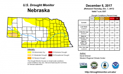
Dry November Conditions Lead to Major Shift in Drought Monitor
December 7, 2017
After a drier and warmer than normal November, the Drought Monitor showed a marked increase in how much of Nebraska was dry, increasing the "abnormally dry" area from 9% to 61% this week.

How windy was it? A look at Nebraska gusts Oct. 23-27
November 2, 2017
As evidenced by field after field of broken corn stalks and ears lying on the ground, the Nebraska plains were swept by winds of 30-50 mph, often over a sustained period, Oct. 23-27. Two tables show the peak gusts as well as how many hours in a given day two sites experienced high winds.

Growing Season Officially Over for Nebraska
October 31, 2017
On Oct. 28, the last of Nebraska's Mesonet weather stations recorded a hard freeze of 28°F, effectively bringing the state's growing season to an end. A table shows dates for 28°F and 32°F freezes as well as average dates for these thresholds for 63 sites.
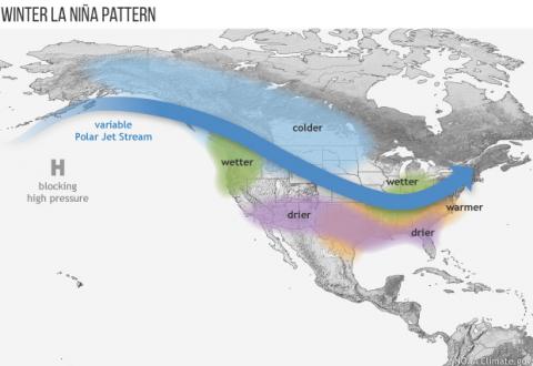
What Will a La Nina Winter Mean for the Midwest?
October 24, 2017
The Climate Prediction Center reissued its La Nina Watch on October 12, stating that the odds of a La Nina occurring during our North American winter have now increased to 55%-65%.
Scout Corn Fields for Kernel Set
August 4, 2017
Considering the day to day and week to week variability in weather we’ve experienced and the wide range of regional conditions across Nebraska this year, scouting fields for kernel set and overall condition may be more important than ever. Check out these corn reports from across the state.
Documenting Climate Data Relative to Pesticide Injury
July 27, 2017
With dicamba injury reports surging during the past few weeks, we want the public to be aware that historical data is available to research whether climatic conditions were a contributing factor.
Adjusting Forage Management for Summer Heat
July 18, 2017
The current heat wave is taking a toll on forage plants, particularly cool-season plants. Alfalfa and clovers, bromegrass, orchardgrass, fescues, needlegrasses, and wheatgrasses all struggle during hot weather, but adjusting your management can limit the stress from stressful weather.

Abnormally Dry Area Expands to 68% of Nebraska
June 30, 2017
Dry areas expanded in Nebraska for the second straight week with 68% of the state now labeled as "abnormally dry" by the US Drought Monitor.