
GDD/ET Tool
GDD/ET Tool
The GDD/ET Tool provides location-specific growing degree day and evapotranspiration data to help track crop development and guide irrigation decisions.
ET/GDD Tool
Additional ET Resources
- Publications on ETgage® and Watermark Sensors
- Using Modified Atmometers (ETgage) for Irrigation Management, NebGuide G1579. This NebGuide describes the atmometer (evapotranspiration gage) and explains how it can be used for irrigation scheduling. Examples are provided to show how information collected with an atmometer can be used to estimate crop water use for corn and soybean.
- Watermark Granular Matrix Sensor to Measure Soil Matric Potential for Irrigation Management — Defines soil matric potential and describes principles and operational characteristics of one of the electrical resistance type soil moisture sensors for irrigation management. Examples show how soil matric potential can be used for irrigation management.
- Extension Circular 765, Magnitude and Trends of Reference Evapotranspiration Rates in South Central Nebraska
- ETgage® and Watermark Sensor Instructions Checklist — Brief list of steps involved in using the ETgage atmometer.
- Predicting the Last Irrigation of the Season
- Irrigation Trigger Levels for Various Nebraska Soils (chart)
- CropWatch ET Resources: Maps of potential evapotranspiration rates for the High Plains Region
Crop Water Use by Plant Growth Stage
These charts can be used with readings from an ETgage® or other ET reference. To use the chart, first identify the change in the ET rate across the horizontal row and then identify the current growth stage in the left column. Follow the two columns to the point where they intersect to identify the ET rate to use in your irrigation scheduling. When planning irrigation, account for soil moisture, precipitation, weather conditions, and the ET rate for growth stage of your crop.
Estimating Growth Stage
Each of the Crop Growth Stage Charts listed above also includes illustrations of the growth stages. For more detailed information, see these resources:
- Corn Plant Development, a photo-illustrated identification guide for the reproductive and vegetative growth stages, developed by Iowa State University. The printed guide, Corn Growth and Development, is available from ISU.
- Soybean Growth and Management Quick Guide, a for-sale, photo-illustrated identification guide for the vegetative and reproductive stages of soybean; published by North Dakota State University. A printed guide, Soybean Growth and Development, is available from Iowa State University.


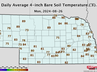
Check the High Plains Regional Climate Center's website for local, regional, and national climate data resources you can use when planning for your agricultural operation.
NERain Reports
The Nebraska Rainfall Assessment and Information Network (NeRAIN) is a citizen weather-monitoring program operated by the Nebraska Department of Natural Resources (NeDNR). The network consists of several hundred volunteers that record precipitation measurements and outstanding weather events for the NeRAIN website. NeRAIN information is updated daily, available to view on an interactive map as well as in several reports, or downloaded in table format.
Additional GDD Resources
Additional GDD Resources
- Nebraska GDD data is provided by the High Plains Regional Climate Center. It offers GDD for multiple crops and crop emergence dates for sites across Nebraska.