
Weather Monitoring and Planning Tools
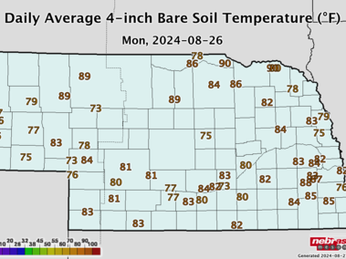
- Soil Temperature Summary for Nebraska (Source: Nebraska Mesonet)
(illustrated graphically and numerically by district) - Accumulated GDD and Crop Water Use (ET) Rates
- Nebraska Extension Crop Water Use Information
Rich resources of information on ET, soil moisture sensing and water management for crop production - Corn GDD, an online Useful to Usable Decision Support Tool for the Corn Belt
See current conditions and GDD in a 30-year perspective. - Evapotranspiration Resources and Crop Water Use Data by Growth Stage
(Corn, Soybean, Wheat, Alfalfa, Sorghum, Sugarbeet, Potato) - NeRAIN Reports and Maps (Nebraska Rainfall Assessment and Information Network)
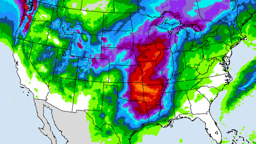
Daily precipitation reports from hundreds of Nebraska sites - Precipitation Summary (Source: High Plains Regional Climate Center)
- Ag Climate View Tool, a Useful to Usable U2U decision support tool
Access customized historical climate and crop yield data - Ag Climate Connection, a blog with news and views on climate change in the Corn Belt
Weather Outlooks
First Friday
First Friday is a monthly Nebraska Extension weather webinar featuring insights on current conditions and the long-range outlook for the Midwest.


Drought

Drought Resources
- U.S. Drought Monitor
- Drought Outlooks and News
- Crop Production and Drought
- Drought-Related Maps
- National Drought Mitigation Center
- Drought Planning Tools
- Drought Monitoring Tools
- Drought Monitor News
- QuickDRI Map - Areas drier or wetter than four-week historical normals

FSA Financial Assistance for Drought-Impacted Producers
If your county has been declared a natural disaster area, you may be eligible to apply for financial and direct services. View the current counties declared as natural disaster areas at USDA FSA.
On farmers.gov, the Disaster Assistance Discovery Tool, Disaster Assistance-at-a-Glance fact sheet, and Loan Assistance Tool can help you determine program or loan options. To file a Notice of Loss or to ask questions about available programs, contact your local USDA Service Center.
Recent Articles


Additional Weather and Climate Resources
- Nebraska State Climate Office
- Nebraska Mesonet, data from weather reporting stations across the state
- High Plains Regional Climate Center (HPRCC) provides weather data for a number of Nebraska sites and links to local, regional, and national climate resources.
- National Drought Monitor. Drill down to state drought information by clicking on the desired state once, which takes you to regional information, and then a second time to access state information.
- National Weather Service
- National Weather Service Central Region Field Office
- Climate Prediction Center (National Weather Service) with short- and long-term temperature and precipitation outlooks