Research Shows Large-Scale Irrigation Reduces Local Precipitation
February 28, 2018
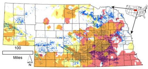
A University of Nebraska-Lincoln researcher has shown that widespread irrigation has resulted in a net moisture loss in Nebraska, a finding that could have worldwide water conservation implications if substantiated by further research.
")
North Platte River Basin Water Update
June 1, 2017
After good precipitation over the winter and spring, most of the reservoirs in the North Platte River basin in Wyoming are at or near capacity with more snowmelt/runoff still expected.
Nebraska Researchers on Multi-State Team to Study Psychology of Water Use
May 17, 2017
Six University of Nebraska researchers will join colleagues at Penn State University, Arizona State University and the U.S. Department of Agriculture’s Agricultural Research Service (USDA/ARS) to develop a model for engaging communities and stakeholders around issues of sustainable water use. The project will help us better understand how farmers and other water users get information and make decisions about water usage in agriculture.

North Platte River Water Update — US Bureau of Reclamation
April 21, 2017
North Platte River water operations and deliveries are expected to be normal for the 2017 growing season with an expected demand of 1.1 million acre-feet, according to a US Bureau of Reclamation forecast presented at the University of Nebraska Panhandle Research and Extension Center in Scottsbluff April 19.
Kansas University Research: ‘Weather Whiplash’ Triggered by Changing Climate will Degrade Midwest’s Drinking Water
April 3, 2017
One consequence of global climate change is the likelihood of more extreme seesawing between drought and flood, a phenomenon dubbed “weather whiplash.” In a peer-reviewed study researchers at the University of Kansas discuss how weather whiplash in the American Midwest's agricultural regions may after water quality, forcing municipalities to seek costly remedies to provide safe drinking water to residents.
")
Status of North Platte River Water Reservoirs
February 14, 2017
I usually start reporting on river flows and water reservoirs affecting western Nebraska in early May, but with recent national news about the spillway at the Oroville Dam in California, you may be wondering about the status of snowpack water content and the reservoir levels along the North Platte River in Wyoming.

North Platte River Basin Water Update
May 31, 2016
Minor to moderate lowland flooding is still occurring along the North Platte River from Lewellen west into southeastern Wyoming and will continue for several weeks or months. The areas affected are primarily the river bottom, pasture, and low-lying agricultural production fields. Some areas are near flood stage and others have exceeded flood stage.

North Platte River Basin Water Update
May 4, 2016
Recent storms rolling through southeast Wyoming and the Nebraska Panhandle have brought considerable moisture to the North Platte River Basin. The typical time for runoff/snowmelt in the Snowy Range and Sierra Madre mountains in southeastern Wyoming is mid-April; however, this year it was delayed several weeks and is just starting.