This is the last article in a series that summarizes the simulated crop stages and yield forecasts across the Corn Belt. To evaluate, in "real-time," the impact of this season’s weather on corn yield and its spatial variability across the Corn Belt, simulations of 2016 end-of-season corn yield and real-time crop stage were performed for 41 locations. The simulations were developed using the UNL Hybrid-Maize model in collaboration with faculty and extension educators from 10 universities.
Data for the Sept. 21 forecasts for actual and potential yields, as well as predicted dates for physiological maturity (“black layer”) are available. Previous corn yield forecasts for this year can be found here. Details on Hybrid-Maize and underpinning methodology to forecast end-of-season yields, as well as information on interpretation and uses of yield forecasts, are described in a previous article.


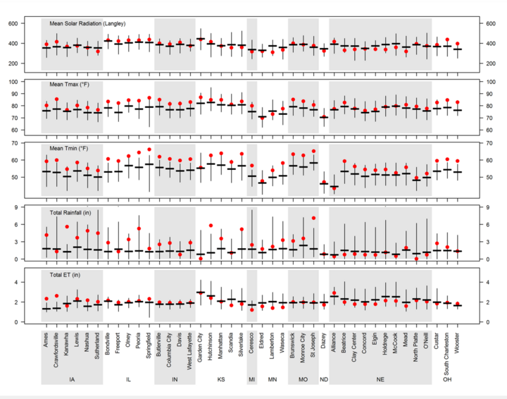
Figure 3. Daily solar radiation, maximum and minimum air temperature (Tmax and Tmin), total rainfall, and total reference grass-based evapotranspiration (ET) from September 7 to September 21, 2016. Vertical bars indicate the range for these variables based on 20+ years of weather records. The horizontal thick line indicates the long-term average and the red dots indicate the 2016 values.
Physiological maturity (black layer) has been reached at all sites, except for western Nebraska (Alliance and North Platte), North Dakota, and Michigan. The crop season ended with above-average temperature across the entire region and above-average rainfall in the central and eastern regions of the Corn Belt. In general, crops did not experience a water deficit during the last phase of the grain-filling period. Weather conditions during the last two weeks are shown in Figure 3.
Irrigated Corn: Slightly Above-Average Yields
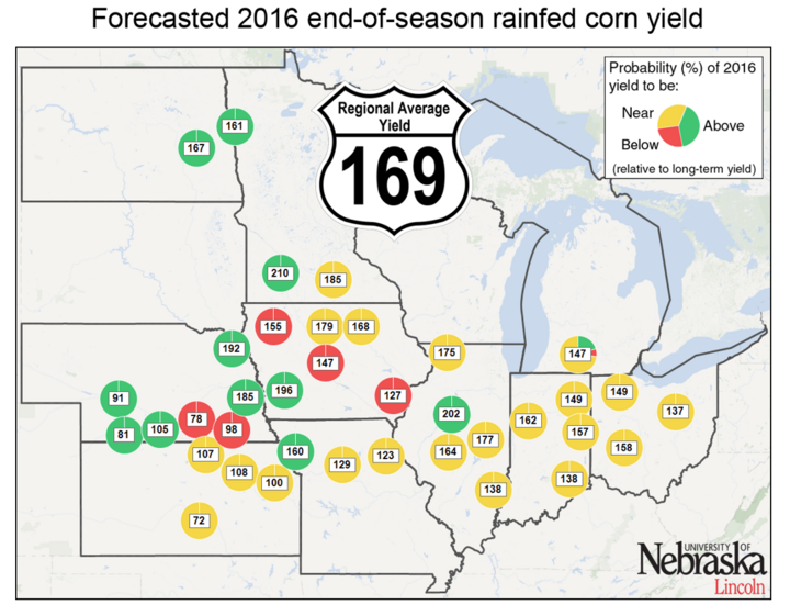
End-of-season forecasted irrigated yields are shown in Figure 4. Most sites exhibit yields near or slightly above average (from -2% to +9%), except for O’Neill (above average by 14%) and Beatrice (below average by 11%). Overall, regional irrigated yield is forecasted to be slightly above average (+5%). The two sites in western Nebraska where corn has not already matured (Alliance and North Platte) will exhibit yields above or near average depending upon temperature during next week.

Figure 4. Forecasted end-of-season average rainfed and irrigated yield at each location (bushels per acre). Colors indicate that 2016 yield was below (≤10%, red), near (±10%, yellow), or above (>10%, green color) the long-term (2005-2014) average at each location. Corn has not reached maturity in western Nebraska (North Platte and Alliance), North Dakota (Dazey), and Michigan (Ceresco).

Rainfed Corn: High Yield Variation Across Sites
Forecasted end-of-season yields for rainfed corn indicate near-average yield at 21 of 37 rainfed sites (Figure 4). These sites are located mainly in the southern and eastern regions of the Corn Belt and also in northwestern Iowa (Kanawha and Nashua), southeastern Minnesota (Waseca), and northern Illinois (Freeport). Above-average yields are expected for 11 of the rainfed locations: western and central Nebraska (North Platte, Holdrege, and McCook), central-east and northeastern Nebraska (Mead and Concord), southwestern Iowa, and northwestern Missouri (Lewis and St. Joseph), eastern North Dakota, western Minnesota (Dazey, Eldred, and Lamberton), and central Illinois (Peoria). In contrast, the forecasts indicate below-average yield at five sites: southeastern Nebraska (Clay Center and Beatrice), and across a southeast-northwest transect in Iowa (Crawfordsville, Ames, and Sutherland).
State-Level and Regional Forecasted Corn Yields
Our yield forecasts were upscaled to state level using the spatial framework of the Global Yield Gap Atlas, which is based on agro-climatic zones and distribution of corn harvested area. Forecasted yields for 2016, for each state and water regime, as well as for the entire region, are shown below. For comparison, we also show the average and highest corn yield reported by USDA-NASS for the last 10 years. Forecasted 2016 yields fall:
- well above-average (10% or more) for rainfed corn in Nebraska and Minnesota;
- above-average (from 3% to 9%) for rainfed corn in Illinois and Kansas, and irrigated corn in Nebraska and Kansas;
- near-average for rainfed corn in Indiana and Missouri; and
- below-average (from -3 to -4%) for rainfed corn in Iowa and Ohio.
| State* | Water regime |
Forecasted 2016 yield |
Average (2006-2015) yield | % deviation‡ | Previous record yield (bu/ac)¶ |
|---|---|---|---|---|---|
| Nebraska | Irrigated | 200 | 191 | +5 | 207 |
| Rainfed | 151 | 126 | +20 | 154 | |
| Kansas | Irrigated | 200 | 186 | +8 | 206 |
| Rainfed | 99 | 93 | +6 | 123 | |
| Iowa | Rainfed | 163 | 170 | -4 | 192 |
| Minnesota | Rainfed | 198 | 164 | +21 | 188 |
| Missouri | Rainfed | 137 | 135 | +1 | 186 |
| Illionois | Rainfed | 175 | 166 | +5 | 200 |
| Indiana | Rainfed | 154 | 156 | -1 | 188 |
| Ohio | Rainfed | 151 | 155 | -3 | 176 |
| Regional Average § | Rainfed | 169 | 161 | +5 | 180 |
|
* North Dakota and Michigan were not included because we only forecasted yield for one site at each of these states. Note that uncertainty in Minnesota statewide yield is also higher due to the small number of sites for which corn yields were forecasted. |
|||||
Conclusions
We'd Like Your Feedback
Please take a moment to answer two short survey questions about the 2016 Corn Yield Forecasts in CropWatch. Take survey.In September USDA-NASS forecasted a record national corn yield of 174.4 bushels/acre for 2016. Our end-of season forecasts made on September 21 also suggest that average yield will be above average but, in contrast, our forecasts do not point to a record yield. Regional average yield, based on the eight states listed in Table 1, and including rainfed and irrigated corn, is forecasted to be 169 bushels/acre. This forecast is 5% above the historical (2006-2015) regional average yield but well below the historical yield record. Hence, our corn yield estimate is lower that the USDA-NASS forecasted yield. This may be explained by the approach followed in the Yield Forecast Center, based on robust simulation models that account for temperature effects, especially high night minimum temperature.
Note that these forecasts do not take into consideration problems with stand emergence, hail/flooding damage, replanting situations, disease, or nitrate leaching. Therefore, in fields negatively affected by these constraints, actual yields will be lower than estimates provided here. It is important to keep in mind that yield forecasts are not field specific and, instead, represent an estimate of average on-farm yield for a given location and surrounding area in absence of the yield-reducing factors mentioned here.
For more information contact Patricio Grassini at pgrassini2@unl.edu or 402-472-5554.

