Patricio Grassini, Associate Professor of Agronomy and Horticulture, Extension Cropping System Specialist and Water for Food Institute Fellow; Jose Andrade, UNL Research Assistant Professor of Agronomy and Horticulture; Juan Ignacio Rattalino Edreira, Research Assistant Professor; Gonzalo Rizzo, UNL Ph.D. Student; Haishun Yang, Associate Professor of Agronomy and Horticulture and Water for Food Institute Fellow; Keith Glewen, Extension Educator, and Jennifer Rees, Extension Educator; Jeff Coulter, Professor and Extension Specialist, University of Minnesota; Mark Licht, Extension Cropping System Agronomist, and Sotirios Archontoulis, Assistant Professor, both at Iowa State University; Ignacio Ciampitti, Crop Production and Cropping System Specialist and Assistant Professor of Agronomy, Kansas State University; Ray Massey, Extension Professor, University of Missouri; Peter Thomison, Extension Specialist and Professor, Ohio State University
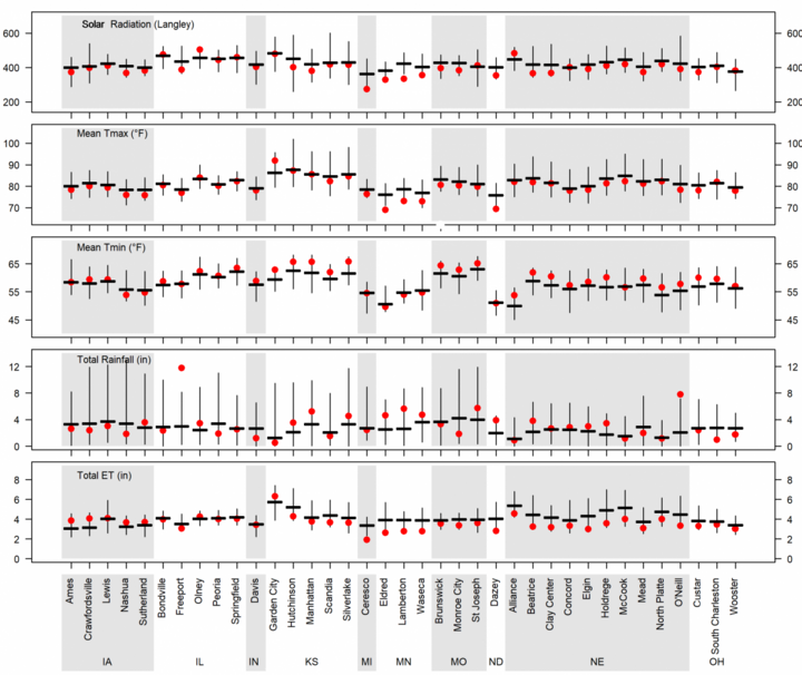
This is the last article in a series that summarizes the simulated crop stages and yield forecasts across the Corn Belt. To evaluate the impact of this season’s weather on corn yield and its spatial variability across the Corn Belt, simulations of 2019 real-time crop stage were performed for 37 locations across the Corn Belt using the UNL Hybrid-Maize crop model; the data can be viewed here. Details on the UNL Hybrid-Maize crop model and the underpinning methodology to simulate phenology and forecast end-of-season yields is described in a previous article.
Crop Stages and Weather Conditions during The Past Month
Corn has reached black layer at most locations, except for the northern (northern Iowa and Nebraska, Minnesota, and North Dakota) and eastern (Ohio, Indiana, Michigan, and eastern Illinois) regions of the Corn Belt (Figure 2). During the last month, most locations exhibited near-normal rainfall except in North Dakota, Minnesota, and a few sites in Nebraska that showed above-normal rainfall.
Night temperature tended to be above normal in all states except for those in the northern fringe of the Corn Belt (North Dakota, Minnesota, and Michigan), where night temperature has remained near normal. A summary of weather conditions during the past four weeks is shown in Figure 1.
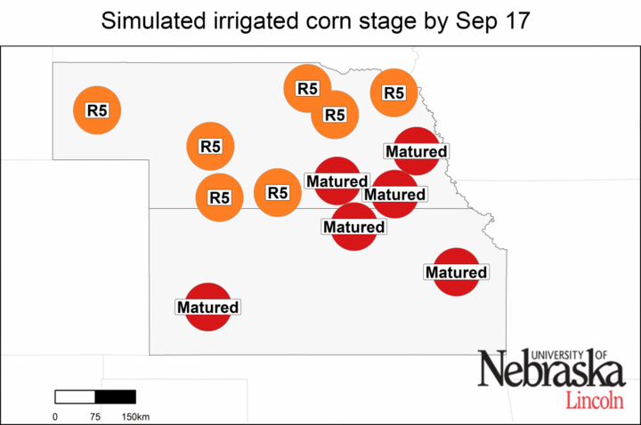
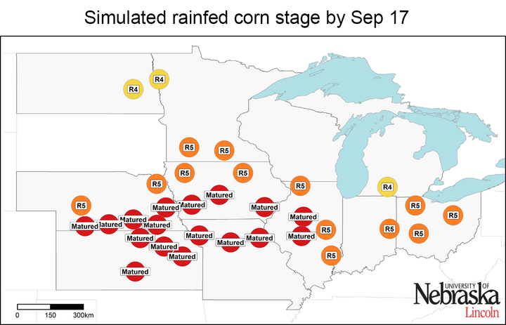
Figure 2. Simulated developmental stage for irrigated and rainfed corn at each location. R4: dough; R5: dent; matured: physiological maturity.
Near Or Above-Average Yields In Irrigated Corn
Forecasted end-of-season irrigated yields are shown in Figures 3 and 4. About 40% of the irrigated sites exhibited near-average yields in southeast Nebraska and Garden City, Kansas, and most likely will in northeast Nebraska. Three sites presented above-average yields (Silverlake, Scandia, and McCook), which is also the most likely scenario in western Nebraska. Northern sites in Nebraska, where corn has not already matured, still have a small chance of below-average yield associated with frost-damage risk as shown in Table 1, but, overall, they also look like they will reach near-average yields.
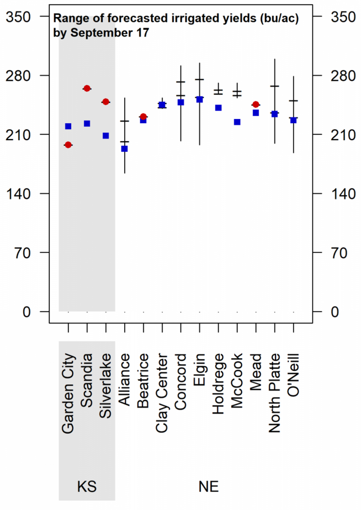
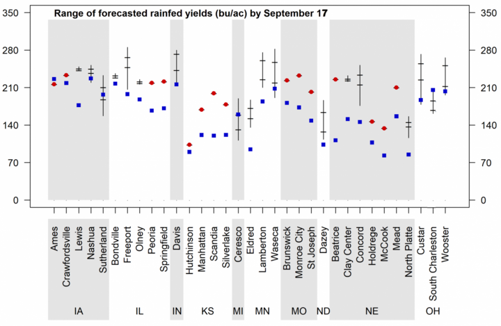
Figure 3. Vertical lines indicate the range of forecasted 2019 corn yield potential by September 17 based on average 2019 planting date at each location. Horizontal lines indicate the 25th and 75th percentiles of the yield distribution (associated with respective adverse and favorable weather scenarios during the rest of the season). The blue squares indicate the long-term (2005-2018) average yield potential at each location and the red dots represent the forecasted 2019 corn yield potential at sites that have already reached maturity. Separate charts are shown for irrigated corn and rainfed corn.
Above-Average Yields Prevail For Rainfed Corn
Forecasted end-of-season yields for rainfed corn indicate above-average yield at two-thirds of the sites (Figures 3 and 4), with yields well above historical averages in Nebraska, Kansas, and Missouri. In contrast, most sites in Iowa and Bondville, Illinois are forecasted to be near average. Only one site (South Charleston, Ohio) is expected to be below average. In the case of Michigan, there is a high probability for yield to be below or near average.
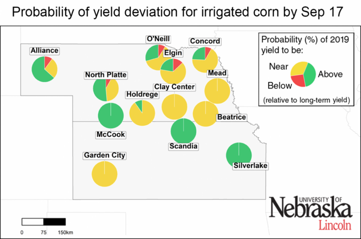
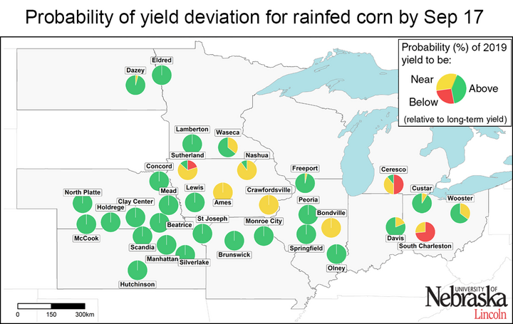
Figure 4. Probability of the 2019 yield potential to be below (10%, green color) the long-term (2005-2018) average yield potential at each location. Separate maps are shown for irrigated corn and rainfed corn. The larger a color section is within the pie chart, the higher the probability that end-of-season corn yield will be in that category.
Conclusions
Overall, it looks like a good year for corn at most sites for which we performed the yield forecasts, except for one site in the eastern fringe of the Corn Belt. Still, note that these forecasts do not take into consideration problems with stand emergence, hail/flooding damage, replanting situations, disease, or nitrate leaching. In fields negatively affected by these constraints, actual yields will be lower than estimates provided here. It is important to keep in mind that yield forecasts are not field-specific and, instead, represent an estimate of average on-farm yield for a given location and surrounding area in absence of the yield-reducing factors mentioned here. Likewise, crop stages and forecasted yields will deviate from the ones reported here in fields with planting dates or hybrid maturities that differ markedly from the ones used as the basis for the forecasts.
