Al Dutcher - Associate Nebraska State Climatologist

Comparing 2016 Summer Temperatures with 2015

August 9, 2016
A comparison of high and low temperatures across Nebraska in June and July shows a stark difference from 2015 to 2016, particularly in June. Some sites had as many as 14 more days with maximum temps over 90°F or 13 days with minimum temperatures over 70°F in June 2016.

Read more

30-day precipitation forecast

Undulating Heat, Cooler Temperatures to Continue

August 4, 2016
As we enter the final stretch of the growing season, weather models are indicating that the pattern of heating up during the work week and cooling down on the weekends will continue at least through mid-August. There even appears to be a good chance that above normal moisture may be realized across the southern half of the state as monsoon moisture works around the periphery of the upper air ridge projected to be positioned across the south central High Plains the next two weekends.

Read more

Seven-day US precipitation map

Forecast: Hot, Dry Conditions to Break Next Week

June 16, 2016
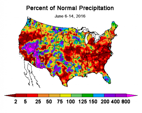
After a cool start to the growing season coupled with copious rainfall, temperatures the past 10 days have felt more like July, leading to leaf rolling in corn in eastern Nebraska. Earlier cool temperatures may have partially masked accumulating soil moisture deficits. Expect continued hot, dry conditions through June 20 and then a drop to the 80s through June 24.

Read more

June to August CPC precipitation forecast

Expect More Moisture, Then a Drier La Nina by Late Summer

May 25, 2016
As El Nino winds down, expect above-normal precipitation during the early summer and drier conditions as La Nina moves in in late summer. With the levels of snowpack feeding the North Platte River, flooding along the river is expected to continue.

Read more

Managing N in a Wet Spring

May 5, 2016

USDA NASS estimated 26% of Nebraska’s corn acres had been planted as of May 2, well behind last year’s pace of 45% and slightly behind the five-year average of 31%. The pace is undoubtedly being affected by the amount of precipitation across the state and the wet field conditions (Figures 1 and 2).

Read more

Shift to La Nina Likely in Late Summer or Earlier

May 2, 2016

It has been exceptionally wet since mid April with south central and southwest Nebraska receiving enough moisture to eliminate short-term dryness concerns that dominated the early February through mid-April period. Moisture data from NERain stations show that at least 253 stations recorded over 5 inches of moisture April 15-30.

Read more

Q&A: How are Soil Temperatures Recorded?

April 29, 2016

Q: When and how are CropWatch soil temperatures recorded?

Read more

US map showing precipitation distribution for the 7 days previous to 7 a.m. April 21
Figure 1. NOAA Next Generation Radar (NEXRAD) one-week precipitation estimates ending at 7 a.m. ET April 21.

April Showers Expected to Continue in Spurts

April 21, 2016

A well forecasted spring storm system brought significant moisture to a substantial area of the southern and central High Plains this past week.

Read more