After a cool start to the growing season coupled with copious rainfall, temperatures the past 10 days have felt more like July and precipitation events have become significantly sparser. A close examination of precipitation tendencies during the past two months portrays a disturbingly dry trend across a significant portion of the central and eastern Corn Belt. Unfortunately, this dry trend has intensified westward into the western Corn Belt during the past three weeks.
As temperatures have soared into the 90s and beyond, there have been widespread reports of corn exhibiting leaf rolling from eastern Nebraska through eastern Ohio. As much of this area experienced cool temperatures during early vegetative growth, some leaf rolling could be due to the crop not being acclimated to the sudden onset of heat. It also could be that the lack of precipitation is influencing corn physiology.
I warned during my fall and spring talks that if the upper air trough persisted over the Great Lakes region through the spring and into the growing season, the eastern Corn Belt could be susceptible to flash drought conditions. Areas to the north of the mean trough would experience cooler than normal temperatures and below normal precipitation. The longer it persisted, the more likely it would be that a short intense heat wave would expose the crop to moisture stress that had been building, but not readily visual, because cool temperature were masking accumulating moisture deficits.
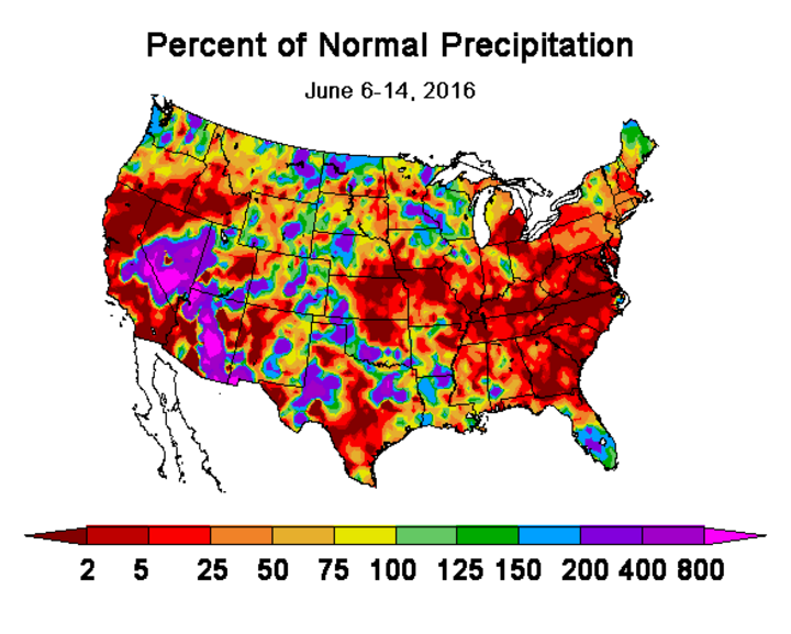
According to Figure 1, precipitation during the past week was concentrated across the northern Plains, with some southward extension into portions of eastern Iowa, northern Illinois, and portions of western Indiana. Precipitation was more scattered or nonexistent south of this region, adding to precipitation deficits that have intensified during the past 30 days.
Although excessive moisture continues to plague portions of the eastern Dakotas and southern Minnesota, much of the remainder of the Corn Belt welcomed the event as a break from a dismal precipitation trend that has persisted across the eastern Corn Belt for the last two months. The saving grace has been that the corn crop was planted later than normal and a lack of substantial heat has helped curb excessive crop moisture demands.
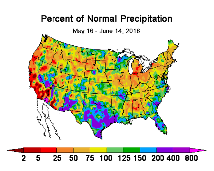
Figure 2 depicts the past 30-day precipitation trend across the Corn Belt. Even with the most recent moisture, the Corn Belt from western Nebraska through Ohio has experienced below normal moisture. The most intense dryness as measured in percent-of-normal would be northern Indiana and southwest Michigan. Well over 50% of Illinois, Indiana, and Ohio have received less than 75% of normal moisture.
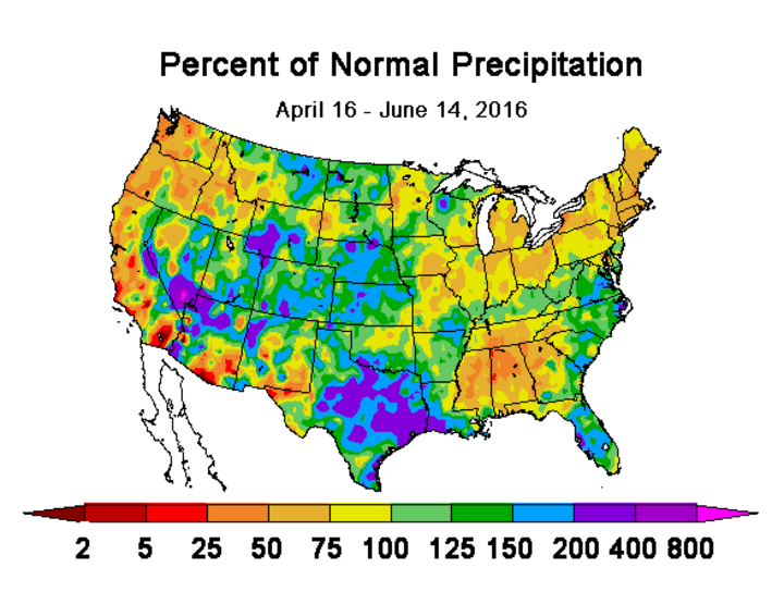
Looking back further, this same region had approximately 95% of its surface area receiving less than 75% of normal moisture; 50% of the area received less than half of its normal moisture (Figure 3). In fact, most of southern Iowa and northern Missouri have also experienced widespread dryness in the past 30- and 60-day periods, as well as, Alabama, Georgia, Mississippi, and Tennessee.
If the Gulf coast states continue the 60-day trend of drier than normal conditions, it is likely that a greater portion of the moisture normally transported northward to generate precipitation in the eastern Corn Belt will go to wetting the lower atmosphere instead. When this happens, precipitation output may look impressive on radar, but actually results in light events at the surface.
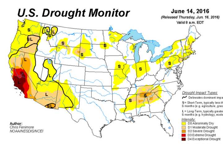
The U.S. Drought Monitor is starting to reflect concerns about the dryness impacts on agricultural crops. The June 14 Drought Monitor (Figure 4) indicates several areas where “abnormally dry” conditions have been introduced across the Corn Belt. There is a high probability that these areas will rapidly expand next week if the current forecast of 90s to low 100s coupled with little moisture verifies. In fact, some areas depicted as abnormally dry this week will likely upgrade to moderate drought conditions next week.
The most recent weather models point to hot conditions through the June 20, before another trough moves across the northern Plains and pushes far enough south to drop high temperatures into the 80s through June 24. Precipitation chances have also begun to increase with each successive model run and give Nebraska several opportunities for moisture as the ridge responsible for our recent heat begins to push back into the central U.S.
Energy moving around this ridge is forecasted to place much of Nebraska on the northeastern periphery, which would increase our chances of waves moving from the northwest to the southeast during the period. If these precipitation chances fail to materialize, the next decent shot of moisture won’t be until June 27. Unfortunately, if the moisture misses us, the ridge builds back into the region pushing highs back into the middle to upper 90s from June 24 through at least the June 27.
