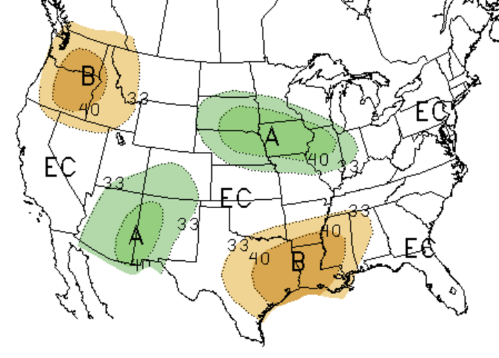
As we enter the final stretch of the growing season, weather models are indicating that the pattern of heating up during the work week and cooling down on the weekends will continue at least through mid-August. There even appears to be a good chance that above normal moisture may be realized across the southern half of the state as monsoon moisture works around the periphery of the upper air ridge projected to be positioned across the south central High Plains the next two weekends like the moisture output indicated in the 30-day forecast (Figure 1).
The flip side is that heat and humidity are predicted to return rapidly into to our region when the ridge builds northward and eastward in response to upper air troughs moving across the northern High Plains and deepening over the Great Lakes region. This pattern has now been consistent since late June and shows no sign of letting up in the immediate future.
Thus, dryness issues intensify each time precipitation fails to materialize when the trough passes through the region and is replaced by the upper air ridge. What has gone relatively unnoticed is that the peak maximum temperatures associated with the last two weekly episodes have actually decreased an average of 2 degrees per weekly event. Peak maximum high temperatures were in the upper 90s to lower 100s, but have cooled to the mid to upper 90s.
It is the low temperatures during these hot spells that have not shown signs of abating. They have remained consistently in the low to mid 70s across most of the eastern three-fourths of the state whenever the upper air ridge is the dominant feature in our weather. The result has been sultry days with heat index values commonly in the 100-115°F range and nighttime temperatures that don’t drop into the upper 80s until after sunset.
Developing Drought Conditions
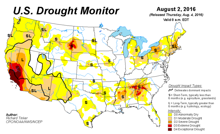
Heat and the lack of significant moisture has led to a gradual increase in drought conditions across southern and western Nebraska (Figure 3). Moderate drought conditions now cover a sizeable area of south central Nebraska including the Hastings and Grand Island area. Abnormally dry conditions have expanded west into southwestern Nebraska, but have shrunk slightly across the extreme southeastern areas along the Missouri River.
Short-term model projections during the next week indicate that areas south of I-80 could see 2-3 inches of moisture, with most of it coming this weekend. This moisture is the result of the northern fringe of the upper air ridge laying across northern Nebraska. An intense monsoon flow from the southwestern U.S. will funnel atmospheric moisture northeast into central Colorado, then eastward along the ridge periphery. If the models verify, drought reductions are likely next week; if they fail, further drought intensification is likely.
Additionally, a second moderate drought area covers the western half of the Panhandle north of Scottsbluff due to below normal moisture and high temperatures consistently breaching the 100°F mark. This region is on the southern extent of the severe drought region centered over the South Dakota Black Hills.
Although there has been an increase in thunderstorm activity during the past two weeks across the northern Panhandle, the repetitive nature of highs broaching the 100°F mark has increased evapotranspiration rates sufficiently to offset the benefits of recent rainfall. If cooler temperatures begin to become more dominant and recent precipitation trends continue, the current drought depiction should improve.
Potential for Late August Precipitation
There is tremendous uncertainty in regards to what type of pattern will develop during the second half of August, but I believe persistence is the best forecast for the time being. The persistent forecast would be for a cool down for two to four days followed by above normal temperatures for three to five days. The only significant change is that as the northern jet begins its southward drift to its winter minimum position across the southern U.S., Nebraska currently lies is a position to take advantage of a robust monsoon moisture flow.
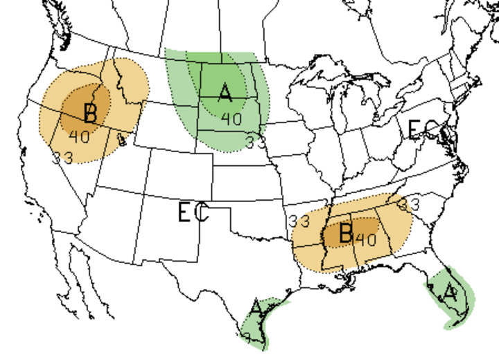
Even the current 30- and 90-day forecasts (Figures 1-2) point toward wetter than normal conditions across Nebraska. These are only projections and until we see consistent rainfall across our dry areas, we need to be alert to the possibility that further crop deterioration is likely.
