Part 2 of a six-part series on the dams, reservoirs, power generation and some diversion dams located on the North Platte River. The series will follow a chronological order of the history and construction of these projects.
Related Articles:
- Part 1: The North Platte River Basin Projects — Background
- Part 2: The North Platte Project – Pathfinder, Guernsey and Whalen
- Part 3: The Kendrick Project — Seminoe and Alcova
- Part 4: The Pick-Sloan Missouri River Basin Project — Kortes
- Part 5: The Pick-Sloan Missouri River Basin Project — Glendo
- Part 6: Other Dams, Reservoirs and Powerplants – Nebraska and Wyoming
The North Platte Project – Pathfinder, Guernsey and Whalen
The “TEACUP” model graphic from the Bureau of Reclamation in Figure 2 shows the dams and reservoirs on the North Platte River in Wyoming, their total capacities, current capacities, the inflows and outflows.
When the Reclamation Act passed by Congress in 1902 and the United States Reclamation Service was created, studies were conducted to determine where water projects could be constructed. Initially, the Sweetwater River (Sweetwater Project) was considered to construct a dam at “Devils Gate” to provide irrigation water. However, insufficient flows in the river did not justify the construction of a dam. The Reclamation Service then determined that a dam would be constructed on the North Platte River in the Fremont Canyon approximately 47 miles southwest of Casper, Wyoming.
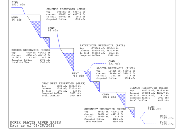
Figure 2
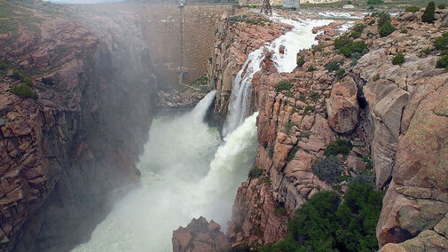
The Sweetwater Project was renamed the North Platte Project, consisting of Pathfinder Dam, reservoir and dike. The Pathfinder Dam was one of the first constructed by the U.S. Reclamation Service using granite blocks quarried near the dam construction site. Each block weighed eight to 10 tons and moved into place using a series of cable ways and derricks. Construction took place from late fall throughout the winter into early spring before the spring snowmelt runoff occurred. Wagon teams delivered construction material for the dam from Casper. Construction started in 1905 and was competed in 1909. The final dam construction method was an “Arch-and-Crown Cantilever Method”, which serves to function as an arch and gravity dam. This method distributes the load between the vertical cantilevers and horizontal arches. The dam is 214 feet high and 432 feet from canyon wall to canyon wall.
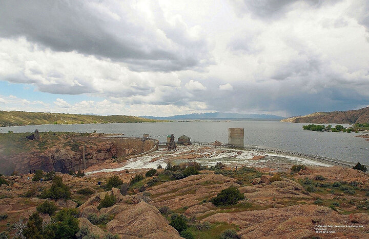
Figure 3. Pathfinder dam, reservoir, and new spillway ogee weir.
Current capacity of the Pathfinder Reservoir is approximately 1,070,000 acre-feet water. In 2012, a new ogee weir was constructed for the natural spillway overflow, replacing the old weir. This raised the level of the reservoir by approximately 2.4 feet to offset any sediment in the reservoir. This increased the reservoir’s capacity by approximately 54,000 acre-feet, 34,000 acre-feet went to the Platte River Recovery Cooperative Agreement Implementation Program. The remaining 20,000 acre-feet went to Wyoming. The State of Wyoming paid for the construction of the new weir. Both holders are junior water rights with a “change of use” to the 1904 water right.
The other part of the construction at the Pathfinder Dam site was the construction of the dike, which is just south of the dam, in a low natural depression. Construction started in 1910 and completed in 1911.
Several items of interest about Pathfinder Dam need to be addressed. The first occurred just after the dam was completed in 1909. Snow amounts in the mountains that fed the North Platte River indicated a runoff of a million acre-feet above average. The level in the reservoir rose four feet per day for several weeks. It was feared that the dike area would be washed out. Plans were made to dynamite the top 40 feet of the newly constructed dam to prevent this. Dynamite was placed in the dam but was not used. In 1949, a regrouting project discovered the dynamite — it had not been removed after the 1909 incident. The dynamite was neutralized and removed.
During construction of the Pathfinder Dam, no deaths occurred. However, in 1912, five men were swept to their deaths, falling into the canyon when anchor cables broke on the main cable way.
Guernsey Dam, reservoir and power plant are the last on the North Platte River in Wyoming. Construction started in 1925 and completed in 1927. The diaphragm-type embankment dam is 135 feet high, made up of clay, sand and gravel with the slopes overlain with rock riprap. Original capacity of the reservoir was 73,810 acre-feet, but silt deposits have reduced the capacity to about 46,000 acre-feet. Guernsey Dam serves to regulate the flows for the other dams upstream. Capacity of the power plant is 6,400 kilowatts.
During the Great Depression, the Civilian Conservation Corps (CCC) in conjunction with the National Park Service and the State of Wyoming developed a master plan for local park developments. This master plan would serve as a general blueprint for development of other parks around lakes and reservoirs across the nation. Lake Guernsey State Park is the result of this master plan and a National Historic Landmark.
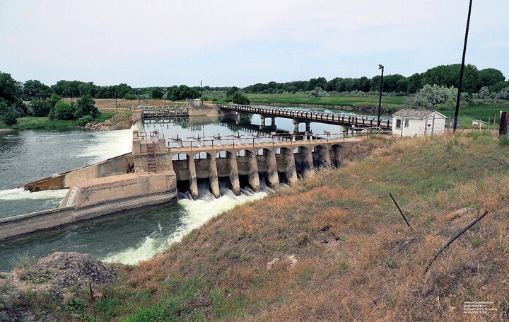
Figure 4. Whalen Diversion Dam on the North Platte River, Goshen County, Wyoming.
The Whalen Diversion Dam is located downstream approximately eight miles from Guernsey Dam. At this gravity, concrete ogee weir diversion dam, water is diverted to both the north and south sides of the river into two canal systems down the North Platte River valley in Wyoming and Nebraska. These two main line canals follow the contours of the valley to irrigate approximately 340,000 acres through a series of smaller canals and laterals.
The south canal, called the Goshen/Gering-Fort Laramie canal, comprised of two separate irrigation districts sharing the main canal. The Goshen Irrigation District is on the Wyoming side and the Gering-Fort Laramie Irrigation district is on the Nebraska side. The capacity of this main line canal is approximately 1450 cubic feet per second (cfs or “second feet”) and about 129 miles in length. Canal construction was from 1915 through 1924. This canal has three tunnels, which tunnel No. 2 collapsed in 2019 during the critical period for crop water demand. (Visit the Canal Irrigation section for more information.)
The north canal is the Interstate canal, now called the Pathfinder Canal. The capacity of the canal is approximately 2,100 cfs. The canal was constructed during 1905-1915 and is 95 miles long to the inland lakes. The “inland lakes” — Big Lake Alice, Little Lake Alice, Winters Creek Lake, and Lake Minatare — serve as water storage for the 35-mile long High-Line canal and the 43-mile long Low-Line canal. These lakes are located northeast of Scottsbluff, Nebraska. The combined capacity of the lakes is approximately 73,000 acre-feet.
Still the question from my Water Law 101 series, what is water worth?
References
Autobee, Robert, “North Platte Project,” Bureau of Reclamation, 1996
The National Park Service, “History of Guernsey Dam,” WyoHistory.org, 2014
The National Park Service, “Pathfinder Dam,” WyoHistory.org, 2014
