Current Conditions
February started with a winter storm for the record books for many locations in Nebraska. Portions of southern, central, and northeastern Nebraska saw snow amounts well above 12-15 inches accompanied by strong winds with gusts over 45 mph. This led to closure of roads, schools, and businesses, as well as a lot of hard work for individuals caring for animals or calving cows.
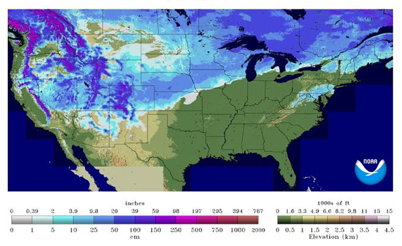
Figure 1 shows the current snow depth and the wide coverage area of the recent storm as it moved from southern Colorado through our area and into Wisconsin. This snow cover will stick around for a while due to the large amounts that fell across the state. On the positive side, the storm provided a protective blanket over the winter wheat and, in one event, provided enough moisture to meet normal monthly precipitation levels for most locations.
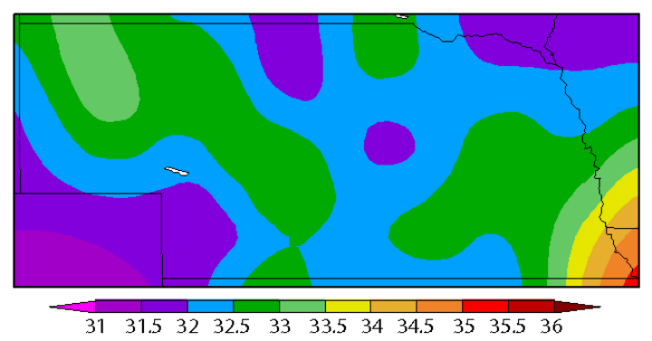
Currently, soil temperatures at a depth of four inches are still above freezing for most of Nebraska (Figure 2). Soil temperatures are 3-4 °F above normal in northwest and northeast Nebraska. The current snow cover will likely keep these soil temperatures fairly steady over the next couple weeks. Air temperatures have been near normal for January after a very warm December, which has allowed the soil to stay moderately warm.
Looking Forward
The main weather feature coming up will be the seasonably cool temperatures next week. A trough will settle in over the eastern U.S. and will allow cold air from Canada to move into Nebraska most of next week. The coldest temperatures will be in eastern Nebraska with warmer temperatures in the west and southwest. Highs are expected to be primarily in the 30s with a few 40s in the west. Right now, the models keep the very cold, sub-zero temperatures east of Nebraska, but a shift in the trough axis could bring those very cold temperatures to eastern Nebraska. This means the large amount of snow that fell this past week will most likely stick around for a while. There will be some melting, but temperatures will not remain warm enough for an extended time to melt much snow.
On the precipitation side, it doesn’t look like we will be getting any new snow accumulation in the near future and are expected to remain relatively dry through next week. If the trough expected to settle in over the Great Lakes does shift back west, this could increase our chances for precipitation, however this remains unlikely.
, http://www.cpc.ncep.noaa.gov/products/predictions/long_range/lead14/.)
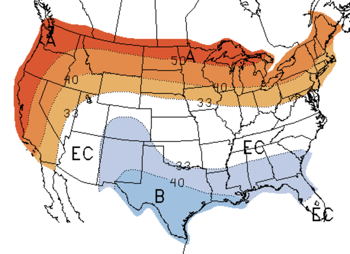
The forecast for February from the Climate Prediction Center (CPC) shows higher odds for above normal precipitation with no signal for temperature (Figure 3). This forecast was released on January 31 and most likely took into account the large winter storm that was to move through Nebraska on February 1-2. So, the key question is: Have we seen the bulk of our precipitation for the month or is more to come? Odds will tell you that we are not done, but it sure looks like the next week or so will be dry.
It is challenging to predict much further out than that, but the models do suggest a pattern shift shortly after Valentine’s Day. You probably won’t notice the pattern shift, but the trough in the eastern U.S. is expected to move out and high pressure will settle in over the central U.S. This would suggest a gradual warm-up with sunny, dry, and somewhat cool weather would prevail the third week of February. The 8-14 day outlook (Feb. 12-18) released by the CPC February 5 shows increased odds for above normal temperatures and below normal precipitation for the western half of the U.S., including Nebraska. The forecast model for the last 10 days of February suggest that a trough may build back in over the eastern U.S., and possibly drop our temperatures and bring in precipitation. The confidence in any forecast this far in advance is very low and I’m merely pointing out what the long-term models are showing. However, I am confident that this next week won’t be our last bout of cold weather.
, http://www.cpc.ncep.noaa.gov/products/predictions/long_range/lead1/)
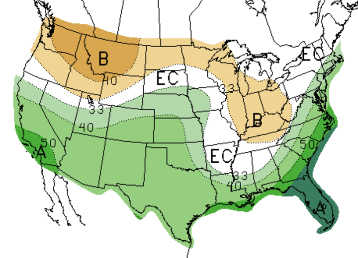
The three-month outlook through April has remained unchanged for a while. It is still expected that above normal temperatures in the northern half of the U.S. and above normal precipitation in the southern half will prevail as the dominant features through the first month or two of spring. This is in large part due to the diminishing El Nino, which will still impact our weather well into the 2016 spring season.
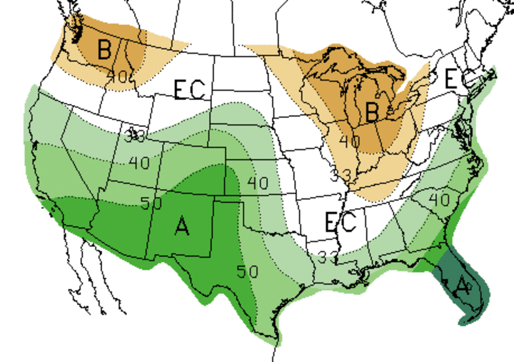
With all that said, confidence remains high that we will have adequate soil moisture for planting, with a concern that there may be too much soil moisture to enter the field. As you can see in Figure 4, dry areas are expected in the Great Lakes/Eastern Corn Belt regions. There are two things to consider with this map:
- This dry area could shift west and provide necessary drying for planting in Nebraska.
- This dry area may provide ideal planting conditions for the eastern Corn Belt and have a marketing impact.
There is always the possibility that it could be completely wrong, but it is worth watching.
