
Editor's note: This article is the second in a three-part series explaining how Endangered Species Act (ESA) requirements affect pesticide applications in Nebraska. Part 1 introduces the regulatory background and outlines current label requirements for products such as Enlist One® and Liberty® ULTRA. Part 2 focuses on runoff and erosion mitigation strategies. Part 3 addresses ecological spray drift mitigation.
What Applicators Should Know
Runoff and erosion mitigation is required when applying Enlist One® or Liberty® ULTRA, and applicators must earn a minimum number of mitigation points before spraying.
Soil type determines the point requirement for Enlist One®:
HSG A or B soils — “4” points
HSG C or D soils — “6” points
Most eastern Nebraska fields fall into the higher-requirement group.
Enlist One® mitigation options are listed directly on the product label, allowing applicators to meet requirements using familiar conservation practices such as no-till, cover crops, terraces or vegetative buffers.
Liberty® ULTRA mitigation requirements are not listed on the label and require checking EPA’s Mitigation Menu and Bulletins Live! Two. Mitigation applies statewide unless field-specific exemptions are met.
Common Nebraska practices often meet mitigation thresholds, including no-till, reduced tillage, terraces, vegetative filter strips and cover crops — many operations may already have sufficient points in place.
County-level runoff vulnerability may reduce point requirements in some regions, but eastern Nebraska generally receives fewer mitigation relief points.
For users of Enlist One® (manufacturer label) or Liberty® ULTRA (manufacturer label and supplemental label – expires March 19, 2027), implementing runoff and erosion mitigation practices based on their fields’ characteristics and cropping practices is necessary to comply with the label and the Endangered Species Act (ESA) requirements.
For Enlist One®, Nebraska currently has no designated Pesticide Use Limitation Areas (PULA), but users should check Bulletins Live! Two (BLT) per the label requirement. The Nebraska Department of Agriculture recommends saving or printing the bulletin for an application site, even if there are no restrictions for the location, product and month combination. The number of runoff/erosion mitigation points required depends on the Hydrologic Soil Group (HSG). Fields with HSG A or B (sand, loamy sand or sandy clay loam) must achieve a minimum of “4” points, while fields with HSG C or D (loam, clay loam, or silty clay soils, typical in eastern Nebraska) must meet a “6”-point threshold.
Applicators should confirm soil groups using the Natural Resources Conservation Service (NRCS) soil maps for the location where the application will occur or by consulting local technical resources. The Nebraska Department of Agriculture developed guidance for using the Web Soil Survey to find soil groups for your fields (access guidance materials).
An important exception to note is that runoff and erosion mitigation requirements were implemented for the Enlist® products before the U.S. Environmental Protection Agency’s (EPA) official ESA strategies were finalized; therefore, all currently available mitigation measures are listed on the product label for Enlist One® (Table 1) instead of directing users to the online Mitigation Menu.
Mitigation Measures | Details | Credits | |
| Reduce number of applications* | 3 applications | 0 | |
| 2 applications | 2 | ||
| 1 application | 4 | ||
| Residue Tillage Management: No-till, strip-till, ridge-till, and mulch-till | 4 | ||
| Vegetative Filter Strips | 30 ft off-field vegetative buffer on down slope | HSG A or B | 2 |
| HSG C or D | 0 | ||
| 100 ft off-field vegetative buffer on down slope | HSG A or B | 4 | |
| HSG C or D | 1 | ||
| Field Border: Border with dense vegetative stands with a minimum width of 30 ft | 2 | ||
| Cover Crop | 2 | ||
| Vegetative Barrier: Permanent strips of dense vegetation along the contours of the field with a minimum width of 3 ft | 2 | ||
| Contour Buffer Strips or Terrace | 2 | ||
| Grassed Waterway | 2 | ||
| Water and Sediment Basin | 1 | ||
| Contour Farming or Contour Strip Cropping | 1 | ||
| *Reduced number of applications of Enlist products per year. Applications may be made at any time during crop development but must maintain a minimum 12-day retreatment interval. | |||
Hydrologic Soil Group (HSG) definitions: A = Sand, loamy sand, or sandy loam | |||
For Liberty® ULTRA or associated alternate brand names in Nebraska, there are currently no designated PULA, but users should still check Bulletins Live! Two (BLT) per the label requirement. The Nebraska Department of Agriculture recommends saving or printing the bulletin for an application site, even if there are no restrictions for the location, product and month combination. Label-required runoff and erosion mitigation applies statewide unless field-specific exemptions are met. Unlike Enlist One®, where mitigation options are listed directly on the label, the Liberty® ULTRA label requires applicators to use EPA’s Mitigation Menu to determine applicable measures. Applicators must earn a minimum of “3” points using EPA-approved practices.
Table 2 summarizes feasible practices suited to Nebraska’s field conditions and available equipment to meet requirements where mitigation remains mandatory.
| Mitigation Measure | Points | Adoption Level | Notes | |
|---|---|---|---|---|
Planning and Documentation Measures | ||||
| Plan from Certified Technical Specialist | 1 | Available through NRCS and private consultants | Requires a credentialed advisor with runoff mitigation training. | |
Mitigation Tracking (Field-level documentation) | 1 | Widely qualifying | Easy to implement with paper or electronic field records (e.g., spray logs, apps). | |
Field Characteristics and Soil-Based Measures | ||||
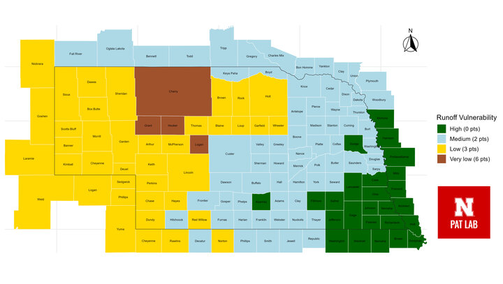
| Mitigation Relief Based on Runoff Vulnerability (Figure 1) | 0 to 6 | Field- and region-dependent | Points assigned based on mapped runoff vulnerability (very low = 6; low = 3; medium = 2; high = 0). | |
| Field Slope ≤3% | 2 | Widely qualifying | Many fields in Nebraska meet slope requirements naturally and/or with leveling. | |
| Sandy Soils (HSG A/B) | 2 to 3 | Region dependent (west/central NE) | Based on NRCS soil classification. 2 pts = HSG B (10–20% clay); 3 pts = HSG A (≤ 10% clay, ≥ 90% sand); cannot be used if label prohibits applications on sandy soils. | |
In-field and Field-adjacent Mitigation Measures | ||||
| No-till (including perennial crops such as orchards that are not tilled) | 3 | Widely adopted | Common practice across most Nebraska row-crop systems; maximizes residue cover and minimizes erosion. | |
| Reduced tillage, strip tillage, ridge tillage, or mulch tillage | 2 | Widely adopted | Frequently used in central and western Nebraska; supports soil conservation while accommodating planting needs. | |
| Terrace Farming | 2 | Common on sloped fields | Terrace or field terracing reduces water velocity and erosion; often permanent infrastructure. | |
| Contour Farming | 2 | Common on sloped land | Contour farming, contour tillage, or contour perennial crop systems reduce slope length and runoff. | |
| Cover Crop or Continuous Ground Cover | 1 to 3 | Moderate to growing adoption
| Points vary by intensity and duration: 1 pt = with tillage, 2 pts = short-term no-till, 3 pts = long-term no-till. Provides surface protection, reduces erosion, and improves soil organic matter and structure. Adoption is expanding in irrigated and eastern systems but remains limited in dryland rotations due to moisture and establishment challenges. | |
Irrigation Water Management | ||||
| Soil-moisture or evapotranspiration sensors, micro-sprinklers, or surface drip systems | 2 | Widely feasible | Improves water-use efficiency and minimizes surface runoff in irrigated systems. | |
| Subsurface drip, dry farming, or non-irrigated lands | 3 | Regionally feasible | Eliminates or reduces surface runoff; applicable where precipitation limits water availability | |
| Grassed Waterway | 2 | Regionally used | Established along drainage paths; reduces gully formation and promotes sediment settling. | |
| Vegetated Ditch | 1 | Regionally used | Reduces transport of sediment and runoff; typically constructed along field drainage outlets. | |
| Vegetative Filter Strips or Field Border Adjacent to Field | 20 to 30 ft | 1 | Field-specific | Provides limited filtering; feasible along field edges where space is constrained. |
| 30 to < 60 ft | 2 | Field-specific | Moderately effective at capturing sediment and nutrients. | |
| ≥ 60 ft | 3 | Site-specific | Highest performance; permanent vegetation downslope of treated area required. | |
Application Mitigation Measures | ||||
| Annual Application Rate Reduction | 1 to 3 | Feasible with planning | Viable in fields with reduced weed pressure or integrated control programs. Rate reduction of 10 to <30% (1 pt), 30 to <60% (2 pts), and ≥60% (3 pts). | |
| Reduction in field treated (banded, partial area treated, precision sprayers, smart (targeted) sprayers) | 2 to 4 | Growing adoption | Requires mapping and technology; conventional or pulse width modulation applied fields qualify with a treated area reduction. Reduction in area 10 to <30% (2 pts), 30 to <60% (3 pts), and ≥60% (4 pts). | |
Cross-Category Mitigation Coordination | ||||
| Using Mitigation Measures from Multiple Categories | 1 | Widely qualifying | Applicators may combine practices from at least two categories: in-field, field-adjacent, or systems capturing runoff and discharge. Examples include (1) one in-field + one field-adjacent measure, (2) one in-field + one runoff-capture system, or (3) one field-adjacent + one runoff-capture system. Encourages integrated planning that enhances cumulative mitigation effectiveness. | |
In most cases, achieving the required runoff mitigation threshold is attainable, with the current maximum worst-case scenario requiring a total of “9” points. However, ensuring adequate consideration of measure integration within existing farm operations remains essential. Where program constraints or label requirements differ, less restrictive mitigation crop protection programs may be substituted, provided they meet EPA performance expectations.
Helpful Resources
- Nebraska Department of Agriculture Supplemental Materials
- CropLife America’s Adapting to ESA: Runoff Instructional Video
To the best of our knowledge, and based on the available information, this summary accurately reflects the current regulations, mitigation requirements and product label guidance as of Nov. 17, 2025. Regulations and label instructions continue to evolve, and amendments will be made as necessary to incorporate the most up-to-date information as it becomes available. Tools such as hardcopy worksheets, spreadsheet calculators and the Pesticide App for Label Mitigations (PALM) web-app are available to assist applicators in documenting runoff and drift mitigation requirements. However, their applicability depends on the specific directions and limitations provided on each product label.
All referenced materials are cited and provided either as hyperlinks or as supplemental resources for the convenience of end users. These resources have been compiled strictly for educational and informational purposes. No proprietary content is claimed, and all materials remain the property of their respective owners.
Thank you to the Nebraska Corn Board for supporting this series of articles (Project #88-R-2526-10) and to CropLife America for granting permission to repurpose select educational materials.
