Rain Next Week
I’m on travel this week so the update is short and sweet. It has been a very dry start to the month thus far with many places in the state having received no precipitation. Outside of slight chances for moisture Saturday morning, Sept. 14, it will likely remain dry across the state for much of the state for another several days. But things start to change early next week. By next Tuesday, Sept. 16, troughing in the western U.S. will make its way toward the Northern Plains and there will be chances for showers and thunderstorms starting Tuesday night in western Nebraska and across central and eastern Nebraska by Wednesday morning, Sept. 17.
Additional disturbances will be moving into the Central Plains later in the week, which will lead to multiple chances for additional precipitation, especially across south-central and eastern sections of Nebraska. A look at the ECMWF ensemble reveals a better than 50/50 shot for over an inch of moisture for most of eastern and central sections of Nebraska by next Saturday evening, Sept. 21. Regarding an event next Friday evening, Sept. 20 in Lincoln, it may be wet. Recommend paying attention to the forecast and plan accordingly.

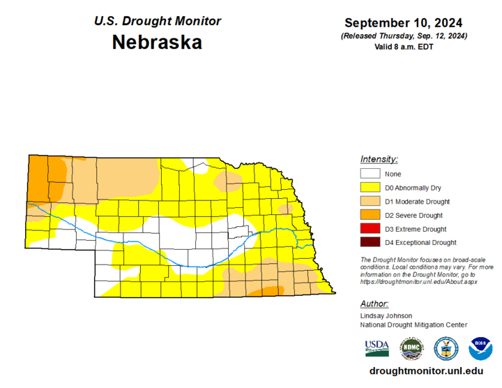
Drought Update
Any precipitation next week will be welcome across the state as drought has already arrived for a bit over 25% of the state and is knocking on the doorstep for roughly half the state. Sarpy County and large portions of central and southwestern Nebraska are free and clear of drought and abnormal dryness on the latest U.S. Drought Monitor. But over the past month, a large portion of the state has seen at least a 1-category level of degradation and additional degradation may be coming next week before our rain chances increase.

