Part 4 of a six-part series that will cover the major rivers and their respective drainages found in Nebraska, with some geography and history about Nebraska’s rivers.
Related Articles:
- Part 1: The Big Blue, Little Blue and Nemaha Rivers
- Part 2: The Elkhorn and Missouri Rivers
- Part 3: The Loup River
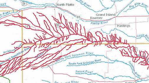
- Part 4: The Republican River
- Part 5: The Platte Rivers
- Part 6: The Niobrara River, White River and Hat Creek
Nebraska is blessed with abundant water, with many streams, rivers and groundwater. At times these rivers flood, creating unbelievable devastation. This finite resource of abundant, clean water serves to irrigate over nine million acres of crops across the state, provides for our daily needs, riparian habitat for wildlife and fauna, a multitude of recreational opportunities, and aesthetics for the soul. Safe and respectful use of this essential resource is incumbent on all of us.
The Republican River
The Republican River drainage system is in south/south-central Nebraska. The headwaters of the Republican are in east-central and northeast Colorado. The Republican joins with the Kansas River northeast of Junction City, Kansas. The Republican River flows for approximately 453 miles with an average discharge of 848 cubic feet per second (cfs) at the confluence with the Kansas River. The Republican River has numerous branches that form the river, including the North and South Republican Rivers, Arikaree River, Frenchman, Red Willow, Medicine, Beaver, Sappa, and Prairie Dog creeks. The Republican River is named after the Kitkehahkis Pawnee Native Americans.
The Republican River has flooded many times. The most recent flood occurred in late May 1935. During this flood, waters were reported to running bluff to bluff. Two days after the flood waters subsided, 94 lives and substantial property damage were lost. The National Weather Service lists this flood as the worst in Nebraska history.
There are numerous U.S. Bureau of Reclamation Pick-Sloan Missouri Basin Projects, including the Frenchman-Cambridge Division dams. Many of these dams and reservoirs are also state recreational areas managed by the Nebraska Game and Parks Commission.
The Trenton Dam/Swanson Reservoir is on the Republican River. It is located west of Trenton, Nebraska. The dam and reservoir were constructed for irrigation and flood control. The reservoir has a surface area of 4,974 acres and 112,214 acre-feet of water capacity.
Enders Dam and Reservoir are on Frenchman Creek south of Enders, Nebraska, and part of the Enders Reservoir State Recreation Area. The dam and reservoir were constructed for irrigation and flood control. The reservoir has a capacity of 44,480 acre-feet of water. Irrigation water releases were halted in 2002 because of reduced inflows from Frenchman Creek, which were due to the lowering of the water table from groundwater irrigation. The reservoir, dam and adjoining land form the Enders Reservoir State Recreation Area. The dam is owned and operated by the U.S. Bureau of Reclamation.
Red Willow Dam and Hugh Butler Lake/Red Willow Reservoir are on Red Willow Creek, north of McCook, Nebraska, and part of the Red Willow State Recreation Area. The dam and reservoir were constructed for flood control. The lake/reservoir has a surface area of 1,629 acres and a capacity of 36,200 acre-feet of water.
Medicine Creek Dam and Harry Strunk Lake/Reservoir are on Medicine Creek, north of Cambridge, Nebraska, and part of the Medicine Creek Reservoir State Recreation Area. The dam and reservoir were constructed for flood control. The lake/reservoir has a surface area of 1,850 acres and a capacity of 34,647 acre-feet of water.
Harlan County Reservoir and Dam is located between Alma and Republican City, Nebraska. The dam was constructed by the U.S. Army Corps of Engineers, which administer the public and recreational lands comprising the 17,750-acre area. The reservoir has a surface area of 13,250 acres and a maximum capacity of 840,561 acre-feet of water, of which 193,060 acre-feet of water are allocated for irrigation, and 508,989 acre-feet are allocated for flood control. The balance is for dead capacity or inactive. The reservoir is the second largest in the state. The dam and reservoir were constructed for flood control and irrigation, part of the Bostwick Division.
The Bostwick Division is part of the U.S. Bureau of Reclamation Pick-Sloan Missouri Basin Project. Waters from Harlan County Reservoir and Lovewell Reservoir (Kansas) irrigate approximately 102,787 acres. Nebraska has 22,787 acres, split into the Franklin unit, 14,944 acres, and the Superior-Cortland unit, 7,843 acres. The Franklin unit irrigated area is served by the Franklin and Naponee canals and the Franklin South Side Pump Canal. These canals divert water directly from the Harlan County Dam. The Superior-Courtland unit diverts water from the Republican River from a diversion dam west of Guide Rock, Nebraska.
The Kansas-Bostwick area irrigates approximately 80,000 acres, 18,000 acres in the Scandia Unit, and 62,000 acres in the Courtland Unit. The Courtland Canal fills the Lovewell Dam and Reservoir.
Bonny Dam and Reservoir are located on the south fork of the Republican River in Colorado. It is part of the U.S. Bureau of Reclamation Pick-Sloan Missouri Basin Project Armel Unit. The dam and reservoir were constructed for flood control and have a total capacity of 343,558 acre-feet water. In 2011, the State of Colorado drained the reservoir to meet its obligations under the Republic River Compact with Kansas and Nebraska. The reservoir remains drained, with the river flowing through the outlet structure and occasionally drying up in the summer months. Limited recreational opportunities are still available.
The primary crops grown in this area are corn, soybeans, grain sorghum, alfalfa, forages and small grains.
Colorado, Kansas and Nebraska share the Republican River waters and its use. How the water is divided and used is determined by the Republican River Compact. The compact and other compacts and decrees Nebraska has can be found online.
There are four Natural Resource Districts (NRDs) combined that cover this drainage in Nebraska. They are the Upper, Middle and Lower Republican NRDs and part of the Tri-Basin NRD. The total combined area of these NRDs is 8,992 square miles.
To view these river drainages, and others across the United States, the United States Geological Survey (USGS) has a great website called Streamer. At the website, click “Go to Map.” From the new page, zoom in on the state. In the upper right corner of the page, click “Trace Upstream.” Zoom in and find the point you want to trace the river/stream upstream. To see the Republican River Drainage, click on the river at the confluence with the Kansas River Near Junction City, Kansas. If you know the river/stream headwaters/source, you can also use the “Trace Downstream” feature.
