Part 3 of a six-part series that will cover the major rivers and their respective drainages found in Nebraska, with some geography and history about Nebraska’s rivers.
Related Articles:
- Part 1: The Big Blue, Little Blue and Nemaha Rivers
- Part 2: The Elkhorn and Missouri Rivers
- Part 3: The Loup River
- Part 4: The Republican River
- Part 5: The Platte Rivers
- Part 6: The Niobrara River, White River and Hat Creek
Nebraska is blessed with abundant water, with many streams, rivers and groundwater. At times these rivers flood, creating unbelievable devastation. This finite resource of abundant, clean water serves to irrigate over nine million acres of crops across the state, provides for our daily needs, riparian habitat for wildlife and fauna, a multitude of recreational opportunities and aesthetics for the soul. Safe and respectful use of this essential resource is incumbent on all of us.
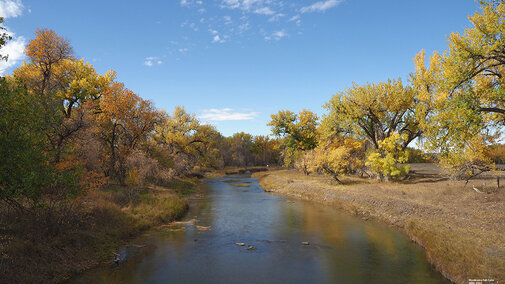
The Loup River
The Loup River drainage system is in central Nebraska. The headwaters of the Loup are in the central and eastern Sandhills. The Loup River flows for approximately 290 miles and joins with the Platte River southeast of Columbus, Nebraska. The river has an average discharge of 2,584 cubic feet per second (cfs) at the confluence with the Platte River. The Loup River has three major branches — North, Middle and South Loup. Numerous tributaries feed the Loup, including Dismal River, Calamus River, Clear Creek, Cedar Creek, Beaver Creek and others.

The Loup River was the second major river crossing the Mormons made on their trek west to Salt Lake City, Utah. The initial crossing was near Fullerton, Nebraska, and subsequent crossings were near Palmer, Nebraska. The Loup River drainage serves as a recreational site for boating, fishing, hiking trails and other recreational activities, as well as water for irrigation.
There are three reservoirs in the Loup River drainage. These include Sherman Reservoir, located on Oak Creek, northeast of Loup City, Nebraska. Sherman Reservoir is part of the U.S. Bureau of Reclamation Pick-Sloan Missouri Basin Project, Middle Loup Division, Farwell Unit. Water is diverted at the Arcadia Diversion Dam located on the Middle Loup River into the Sherman Feeder Canal, which feeds the reservoir. The dam and reservoir were originally constructed for flood control and irrigation. Water delivered from the reservoir through a series of laterals and canals irrigates approximately 49,000 acres of corn, soybeans and alfalfa. The Farwell Irrigation District and the Loup Basin Reclamation District own the dam. Sherman Reservoir is also a Nebraska Game and Parks state recreation area that includes the 2,845-acre lake with a capacity of 69,076 acre-feet of water and 4,721 acres of adjacent land for a multitude of recreational opportunities.
The second reservoir is the Davis Creek dam and reservoir located on Davis Creek, south of North Loup, Nebraska. Davis Creek is part of the U.S. Bureau of Reclamation Pick-Sloan Missouri Basin Project, North Loup Division. The dam was constructed for flood control and operated by the Twin Loups Irrigation District. Water is supplied from the Calamus Reservoir by the Twin Loup Irrigation District Mirdan Canal. Davis Creek reservoir has a surface area of 1,145 acres and 31,158 acre-feet of water capacity. The dam and reservoir are part of the Davis Creek State Wildlife Management and Recreation Areas.
The third reservoir is Calamus Reservoir and Virginia Smith/Calamus Dam, located on the Calamus River northwest of Burwell, Nebraska. The dam is part of the U.S. Bureau of Reclamation Pick-Sloan Missouri Basin Project, North Loup Division. The dam was constructed for flood control and irrigation. It is operated by the Twin Loup Irrigation District. The reservoir has a surface area of 5,142 acres and a capacity of 124,400 acre-feet of water. The reservoir and surrounding land form the Calamus Reservoir State Recreation and Wildlife Management Areas, managed by the Nebraska Game and Parks Commission.
The Sargent Unit of the U.S. Bureau of Reclamation Pick-Sloan Missouri Basin Project, Middle Loup Division, consists of the Milburn Diversion Dam located on the Middle Loup River, northeast of Anselmo, Nebraska. Water from the diversion dam irrigates approximately 14,000 acres on the north side of the Middle Loup River through the Sargent Canal and Lateral. Loup Basin Reclamation has the responsibility for the operation and maintenance of the dam and canal system while Sargent Irrigation has the responsibility for the distribution of water and the drainage system. The Milburn Wildlife Management area is managed by the Nebraska Game and Parks Commission.
The Kent Diversion Dam is located on the North Loup River and is part of the U.S. Bureau of Reclamation Pick-Sloan Missouri Basin Project and is used to divert and desilt water from the river into the Kent Canal. The Kent Diversion Dam is also a state wildlife management area managed by the Nebraska Game and Parks Commission.
Primary crops grown in this area include corn, soybeans, alfalfa, forages and small grains.
There are two Natural Resource Districts (NRDs) combined that cover this drainage. They are the Upper and Lower Loup NRDs. The total combined area is 14,602 square miles.
To view these river drainages and others across the United States, the United States Geological Survey (USGS) has a great website called Streamer. At the website, click “Go to Map.” From the new page, zoom in on the state. In the upper right corner of the page, click “Trace Upstream.” Zoom in and find the point you want to trace the river/stream upstream. To see the Loup River Drainage, click on the river at the confluence with the Platte River near Columbus, Nebraska. If you know the river/stream headwaters/source, you can also use the “Trace Downstream” feature.
