Patricio Grassini, UNL Associate Professor of Agronomy and Horticulture, Extension Cropping System Specialist and Water for Food Institute Fellow; Jose Andrade, UNL Affiliate; Juan Ignacio Rattalino Edreira, UNL Research Assistant Professor of Agronomy and Horticulture; Gonzalo Rizzo, UNL PhD student; Haishun Yang, UNL Associate Professor of Agronomy and Horticulture and Water for Food Institute Fellow; Keith Glewen & Jennifer Rees, Nebraska Extension Educators; Jeff Coulter, Professor and Extension Specialist, University of Minnesota; Mark Licht (Extension Cropping System Agronomist) & Sotirios Archontoulis (Assistant Professor), Iowa State University; Ignacio Ciampitti, Crop Production and Cropping System Specialist and Assistant Professor of Agronomy, Kansas State University; Ray Massey, Extension Professor, University of Missouri
Simulations of 2020 end-of-season corn yield potential and real-time crop stage were performed on August 4 for 40 locations across the US Corn Belt using the UNL Hybrid-Maize crop model in collaboration with faculty and extension educators from ten universities. This article summarizes the simulated crop stages and yield forecasts; the data can be downloaded here. Details on the UNL Hybrid-Maize crop model and the underpinning methodology to simulate phenology and forecast end-of-season yields, as well as on interpretation and uses of yield forecasts, are described in a previous article. Note that one location in IA (Kanawha) was not included for the forecasts due to lack of weather data.
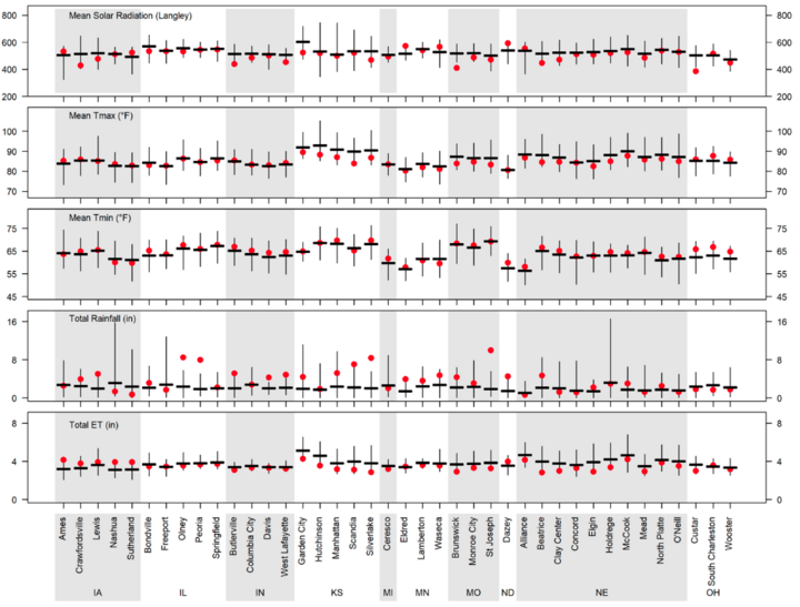
During the last three weeks, air temperature tended to be near the historical average in most of the Corn Belt, with a few sites showing values below (KS) or above (OH) the historical average. In the case of rainfall, most locations exhibited near-normal rainfall, except for northern IA (rainfall below normal) and KS, southeastern NE, and northwestern MO (rainfall above normal). A summary of weather conditions during the last three weeks is shown in Figure 1.
Simulated Corn Stage Across 40 Locations
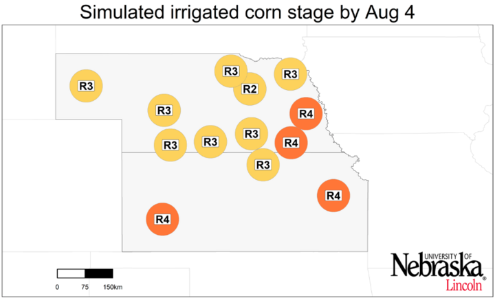
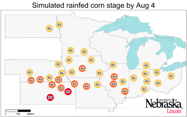
Most locations are running ahead last year’s corn development. Corn has reached kernel milk stage in almost the entire Corn Belt, except for one site in northern NE where it is still in blister stage. Most sites in the southern fringe of the region (MO, KS, and southern IL) are ahead of the rest of the locations where corn has reached the dough or kernel dent stage (Figure 2).
Irrigated Corn: High Probability of Near-average Yields
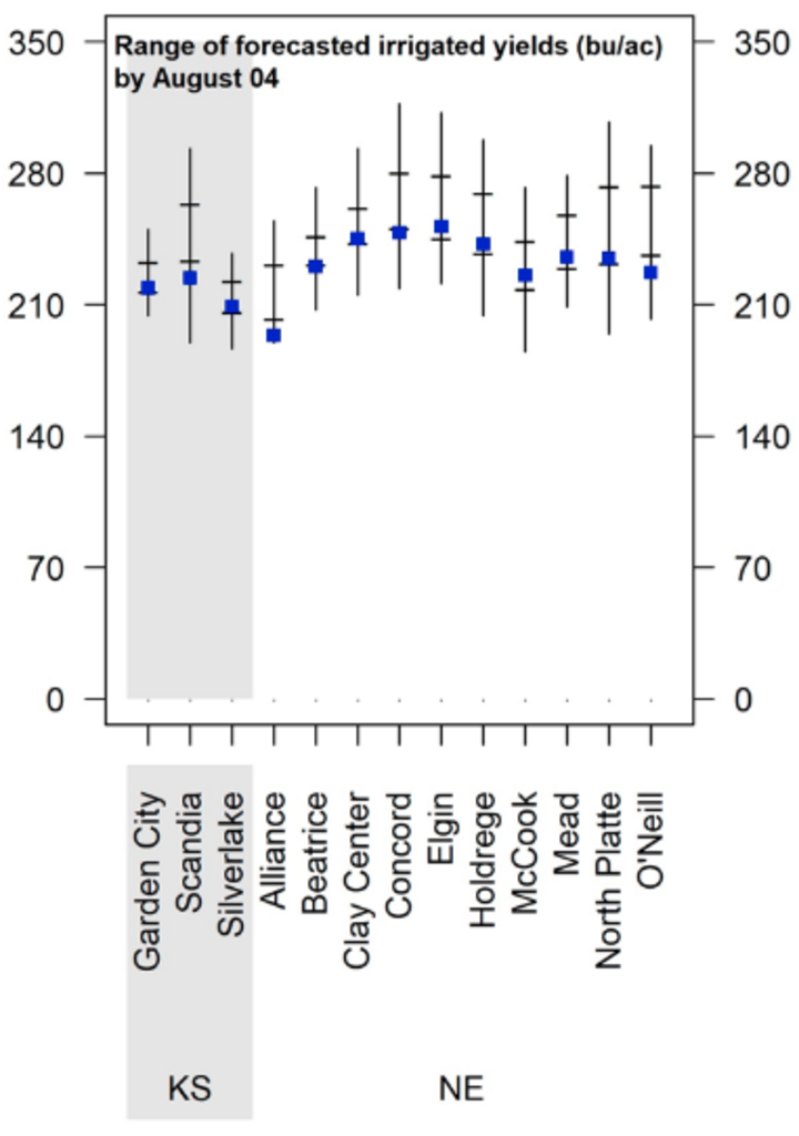
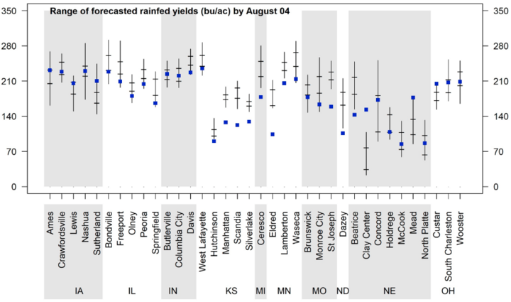
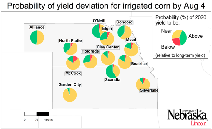
The range of forecasted irrigated corn yield potential for each location, as well as the probabilities for yields above, near, or below average, are shown in Figures 3 and 4. Five out of 13 sites exhibit a high probability (>75%, that is, a chance of 3 out of 4) of near-average yield potential. Favorable weather during the rest of the season that results in a long grain-filling period may increase the likelihood of above-average yield. The chance of below-average yield is very low across all irrigated sites. At this point, the forecasted scenario for irrigated maize in the current season seems very similar to the 2019 forecasts, with less than ±5% yield variation in 10 out of 13 sites.
Variable 2020 Forecasted Corn Yield Across Rainfed Locations
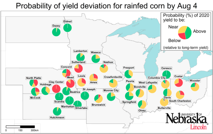
Forecasted yield potential is highly variable across the 36 rainfed sites (Figures 3 and 4). There is a high probability of above-average yield (>75%) at 12 sites in the northern (MN, ND, and MI) and southern fringes of the Corn Belt (KS, MO, southeastern NE, and southwestern IL), while only three sites have a high probability of below-average yields (south central and eastern NE and western IA). The scenario is also pessimistic for northwestern OH. Probability of near-average yield is relatively high in the central and eastern part of the Corn Belt (most of IA, IL, IN, and OH).
Compared with our previous forecast, above-average rainfall in KS, southeastern NE, and western MO during the past three weeks reduced the probability of below-average yield in that area, increasing the forecasted yield for the 2020 season. In contrast, near-average rainfall in south central and eastern NE was not sufficient to improve the below-average yield forecasted for rainfed maize in this region by mid-July. Compared with the 2019 forecast, the forecasted scenario for rainfed maize seems more pessimistic in NE, western IA, and northwestern OH in the current season, with yields 30% below those forecasted in 2019. In the remaining area, the scenario looks more optimistic (ND, MN, and southern OH) or similar to last year’s forecast.
Conclusions
Corn has already reached the milk stage, with most sites in the southern fringe of the region in dough or kernel dent stage. Similarly to our previous forecast, there is a high probability of near-average yields for the majority of the irrigated sites. For rainfed corn, the scenario is diverse across regions. Most sites in the central and eastern part of the Corn Belt have a high probability of near-average yields. Above-average yield is expected at 12 locations mostly located in KS, MN, ND, and MI. In contrast, three sites located in the eastern and south-central parts of NE and western IA exhibit a high probability of below-average yields. Temperature and rainfall during early Aug will likely define the trend for all sites across the region. These forecasts do not take into consideration problems with stand emergence, hail/flooding damage, replanting situations, disease, or nitrate leaching. In fields negatively affected by these constraints, actual yields will be lower than estimates provided here. It is important to keep in mind that yield forecasts are not field specific and, instead, represent an estimate of average on-farm yield for a given location and surrounding area in absence of the yield-reducing factors mentioned here. Likewise, crop stages and forecasted yields will deviate from the ones reported here in fields with planting dates or hybrid maturities that differ markedly from those used as the basis for the forecasts . We will follow up with further forecasts in late August.
