The recent string of weather events is definitely one for Nebraska’s history books. The key word to that sentence is “string” because it took a combination of patterns and extremes to get us to this point.
Beginning in mid-January, the weather pattern shifted from warm and relatively wet to a very cold and highly active pattern that brought snow, rain, and ice. This pattern lasted well into March. This almost 60-day period from mid-January to the March 13-14 storms and resulting flood will leave a lasting mark on Nebraska. Follow is a description of how this scenario developed.
Climatic Significance
One of the key components was the extended cold. Nebraska winters are often unpleasant; however, our continental climate and proximity to the Rocky Mountains typically provide some relief to extreme cold temperatures in the winter. However, from January 15 to March 10, northeast Nebraska only reached 32°F ten times. This number increased to almost 35 times as you moved south and west in Nebraska. To put this in perspective, in 2017 and 2018, northeast Nebraska hit the 32°F threshold on 42 and 28 days, respectively, during the same period. The normal maximum temperature for northeast Nebraska is in the upper 30s, so temperatures rarely reached normal.
The temperatures also dropped to extremely cold levels. The average minimum temperature for January 15 to March 10 was 0-5°F in northeast Nebraska (10-12°F below normal) and 10-12°F in southern and southwest Nebraska (4-6°F below normal). At one point in early March, minimum temperatures dropped to 20-25°F below zero in western Nebraska, with portions of eastern Nebraska dropping to near 20°F below zero.
Precipitation was another factor, especially for eastern Nebraska which was hard hit by flooding. Coming into this 60-day period, soils were saturated after eastern Nebraska saw at least 2.5 inches of precipitation from December 1 to January 15 (5 inches in portions of southeast Nebraska). This was 200%-400% of normal. Given this, any additional precipitation was likely to run off.
Starting in mid-January, snow covered portions of Nebraska and was intermittent through mid-February. This intermittent period of no snow cover allowed the very cold temperatures to freeze the soil to depths of 2-3 feet. In mid-February, a turbulent pattern moved in with numerous snow events, and the state stayed entirely snow covered from February 16 to March 13. East central Nebraska had more than 30 inches of snow from January 15 to March 10. Most of the rest of Nebraska received 15-20 inches of snow during that period.
The Bomb Cylcone
In early March, the forecast called for a “Bomb Cyclone” on March 13-14 in the Central Plains. This is also called “Bombogenesis” and some stations even named the event, Winter Storm Ulmer. Meteorologically, these are more frequently called mid-latitude cyclones and are typical in the cold season, as the warm air from the south clashes with the cold air from the north. The name Bomb Cyclone was attributed to this low-pressure system (mid-latitude cyclone) because the forecast was for the central pressure to drop 24 millibars (mb) in 24 hours. This rapid pressure decrease happens through bombogenesis and is most common over oceans or the east coast. It does appear, however, to look like a large hurricane over land and has similar attributes.
This cyclone had a surface pressure close to 970 mb in Kansas and is near (or may actually have been) a record low pressure for the area. This low pressure created a very tight pressure gradient, which created very windy conditions. The surface low pressure tracked up through Nebraska at a relatively slow pace. Due to the slow pace and rapid “spinning,” some locations experienced unpleasant conditions for an extended time. Fortunately, for our neighbors to the east, the slow pace of the system “wrung-out” the moisture, reducing its impact as it moved toward the Great Lakes.
Stage is Set
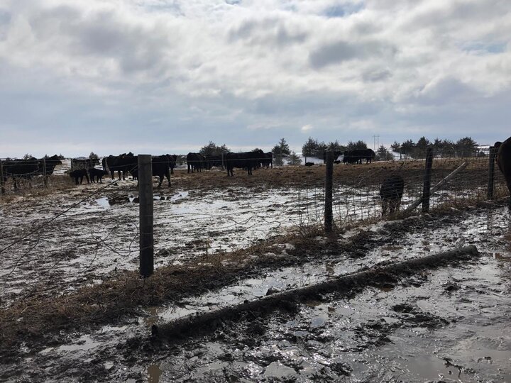
When this storm hit Nebraska, the state had already dealt with numerous wet and cold events, as mentioned early. The soils were saturated and frozen, rivers and lakes were covered by several feet of ice, and the state was blanketed by 5 to more than 25 inches of snowpack. Northeast Nebraska had the liquid equivalent of 2-4 inches of precipitation sitting on top of the surface in the form of snow, so the stage is set for the bomb cyclone to move in.
March 13-14 Event
On March 12 and 13 temperatures rose above freezing ahead of a deep trough, and started the snow melt. With saturated and frozen soil, none of this moisture could soak in. Precipitation began to move in with mostly rain in the eastern two-thirds of Nebraska and snow starting in the western third, with the push of cold air from the northwest. By March 14, snow had spread east and pushed all the way to near York. Blizzard conditions remained in western Nebraska for an extended time as they received 10-20 inches of snow. Portions of south central up through north central Nebraska received a couple inches of rain followed by 3-6 inches of snow. Gusts of 40-60 mph for two days worsened conditions.
The heaviest precipitation occurred from south central up through northeast Nebraska. Much of this 100-mile wide strip received at least 2 inches of liquid precipitation (some as snow), with local areas receiving more than 4 inches from Grand Island to Norfolk.
In most years, most months, and most scenarios, we can handle this type of precipitation; however, given the frozen soil, rapid snowmelt, and precipitation, it was like getting a 6-inch rainfall with zero infiltration. Even saturated (non-frozen) soils will infiltrate some liquid, but these soils did not. While it’s more complicated than just these three factors, this does help explain why this amount of precipitation had such an impact.
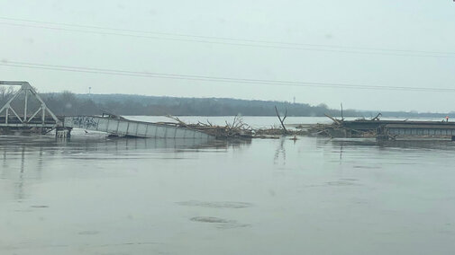
The rainfall fell on either snow or frozen soils, so the runoff had a slick “runway” to find its way to the lowest point. This rapid runoff eventually ended up in already swollen and frozen rivers. If the soils had not been frozen, we likely would have had more soil erosion, but with only lowland or moderate flooding. When the ice on the rivers started to break up, this clogged the rivers and enhanced the potential for more flooding. This ice also added weight to bridges and other structures in the path of the water, creating more stress.
Terrain also played a role as the flooding over areas with sizeable elevation differences over short distances was exaggerated by snow-filled ditches and culverts.
This 60-day period of abnormal weather was capped by historical flooding in central and eastern Nebraska, with unprecedented damage. It will take time and a little good luck from Mother Nature to recover from the “most challenging 60 days” for Nebraska weather.
Moving Forward
We should use this event to learn where the system failed so we can increase our resiliency for future events. For more information on how to help make your farm more resilient to Nebraska weather events, see Weather Ready Nebraska, a website of UNL's Institute of Agriculture and Natural Resources.
