The Nebraska State Climate Office has analyzed historical temperature and precipitation trends for the state’s eight climate divisions. This was performed for both the entire record length, which goes back to 1895, as well as the most recent three decades. These changes are placed in the context of climate projections, made available from the recent release of the 4th National Climate Assessment.
Temperature


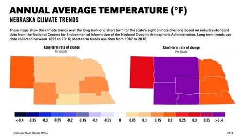
Nebraska’s climate has warmed over the last century. On average, temperatures have increased about 1.6 degrees Fahrenheit since 1895 (a rate of 0.15 degrees per decade). The rate of warming has generally increased over the last 30 years (0.3 degrees per decade), most notably for summer and fall. One exception to the warming in recent years is a cooling trend for the winter months where temperatures have cooled about one degree since 1987.
Overall, the rise of minimum temperatures is outpacing the rise in maximum temperatures by a factor of two. Lows have warmed 2.2 degrees while highs have warmed 1.1 degrees. Portions of Nebraska have experienced a slight long-term cooling trend in maximum temperatures during summer and fall. However, since 1987, the trend for summer and fall has been a warming trend of 1 degree.
Climate models project the overall warming trend will continue throughout this century. The rate of warming will accelerate in the coming decades. By mid-century average temperatures in Nebraska are expected to be 2 to 5 degrees warmer than they are now, increasing at a rate of 0.5-1.25 degrees per decade.
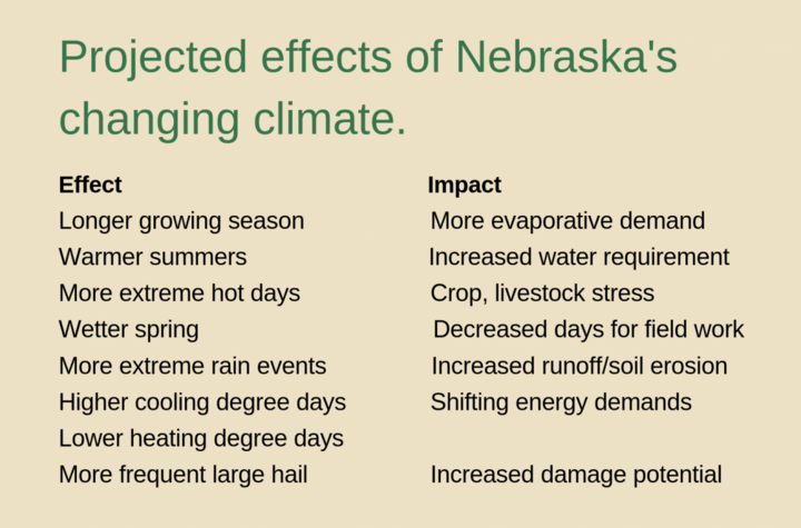
Nebraska experiences, on average, 10-20 days annually with a high temperature greater than 95°F. By mid-century, this number will likely double, impacting plant growth and development. Conversely, the number of extreme cold days will be cut by 50%-66%, on average.
The length of the growing season (number of days between last spring and first fall freeze) can be quite variable in Nebraska from year to year. On average, it is about 150 days. By mid-century, length of the growing season is expected to increase by several weeks.
Currently, modified growing degree days (base of 50°F) accumulated per year average 3,000-4,000 units. An increase of 20% to 25% can be expected by mid-century.
Given the temperature projections and warming trend, cooling degree days are projected to be 40% to 60% more than the current average (approximately 1,000 units). Heating degree days average about 7,000 units annually in today’s climate. By mid-century, projections indicate a 10% to 20% decrease.
Heating and cooling degree days are measures of heating and cooling requirements during the winter and summer, respectively, and are similar to a growing degree day unit. The base temperature is 65°F (for both heating and cooling) and are determined by accumulating the difference of the average daily temperature and 65°F.Precipitation
Nebraska’s precipitation patterns generally can be defined by high year-to-year variability and a strong east-west gradient where annual totals decrease by 50%. Through the 20th century our climate generally became slightly wetter with a precipitation increase of 1.3 inches (0.10 inch per decade). Much of this is a result of more precipitation during the spring (0.9 inch).
Trends over the last 30 years are amplified with an increase of 2 inches (0.67 inch per decade) in the annual average with much of that occurring during spring (1.2 inches). Portions of Nebraska have experienced a recent drying trend during summer, fall, and winter. The strongest trends haved occured in southern Nebraska where average annual precipitation has decreased by about one inch since 1987.
The climate model projections for precipitation point to a persistence of the wetting trend for the annual average total. We can expect our historical trend to continue with an increase in precipitation. There are expected to be changes, however, in when this precipitation falls. Winter and spring totals will be 15% to 25% higher than current conditions. Fall will be slightly wetter (5%) and summer will be 5% to 15% drier than the present climate, impacting summer irrigation demand.
Daily rainfall greater than one inch is generally not very common (less than five days a year) currently. However, we can expect a 15% to 35% increase in heavy precipitation days by mid-century. Furthermore, multi-day extreme precipitation events will increase in severity. Soil cover and structure will be critical to reduce runoff and increase the infiltration of excess precipitation.
Related to Nebraska’s water resources, Rocky Mountain snowpack has seen an overall decline in the last several decades. This trend is expected to continue with less snow water equivalence in addition to an earlier snowmelt altering the timing of peak streamflows in many Nebraska rivers.
There is inherent variability in Nebraska’s climate and the potential for back-to-back flood-to-drought years. As such, reservoir and groundwater storage are expected to become even more important to mitigate enhanced risk to future precipitation variability that lies outside of the range of past experience. Sustainable water management is therefore paramount.
