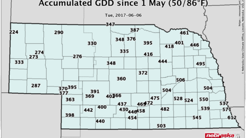
Above normal temperatures since June 1 have reduced accumulated Growing Degree Day (base 86/50) deficits incurred during the unseasonably cool weather that periodically has impacted the state since mid-April. Preliminary analysis suggests that GDD deficits based upon April 15, May 1, and May 15 emergence dates have been eliminated across the southern half of the state and reduced 15-25 units across the northern half of the state.
This GDD analysis doesn’t take into consideration the impact of planting delays on your operation and only looks at the impact of accumulated GDD surpluses or deficits from selected starting points. Just like last year, a cool May has given way to above normal temperatures during the opening week of June. The ultimate question is whether June 2016 temperatures will be replicated this year.
Lincoln reached the 90°F mark on June 2 and had a stretch of four consecutive days of 90°F or greater. After a brief cool down into the 80s, forecasts indicate three to four consecutive days of 90°F before a cold front pushes through the state on Tuesday (June 13). Last year, the first 90°F day occurred on June 8, which was the start of 12 consecutive days of 90°F or above in Lincoln. Six additional days of 90°F or greater highs were reported June 21-22 and 24-27. There were eight days above 95°F and two days above 100°F.
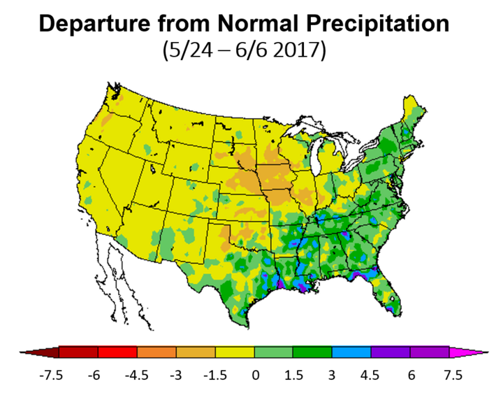
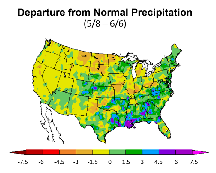
Coupled with the recent surge in temperatures, precipitation during the past 14 days has been below normal across the eastern half of the state (Figure 3). However, a wet trend is still firmly in place looking back 30 days, with only parts of the eastern Sandhills and northeast Nebraska depicting widespread dryness (Figure 4). Significant dryness at 30 days is apparent across the Dakotas, northwestern Minnesota, and southern portions of the central and eastern Corn Belt.
This current stretch of drier-than-normal conditions across the eastern third of the state has provided excellent drying weather for hay, but has been problematic for late-planted and replant crops in regard to surface crusting. On the positive side, warmer conditions have helped corn green up and should push rooting systems deeper in search of subsoil moisture. Hopefully, this brief return to the 90s will not cause heat stress related injuries to a young and developing corn crop like last year.
| 4/15 Emergence | 5/1 Emergence | 5/15 Emergence | ||||
|---|---|---|---|---|---|---|
| GDD | DIFF | GDD | DIFF | GDD | DIFF | |
| Ainsworth | 489 | -43 | 418 | -7 | 268 | -28 |
| Beatrice | 707 | 46 | 584 | 55 | 389 | 9 |
| Concord | 570 | -7 | 492 | 26 | 324 | -9 |
| Elgin | 558 | -1 | 479 | 31 | 312 | -4 |
| Gordon | 451 | -55 | 377 | -28 | 235 | -46 |
| Imperial | 570 | 6 | 469 | 25 | 306 | -1 |
| Kearney | 628 | 32 | 516 | 43 | 342 | 8 |
| McCook | 616 | 51 | 499 | 53 | 328 | 19 |
| Mead | 665 | 33 | 549 | 42 | 363 | 0 |
| North Platte | 575 | 25 | 475 | 40 | 305 | 4 |
| Ord | 543 | -30 | 455 | -2 | 297 | -25 |
| Scottsbluff | 514 | 10 | 420 | 17 | 271 | -9 |
| Sidney | 468 | -47 | 385 | -26 | 249 | -36 |
| West Point | 620 | 0 | 531 | 33 | 352 | -4 |


If we are to believe the current model output for the next two weeks, a significant pattern change is being depicted by the GFS model as early as next Tuesday. Another significant upper air low is poised to move into central and northern Rockies. This would push the heat east of the region and replace it with cooler air as the upper air low moves into the central High Plains.
The first push of cooler weather will increase our chances for scattered thunderstorm activity across the eastern half of the state Tuesday through Wednesday morning in response to the upper air low moving into the Northern Plains. This upper air low is then projected to strengthen in response to another reinforcing trough moving out of southwestern Canada and merging with this upper air low. Widespread precipitation from Kansas through the Dakotas is projected to develop June 20-23, with the potential for heavy moisture currently depicted for northern Kansas and eastern Nebraska.
If the numerical model’s current depiction for the upcoming two weeks fails to materialize and the recent warmth and drier-than-normal conditions continue, it is highly likely that abnormally dry conditions will be introduced by the U.S. Drought Monitor. Eastern Nebraska, particularly the northeast corner of the state, would be the most likely area to be upgraded.
At this point, daily corn evapotranspiration (ET) values are approaching 0.15 inch per day across southern Nebraska for corn emerging the third week of April and 0.10 inch per day across northern Nebraska, so moisture removed from soil profiles hasn’t become an issue yet. In two weeks, daily ET rates will be approaching 0.20 inch in northern Nebraska and 0.30 inch in southern Nebraska and soil moisture deficits would increase dramatically in a rain-free environment. This would certainly strengthen the argument for rapid deterioration in regards to the U.S. Drought Monitor depiction for Nebraska.

