The past two weeks have brought above-normal temperatures to the Great Plains. Using a base of 50/86, 250-300 growing degree day units have accumulated during this time. If normal temperatures are realized during the upcoming two weeks, another 150-200 GDD units will be added from now through October 5.
It appears the risk of hard freeze damage to the state’s corn crop has been reduced by 25% from the Sept. 5 forecast for crops emerging between May 15 and May 31 (Table 1). If we go freeze-free the next two weeks, corn that emerged before May 15 should be safe from freeze damage prior to black layer.Crops that emerged the last week of May or later still have greater than a 50% risk of hard freeze damage across the northern third of the state, as well as in the Panhandle. These statistics are for standard varieties. If the corn maturity was backed off by five days for hybrids emerging the last two weeks of May, the risk for hard freeze damage would be similar to a mid-May emergence of the standard day length variety recommended for the local area.
Numerical weather models indicate a strong likelihood that the next two weeks will bring normal to slightly above normal temperatures to the central Plains. Although there will be a brief period of cooler than normal temperatures next week, warmth appears to return by the end of next week and hold through the first full week of October. The only chance for freezing temperatures could be next Tuesday and Wednesday mornings (Sept. 26-27). Models hint at lows in the upper 30s over the northern Panhandle, but in the 40s for the remainder of the state.
Weather Service/Weather Prediction Center)
A slow moving upper air trough will migrate from the western to the central U.S. beginning this weekend. Because there is a strong high pressure block situated over the eastern half of the country, Nebraska is expected to experience a wet pattern from Friday night through Monday. There are some hints that this system may not clear eastern Nebraska until late Tuesday.
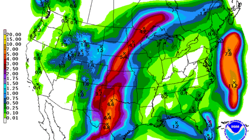
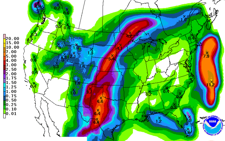
Precipitation should be concentrated in western and central Nebraska Saturday, gradually moving into central and eastern Nebraska on Sunday. Light showers are expected for western Nebraska on Sunday, with heavy moisture likely for central Nebraska. Eastern Nebraska will likely experience light to moderate rainfall on Sunday continuing through Monday. Light showers would then be possible during the first half of Tuesday in eastern Nebraska. Weather models have gradually increased precipitation forecasts for this weekend, from 1-2 inches predicted last Friday to current forecasts of 2-4 inches. A peak output from this storm system is forecast at 5.5 inches across central Nebraska.
If this moisture output from the weather models verifies, short-term dryness issues will be resolved, helping wheat stands become established. The good news is that these same models indicate that an extended period of dryness is likely between September 25 and October 3. A quick moving wave is currently shown to impact the eastern one-third of Nebraska October 3-5, and then dry conditions are indicated for the entire state through the end of the model period (October 7). Based on the position of high-pressure systems indicated by the model for October 7, we will likely experience an additional week of dry weather before any major system could impact the state.
| Location | GDD From April 30 Emergence* | GDD From May 15 Emergence* | GDD From May 31 Emergence* | Hybrid GDD/Days to Maturity | Hard Freeze Risk for April 30 Emergence** | Hard Freeze Risk for May 15 Emergence** | Hard Freeze Risk for May 31 Emergence** | Replant GDD/Days to Maturity | Hard Freeze Risk for May 15 Replant** | Hard Freeze Risk for May 31 Replant** |
|---|---|---|---|---|---|---|---|---|---|---|
| Alliance | 2315 | 2183 | 2064 | 2280/95 | 0 | 20% | 63% | 2159/90 | 0% | 27% |
| Scottsbluff | 2416 | 2266 | 2137 | 2280/95 | 0 | 6% | 40% | 2159/90 | 0% | 10% |
| Sidney | 2414 | 2263 | 2125 | 2352/98 | 0 | 16% | 68% | 2231/93 | 2% | 30% |
| Imperial | 2535 | 2367 | 2210 | 2594/108 | 0 | 28% | 70% | 2473/103 | 5% | 43% |
| McCook | 2713 | 2530 | 2353 | 2715/113 | 0 | 11% | 54% | 2594/108 | 0% | 25% |
| Alda | 2655 | 2312 | 2312 | 2715/113 | 0 | 26% | 69% | 2594/108 | 5% | 40% |
| Guide Rock | 2742 | 2367 | 2367 | 2715/113 | 0 | 10% | 60% | 2594/108 | 0% | 26% |
| York | 2730 | 2542 | 2347 | 2715/113 | 0 | 4% | 36% | 2594/108 | 0% | 18% |
| Dixon | 2565 | 2384 | 2229 | 2594/108 | 0 | 29% | 74% | 2473/103 | 7% | 50% |
| Mead | 2729 | 2546 | 2355 | 2715/113 | 0 | 7% | 57% | 2594/108 | 0% | 22% |
| Beatrice | 2794 | 2600 | 2406 | 2715/113 | 0 | 3% | 28% | 2594/108 | 0 | 26% |
| *Growing Degree Day accumulations since emergence date using upper limit of 86°F and lower limit of 50°F **Hard freeze risk is the first fall minimum temperature of 28°F or lower. Percent risk is determined using the 1987-2016 period and based on normal temperatures through corn black layer. | ||||||||||
