Soil conditions, the weather forecast, freeze risk and projected days needed for planting are all part of the decision as to when to get into the field. These factors can be highly variable from year to year and it can be challenging to know when we will reach, and maintain, soil temperatures conducive to proper crop germination.


April 9 Freeze Forecast
The National Weather Service has issued a freeze warning for eastern Nebraska with lows expected to range from 24° to 28°F for several hours early morning April 9.

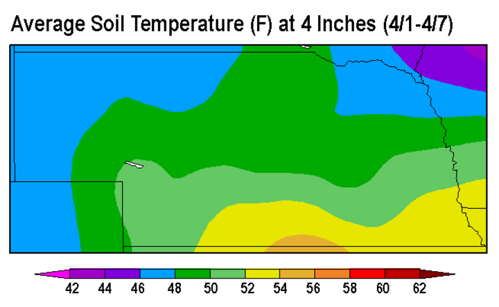
Current seven-day average soil temperatures (Figure 1) at 4 inches under bare soil are near normal for most of the state. Portions of southern and southeast Nebraska are in the mid 50s and northeast and northwest Nebraska are in the mid to upper 40s. While the soil temperatures may be close to proper germination for corn, the field to field variability and risk of frost may limit the success of crops planted too early.
It is not that uncommon for snowstorms to move through Nebraska in May and cold temperatures to remain for some time. Even though most of Nebraska may have reached adequate soil temperatures for planting corn, it is imperative that you analyze the risk and use current weather trends and climatology to make an informed decision. There may be some benefit to early planting to capture a longer growing season; however, the risk of freeze damage may outweigh the award. You’ll also want to consider crop insurance initial planting dates (corn, April 10 for southern and eastern Nebraska and April 15 for western and north central Nebraska; soybean, April 25).
Nebraska Average Last Frost Date
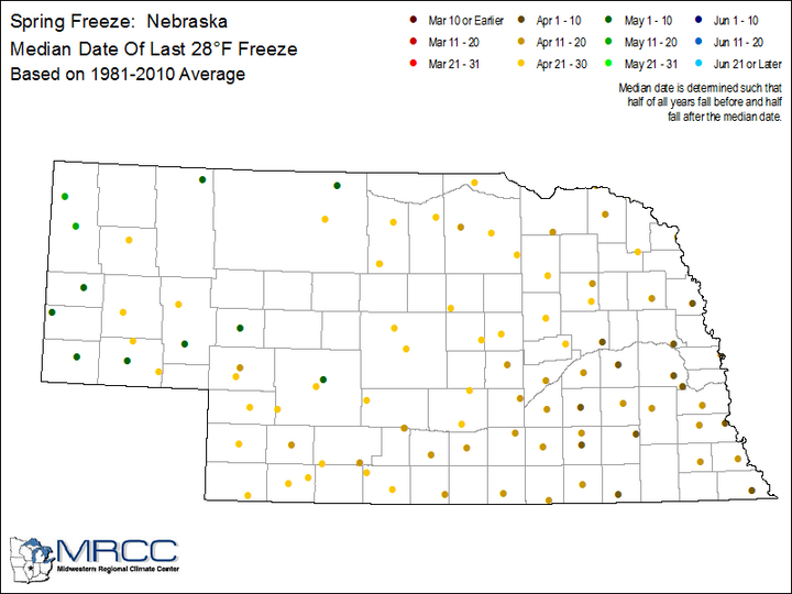
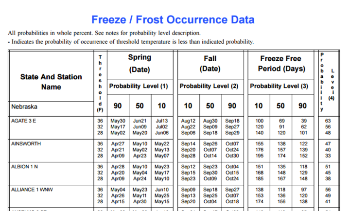
The average last frost date is one way to analyze the risk of frost damage to your crops. Figure 2 shows the median last 28⁰F freeze for Nebraska from 1981-2010 average. The median date for southeast Nebraska is the first week or two of April, moving later as you go north and west. During this period the latest date for a 28°F freeze was the second week of May for most of Nebraska; however, freezes did occur in June for locations in the Panhandle. More comprehensive Nebraska freeze data (sample data, Figure 3) for multiple locations is available from the National Climatic Data Center.
Freezing temperatures (32°F or lower) during May have been fairly frequent the last five years.
- North Platte has recorded freezing temperatures five out of the last five Mays
- Scottsbluff has four of the last five Mays,
- Lincoln three of the last five Mays, and
- Grand Island two of the last five Mays.
Measurements were taken at local airports; nearby urban or rural locations may have recorded lower temperatures. Here are the range of last frost/freeze dates for these four locations for the past five years, along with their measured low temperature:
- Scottsbluff: 5/5/11 – 32; 4/18/12 – 31; 5/5/13 – 26; 5/15/14 – 31; 5/11/15 – 29
- North Platte: 5/16/11 – 30; 5/14/12 – 32; 5/5/13 – 22; 5/17/14 – 31; 5/21/15 – 30
- Grand Island: 4/20/11 – 29; 4/11/12 – 30; 5/5/13 – 30; 5/17/14 – 32, 4/22/15 - 27
- Lincoln: 5/3/11 – 32; 4/23/12 – 31; 5/12/13 – 313; 5/16/14 – 30; 4/22/15 - 26
Certainly elevation plays a key role in freeze risk during May, so we should not be surprised by how often freezing temperatures occur in May at higher elevations. Also, it should be noted that freezes have occurred in May in three of the last five years across eastern Nebraska. Early April corn planting increases the risk that frost/freeze events can catch corn at the 6-leaf stage and beyond, when the growing point is no longer below the soil surface.
April Forecast
The April Outlook from the Climate Prediction Center gives Nebraska increased probabilities for having above normal temperatures and an equal chance of above or below normal precipitation. Over the last couple months, most of Nebraska has been relatively dry and warm and some abnormally dry conditions have developed in along the southern tier of the state. Because this dryness ranks in the lowest 10 percent of historic data, this week the Drought Monitor rated this area as abnormally dry.
Most of the state has above normal moisture for the recharge period dating back to October 1, so the abnormally dry conditions introduced by the Drought Monitor authors this week just reflects short-term dryness leading to concern that surface drying may play a role in early season germination rates if widespread rainfall fails to materialize during April. The April Outlook does not provide a lot of confidence that these conditions will reverse this month and should be monitored through the start of the growing season.
