2025 Growing Season Outlook
For a 2025 growing season weather outlook, join Nebraska Extension Meteorologist Eric Hunt and Conduit Ag's Eric Snodgrass for a special joint webinar at 9 a.m. CT on Friday, Feb. 14. Registration is free.
Windy Saturday
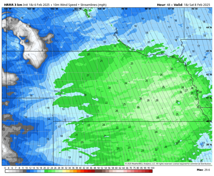
The next few days will feature nicer conditions with sunshine and temperatures running a bit above seasonal normals for most of the state. The southern Panhandle will be the exception where temperatures may climb into the lower 60s Friday afternoon, Feb. 7. A weaker storm and frontal passage will move through the area on Saturday morning, bringing a chance of a light wintry mix to the northern half of the state. Winds will pick up from the northwest on Saturday, Feb. 8 behind the front, likely gusting over 40 mph for much of the state between 10 a.m. and 3 p.m. Temperatures will be seasonal in the 30s on both Saturday and Sunday but the wind will make it feel rather cold.
The Polar Express
A highly amplified pattern coupled with some polar vortex stretching will bring much colder temperatures to the northwestern and north-central sections of the U.S. next week. Arctic air should start invading northwest Nebraska on Sunday night, Feb. 9 and will move southeast during the day on Monday, Feb. 10. In addition, multiple shortwaves moving into the region will help produce a few rounds of light snow starting Monday evening. First round of snow should give everyone a shot at an inch and should be done by Tuesday afternoon, Feb. 11. The next round is likely to concentrate accumulating snow along and south of I-80 with an additional 1-2 inches later Tuesday night into Wednesday, Feb. 12.
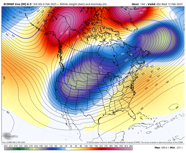
Snowfall rates on Tuesday won't be high. But the wind will be gusty from the north, which will make the visibility lower, and air temperatures will likely be holding in the upper single digits to mid-teens. Thus, travel should be done with great caution. Temperatures will remain very cold on Wednesday, with highs possibly not breaking the double digits in the northern fringe of the state. Subzero low temperatures are likely along and north of I-80 the middle of next week and probable in the southern third of the state.
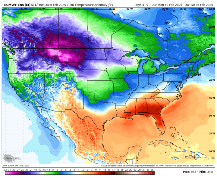
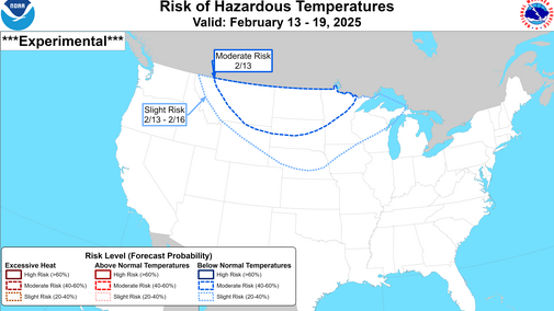
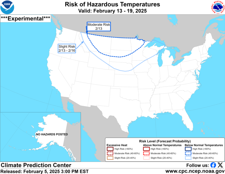
A brief thaw will be possible later next week with highs possibly getting above freezing in western and southern sections of the state next Friday. But another round of polar vortex stretching is looking likely next weekend, which will bring down more Arctic air. The CPC has much of the state in the slight risk for hazardous cold next weekend. In addition, there is signal in the models for another storm system to enter the central U.S. next weekend, which could bring additional chances for snow. A few model runs over the last few days suggest it will be possible for significant snow to fall over eastern Nebraska next weekend. Too early to make a definitive statement on a winter storm but something to watch out for.
Southeast Nebraska gets moisture. Very little anywhere else
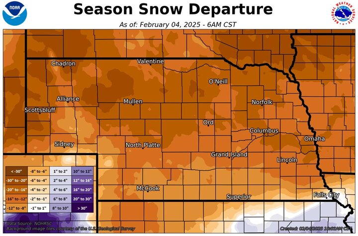
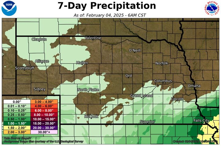
A storm system brought significant rainfall to the far southeast section of Nebraska Jan. 30 with 0.10-inch of rain falling across a broader section of southern Nebraska. The remainder of the state had negligible or no precipitation from that system.
Official statewide numbers for January 2025 aren't in yet. But most of the state was much drier than average, with Lincoln and Omaha having their 10th and 5th driest January's on record. Some areas northwest of Norfolk did not have any measurable precipitation.
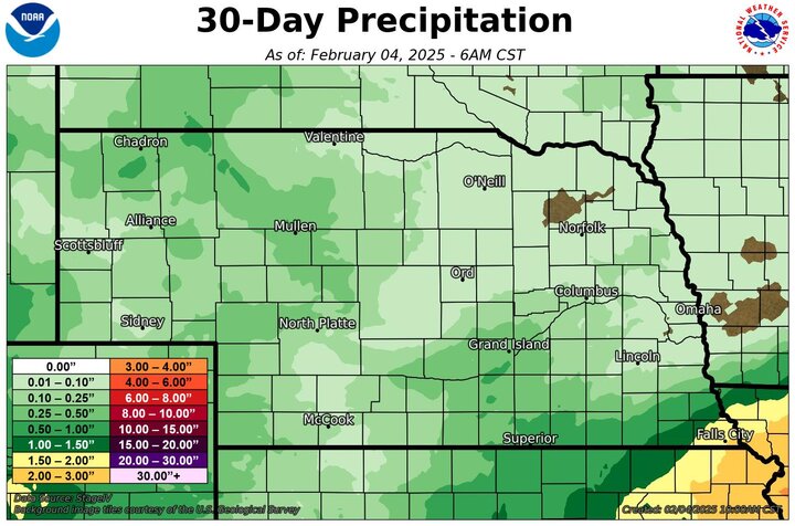
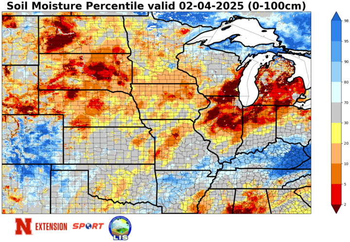
Given that this is the driest time of year, the deficits were not large in an absolute sense. But soil moisture has declined some over the past month with the lack of precipitation. Most of the state is short on soil moisture and the gains made in November are slowly being chipped away. Driest soils relative to normal are found in the north-central and Panhandle regions of the state but most places now are at least in the 30th percentile or lower for moisture.
Drought not getting worse. But not getting better either.
The almost complete lack of snow this year for the state (with a few exceptions) has not necessarily made the drought worse in a technical sense. But it has meant that we are losing soil moisture, albeit in not huge quantities, instead of preserving moisture that we do have. The lack of snow cover also helps temperatures moderate much more quickly this time of year when we are under warmer air masses. Hence, the number of days where we have had high temperatures in the 50s to low 60s over the last few weeks after the last cold snap.
If there had been snow on the ground in January, our temperatures would have been considerably colder. As it was, Falls City had a colder January than Omaha because of the presence of snow in the area around Falls City compared to the lack of it further north. The lack of snow cover means mid-winter temperatures get warmer than historical norms rather easily (absent strong cold advection) and those warmer temperatures and sun can lead to losses of moisture from the top part of the soil.