March 16, 2012
Winter Temperatures Average 8 Degrees Above Normal
See related story, Regional Climate and Soil Moisture Updates
It has certainly been an interesting fall and winter across most of the continental United States. As La Nina conditions developed for a second consecutive fall across the Equatorial Pacific, dry conditions were firmly established across the northern Plains. This promoted excellent harvest conditions, but resulted in sub-par soil moisture recharge before frost set in the ground.
|

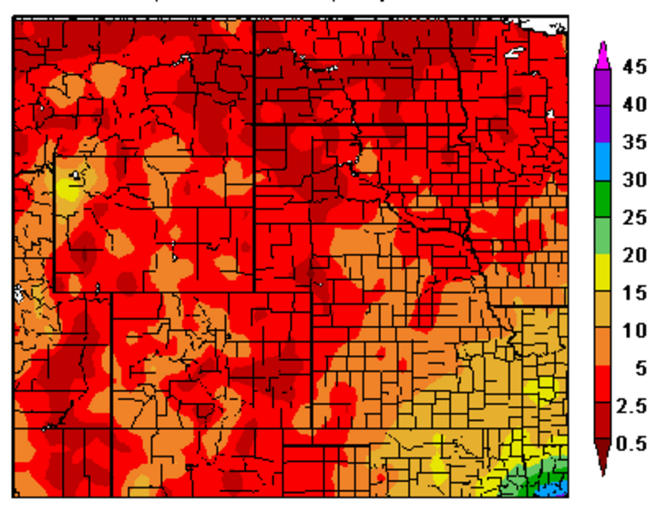
Precipitation (inches) in the western High Plains from Oct. 1, 2011 to March 11, 2012. (Source: High Plains Regional Climate Center)

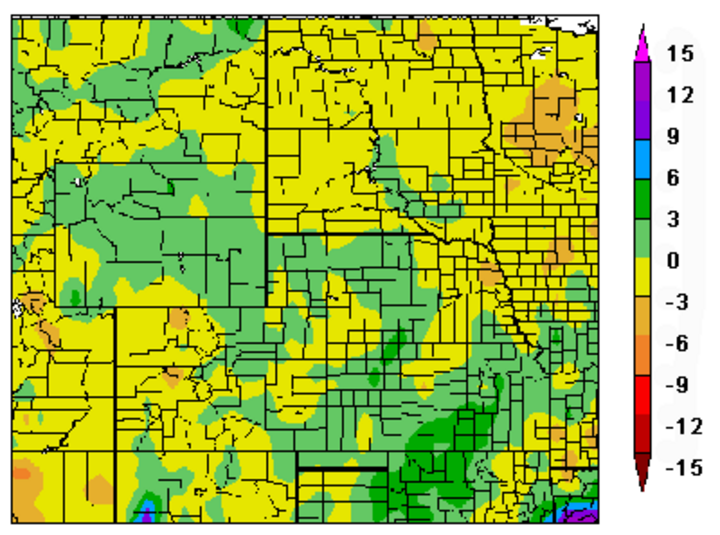
Departure from normal precipitation (inches) in the western High Plains from Oct. 1, 2011 to March 11, 2012. (Source: High Plains Regional Climate Center) See additional Regional Reports and Maps. |
Last fall’s climate pattern was typical of a La Nina, but it was unusual in that the dryness continued through winter across the northern Plains. During a La Nina, this region usually experiences normal to above normal moisture and below normal temperatures. This winter the dominant jet stream split, with the polar jet remaining in the northern region and upper air lows moving through the southern Plains, bringing abundant moisture to the southern third of the U.S. with a major system moving through every 7-10 days.
With the split flow pattern, snowfall has been well below normal across the northern Plains and temperatures averaged at least 8 degrees (Fahrenheit) above normal for much of the northern Corn Belt this past winter. The only remaining frost lies in areas adjacent to the Canadian border and will likely be a non-issue within the next week to 10 days. With the lack of snow cover, there is a below average flood risk within the Platte and Missouri watersheds this spring.
Mountain snowpack is below normal across most of the southern Sierra and Rocky mountain ranges. Across the northern Rockies, snowpack conditions are running slightly below normal to slightly above normal, with early snow melt predicted. There is a distinct possibility that the snowpack could be completely gone before mid-June. This scenario developed in 2000, 2002, and 2004 and helped reinforce drought development across the central and northern High Plains during the growing season.
The above normal temperatures are promoting rapid wheat growth across the southern and central Plains. Wheat growth is running about two weeks ahead of the 2007 cropping season and much of the crop has reached the jointing stage or is beyond. With high temperatures projected to be 10-20°F above normal for the next two weeks, the crop will be vulnerable to a hard freeze (
La Nina Moving Directly to an El Nino
It is readily apparent that the Equatorial Pacific La Nina event is rapidly decaying and an El Nino event is in its early formation. There have been 10 back to back La Nina events since 1900. Four of them immediately transitioned to El Nino conditions, while the remaining 6 returned for a third consecutive year. Since 1950, there have been 3 La Nina multi-year events that shifted into an El Nino; 1951, 1957, and 1972.
It is possible that a combination of La Nina and El Nino impacts will be experienced for the next couple of months before El Nino conditions dominate the summer growing season. Therefore, the split flow pattern will likely continue with an occasional polar jet trough rolling through the northern Plains. If one of these troughs digs far enough south, freezing conditions could be pulled into the southern and central Plains jeopardizing wheat and alfalfa production.
What Does this Indicate for the Crop Season?
Nebraska Wheat UpdateExtension educator Karen DeBoer in Cheyenne County reported this week that wheat was greening up with the warmer temperatures, but that several windy days had dried the surface soil. "More moisture will be need as the wheat continues to grow," she wrote. "We are just barely getting a little more green in the wheat and could really use some rain. It's getting critical," wrote Doug Anderson, extension educator in Keith, Arthur, and Perkins counties. Greg Kruger, extension cropping systems specialist at the West Central REC in North Platte, echoed his comments. "We could really use some moisture in the top few inches of soil. The soil temperature here was 50°F at 2 inches on Tuesday."
This week's U.S. Drought Monitor shows northeast Nebraska, southwest Nebraska, and the southern Panhandle as "abnormally dry." |
The open winter has allowed producers across much of the northern and western Corn Belt to complete typical spring activities more than a month ahead of schedule. If warm, dry conditions continue, producers could begin planting corn two or more weeks ahead of normal. If corn emerges by mid-April, a freeze in early to mid-May could cause significant damage.
Weather models point toward the split flow pattern continuing into the foreseeable future. This should promote moisture for the southern Plains wheat, but continued dry conditions across the northern Plains, below normal snowfall across the southern Rockies. and an early melt of the current snowpack.
The Climate Prediction Center has put together a risk analysis of precipitation and temperature trends during El Nino and La Nina events. From March to May, La Nina conditions support drier than normal conditions across the western Corn Belt, while El Nino supports dryness across the northern Corn Belt. If we are in an El Nino pattern by June, we’re likely to see drier than normal conditions in the central and eastern Corn Belt. Moisture is generally normal to above normal across the western Corn Belt, with the best moisture chances in late summer.
Because snowpack levels in the central and southern Rockies are generally below normal, above normal spring temperatures would promote early melt. If the snowpack disappears before mid-June, the upper atmosphere could warm rapidly, shutting off thunderstorm development along the front range of the Rocky Mountains. These thunderstorms provide moisture that the western Corn Belt needs to bridge the gap until monsoon moisture lifts from the southwestern U.S. into the region by early August.
Is it possible that the United States can produce record corn yields in 2012? Yes, but it will take near perfect weather and a significant change in the jet stream pattern to focus moisture across the northern and western Corn Belt. Otherwise, drought conditions will rapidly materialize in the northern Plains. In Nebraska this would affect northeast counties, which have had below normal moisture since August 2011.
Coupled with an El Nino that favors drier than normal summer conditions from Iowa east through Ohio, we will be hard pressed to hit the national trend line for corn yields this year. The additional acres projected to be planted into corn could easily replace some lost production, but only if drought conditions do not intensify and expand into the central and eastern Corn Belt as the summer progresses.
Al Dutcher
Extension State Climatologist
