Bomb Cyclone
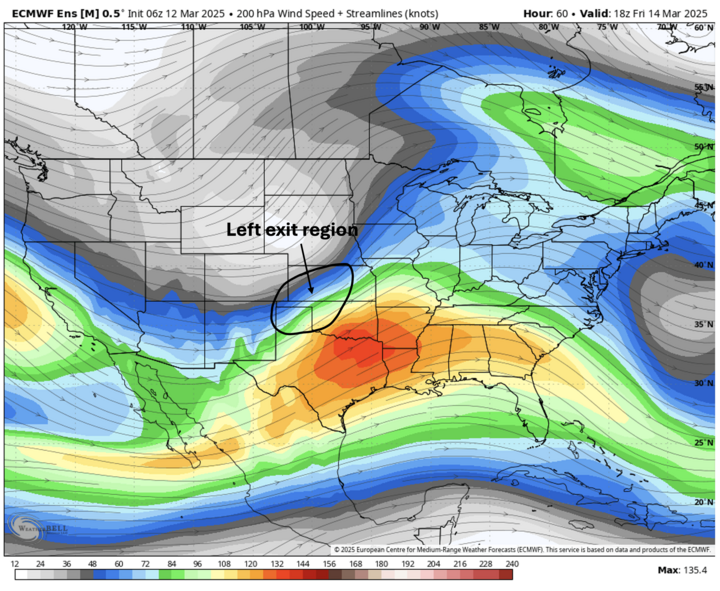
A storm moving from the Front Range into the Central will strengthen rapidly due to optimal amounts of upper air divergence that comes with the left exit region of a powerful jet stream. Impacts from the storm will be mostly in the form of higher wind speeds but at levels below last Tuesday and Wednesday. Precipitation will be likely for everyone Friday, March 14, but only northeastern Nebraska is likely to receive a half inch or more. Most areas of the state are likely going to be under a quarter inch unless showers and thunderstorms are more numerous and intense than is currently forecast.
The storm will begin to affect the state starting Friday morning as showers begin to develop across the Panhandle. Rain likely will change to snow later in the day across western Nebraska and winds will be gusty from the northwest. Further east, temperatures will be warmer, likely getting into the 70s in eastern Nebraska and into the 60s across the central section of the state.
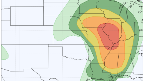
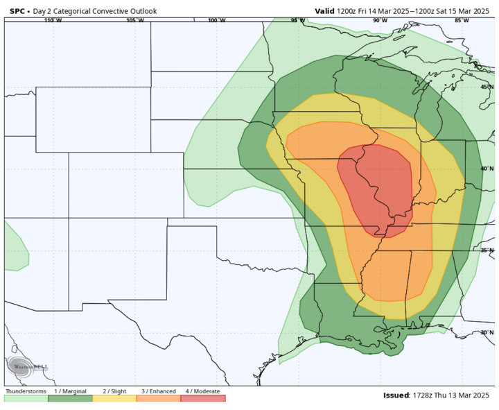
The threat for severe weather Friday afternoon is increasing in eastern Nebraska. The SPC now has most of the eastern sixth of the state in the slight risk category, with the marginal risk extending out to O'Neill and Holdrege. The high-resolution models are getting a bit more bullish on thunderstorms developing in the eastern third of the state after 1 p.m. Supercell development with hail would be possible east of Highway 77. The good news is the threat will be relatively short-lived, but the bad news is that threat may still be there in the Omaha and Lincoln metro areas during rush hour. Best chance of seeing tornadoes tomorrow will be in eastern Iowa and Illinois. Areas to our south have elevated to critical levels of fire danger.
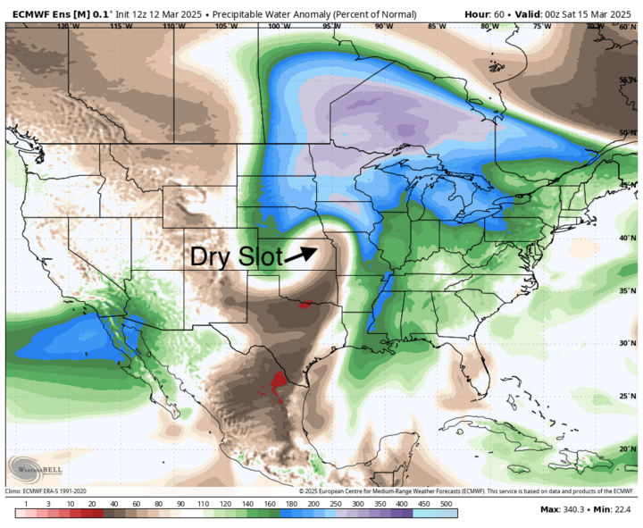
By Friday night, the surface low will be to our east in Iowa and a deformation band of precipitation should set up in the eastern third of the state (excluding the Kansas border counties). This will be more rain than snow but residents in Knox and Holt counties may get a period of heavy snow. Wind speeds will be in the 20-30 mph statewide on Friday night and on Saturday with gusts possibly approaching 45-50 mph in north-central and northeastern Nebraska. Not as bad as last week but enough to cause visibility issues in areas where snow does fall. The speed of the storm and the large dry slot near the surface low will prevent anyone from picking up a two-inch soaking.
Nevertheless, most areas should pick up some moisture on Friday and early Saturday, with amounts over a half inch most likely in northeast Nebraska where the deformation precipitation is likely to be heaviest and of longest duration. Most of western Nebraska should pick up some moisture, including some in the form of snow, but amounts are likely to be under a quarter inch.
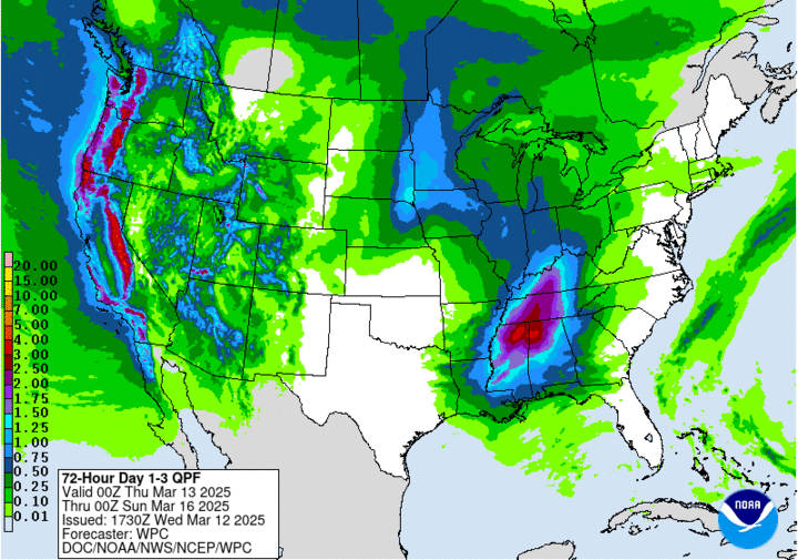
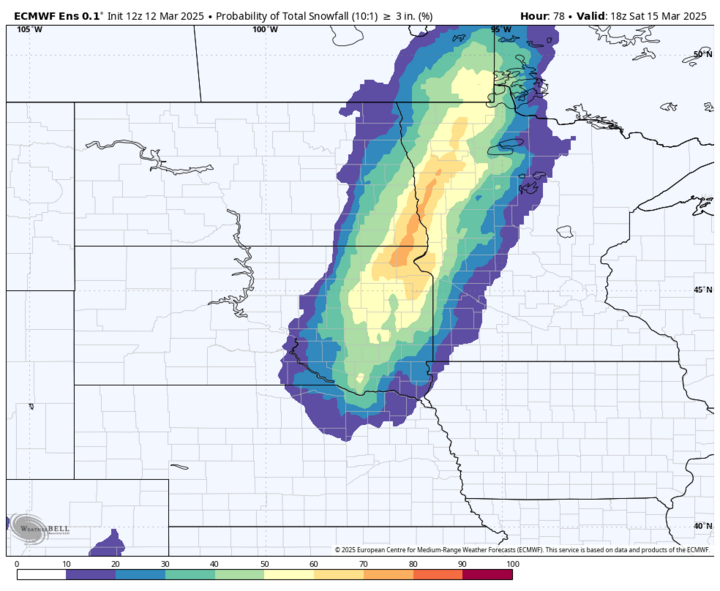
The central and northeastern sections will have a chance to pick up some showers on Friday morning with more rain likely to fall on Friday night on the back side of the storm. Areas from Ord to O'Neill likely to get a half inch of rain or more with an inch of moisture possible between Wayne and Ponca. Snow will be likely along and north of Highway 20. Best chance of getting three inches of snow would be around Niobrara.
The southeastern quadrant of the state is a bit trickier. Some spots could pick up a quarter to half inch early Friday afternoon from thunderstorms and precipitation on Friday night could extend as far south as Lincoln and Nebraska City. But the dry slot is likely to preclude most of southeast Nebraska from getting precipitation on Friday evening, and the precipitation on the back side of the low — likely won't make it south of Highway 2. So there is a possibility places from Fairbury to Falls City could get nothing but wind from this storm. Fire danger may also be elevated near the Kansas border in southeast Nebraska on Friday evening once the dry slot moves in.
March Rollercoaster
Warm and Sunny
Sunday will feature warmer temperatures and lighter winds than Saturday and things look very nice for St. Patrick's Day. A ridge will be sitting over us during the day and this will bring ample sunshine and warm temperatures. Highs likely to be in the 70s statewide with temperatures at or slightly above 80°F possible across south central and southeast Nebraska.
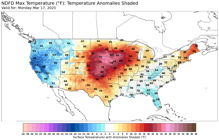
Winds will be a bit elevated on Monday in the northwestern quadrant of the state Nebraska, so there will be some fire danger risk between Valentine and Chadron. Elsewhere winds will be lighter. Perfect day for playing hooky from work and golfing or enjoying a green beverage on a patio!
Snow?
Mother Nature has a sense of humor and wants to keep us on our toes so the warm weather isn't going to last. A front will be moving through the state on Tuesday, bringing sharply colder temperatures compared to Monday for the western and northern halves of the state. The southeast quadrant should enjoy another warm day in the 70s but temperatures may drop quickly in the afternoon if the front is a little speedier than currently forecast.
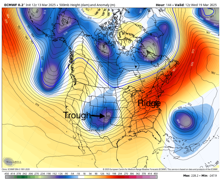
As we move into Tuesday night, another trough will be moving into the Central Plains and this will help generate the rising motion needed to produce precipitation across the state. There is still some uncertainty as to the exact path and strength of the storm system. But there is a good chance of moisture statewide starting Tuesday night in western Nebraska and during the day Wednesday in the eastern half of the state. Current indications are that there will be sufficient cold air and dynamics for a rain to snow scenario for basically the entire state, with 1-3 inches of snow likely for the whole state and areas from Hastings to Omaha having the best chance at more than 4 inches.
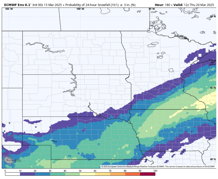
The ECMWF AI model has been more aggressive on moisture return and shows a better chance of 0.5-inch to 1.0 inch of total moisture across eastern Nebraska, with some falling as rain initially followed by 4-6 inches of snow. Wind speeds are also likely to be in the 15-25 mph range from the north and northwest, so visibility may be an issue, especially on east-west roads if snow does indeed come to fruition. It is quite possible that roadway accumulation will be minimal in the eastern half of the state due to falling on warmer ground and during the daytime hours. Nevertheless, it will be a raw and cold day on Wednesday with temperatures likely not getting out of the 30s in eastern Nebraska and only getting to 40-45°F in central and western Nebraska.
Mild weather returns. More precipitation next weekend?
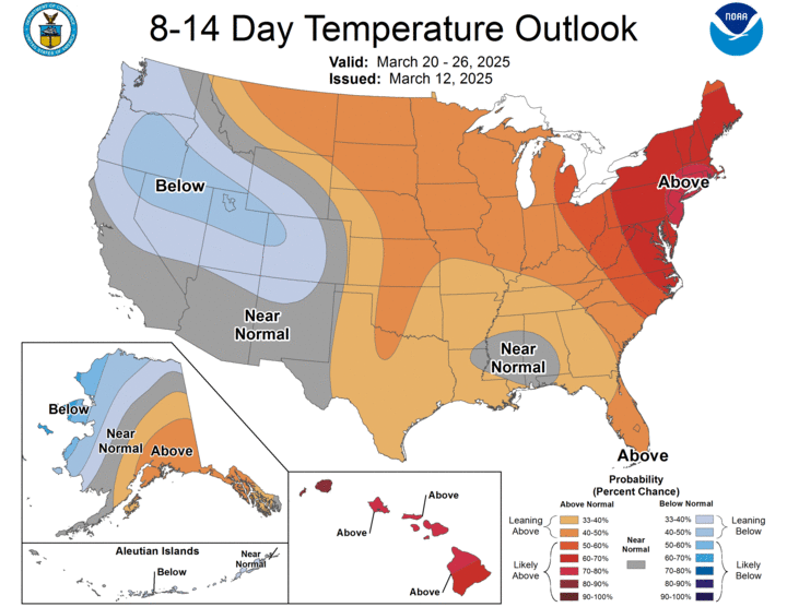
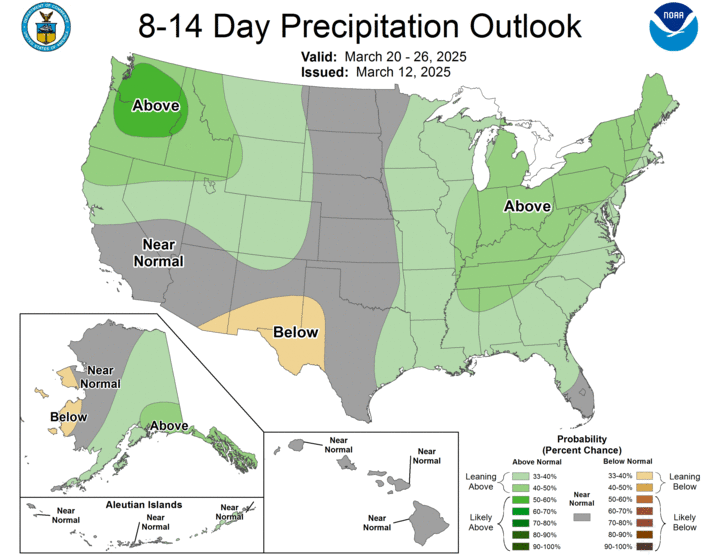
Temperatures should moderate later next week and the CPC favors warmer than average in the period from March 20-26. But we may be done with the exceptionally warm temperatures for a little while after Monday. Additional precipitation is also possible next weekend as another storm system moves into the Central Plains. That would most likely be all rain and it is possible that the northern third of the state misses out on precipitation.
Drought Update
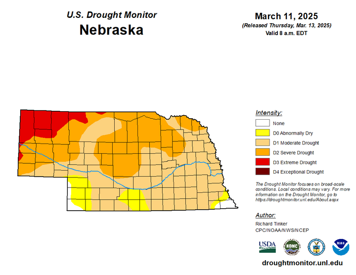
Precipitation last week did improve soil moisture percentiles a bit across northeast Nebraska and portions of the Sand Hills. But most of the state is still under the 30th percentile for soil moisture in the top 1-meter of soil. Thus, any and all moisture that falls over the next few weeks will certainly be welcome as soil moisture is still quite short across much of the state and the broader region in general.

The latest Drought Monitor shows some improvement in the Sandhills from severe (D2) to moderate (D1) drought from western Rock and Cherry County down into McPherson and Logan counties. There was a small area of degradation from abnormal dryness (D0) to moderate drought (D1) in Deuel and Keith counties. Ninety-one percent of the state is in some form of drought, up slightly from last week. It is possible enough precipitation may fall over the next 10 days to bring improvement in drought status in parts of eastern Nebraska.