Warmer Temperatures
The upper-level low that has been responsible for the recent cooler and gloomy weather will be moving out of the upper Midwest by Friday and that will lead to warmer temperatures and more sunshine. Highs between the upper 70s and low 80s will be the rule and winds should be lighter. Get out and enjoy it!
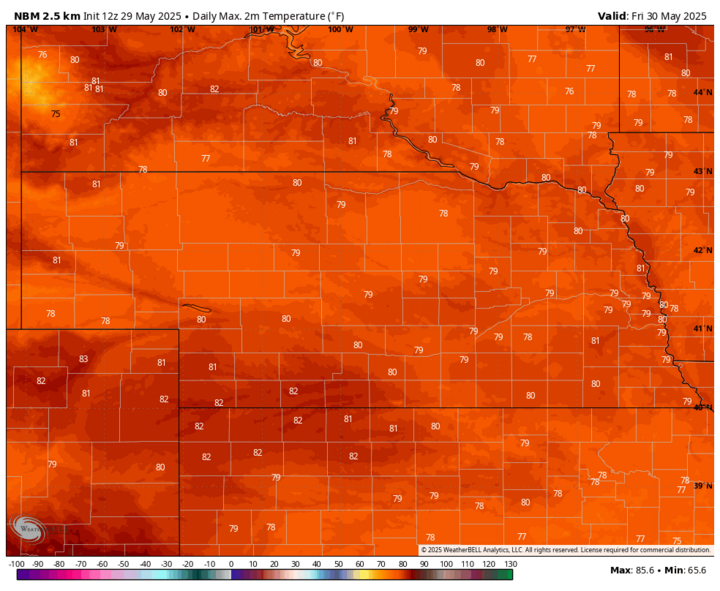
Saturday will be even warmer still in the eastern half of the state, with highs likely getting into the mid- to upper 80s. It does appear another shortwave will be entering the eastern half the state during the day Saturday, so don't be surprised if there are scattered showers and thunderstorms east of Highway 281 in the afternoon hours. But amounts would not be that significant. Temperatures will remain warm statewide on Sunday and may get to 90°F in southwestern and eastern Nebraska on Monday. It will also be on the breezy side in western Nebraska on Sunday and statewide on Monday. The warm weather will be good news for crops that have been a little short on heat unit accumulation with the cooler temperatures that have prevailed of late.
Rain and Storms
By late Monday, the western trough will start having an impact on our weather. The current prognosis is that a surface low will be developing along the Front Range and moving into western Nebraska by late Monday. That will open up good chances for showers and thunderstorms to develop in the Panhandle (severe possible) by later Monday and move to the east and northeast into the Sandhills and Dakotas. Additional storms are likely to develop later Monday night in central sections of the state and move into eastern Nebraska on Tuesday morning into the early afternoon hours.
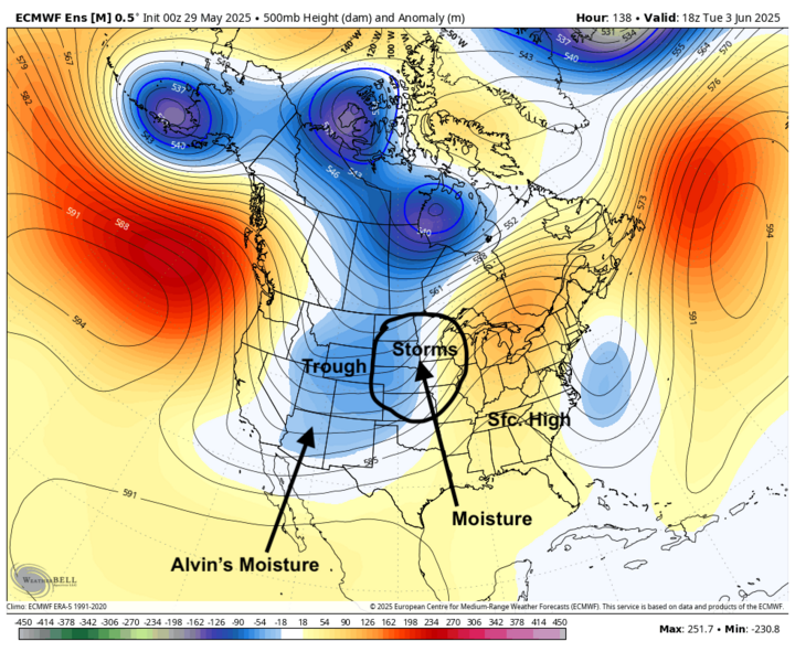
This may not be a great rain maker for the southwestern part of the state, but this should be a good chance for most other areas to get over half an inch. Working in our favor to get better rains are a surface high in the southeast, which will help draw up Gulf moisture and the potential influence of tropical moisture from tropical storm Alvin being drawn up from the southwest. The WPC is most bullish on heavier precipitation falling in the northwest and southeast corners of the state.
Additional Chances Thursday-Friday Morning?
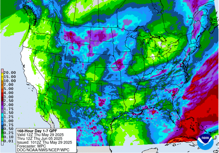
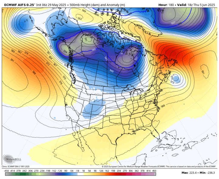
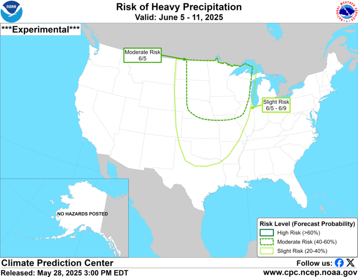
A cold front should clear the state by Tuesday night, bringing drier and somewhat cooler temperatures for Wednesday. The bigger question is what happens as we get into Thursday. If the trough that is over the southwestern U.S. can get "picked up" by the upstream trough in Canada, as suggested by the ECMWF's AI model, then the chance of showers and storms in the eastern two-thirds of the state will increase by Thursday afternoon, with the potential for significant precipitation in eastern Nebraska Thursday night into Friday. If it remains cutoff from the main flow and meanders east, we likely will be dry for the remainder of the week. The CPC does have the eastern half of the state in the moderate risk for heavy precipitation on June 5. So that potential for additional beneficial moisture is there later next week.
Extended Forecast
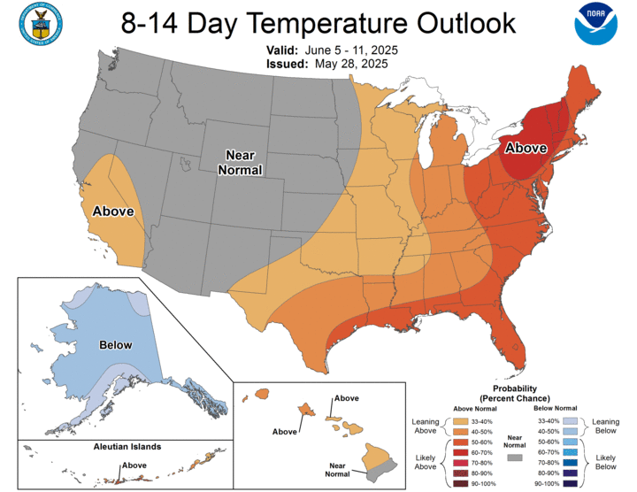
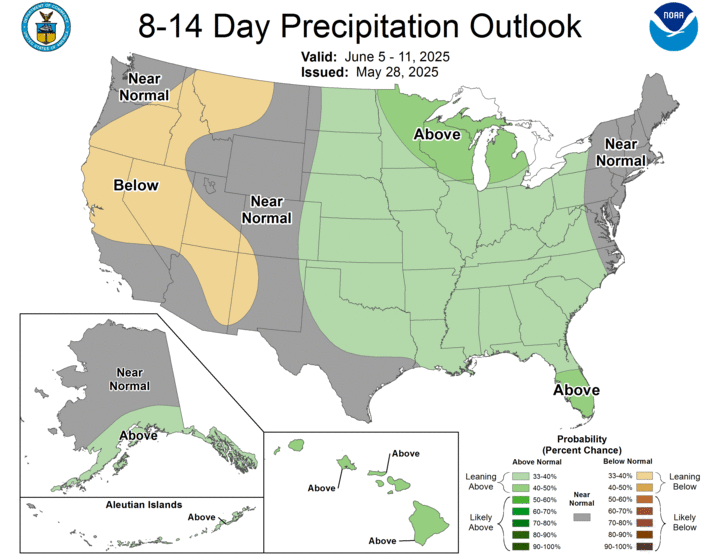
Warmer temperatures are likely to return by the end of next week but will be short-lived as another cold front likely will move through the region by June 8. That would bring another shot of moisture and temperatures back to seasonal or below seasonal levels for the beginning of the week after next. The CPC isn't showing a strong signal on temperatures in the 8-14 day outlook for the state or Northern Plains. It's possible that temperatures may be a little bit cooler in our region than is currently depicted here. CPC also indicates a slightly better chance for above average moisture during the eight- to 14-day period.
Kicking Drought Can Down the Road
The good news is that the first part of June may bring sufficient precipitation to much of the state and may be enough to provide some soil moisture recharge and drought relief. It is possible that we will have an active enough pattern throughout the summer to give us periodic, timely rains and avoid drought impacts to our main summer crops. The wetter soils to our south and southeast may benefit us in the form of helping "preserve" the moisture return from the Gulf through June, which means that we may be able to generate more precipitation in areas that still have seasonal deficits to offset.
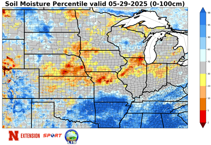
But there is definitely still concern for our region of the country to get cut off from the main storm track for extended stretches later in the summer. Going into astronomical summer with adequate moisture is always a plus, but while that moisture could help get us to early July, it won't get us through two months of hot and dry if things align for an upper-level ridge to form in the central portion of the continent. That is not a guarantee, but the risk is still there. For now, we may be avoiding the worst-case scenario, but all we have for sure done is to kick the drought can down the road.
