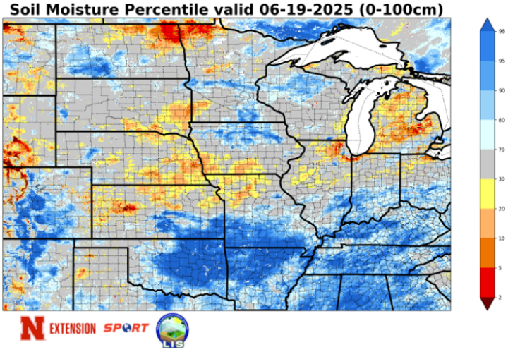
Soil Moisture Decline
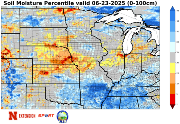
This weekend featured a combination of hot temperatures and persistent strong winds, especially for central and eastern sections of the state. This combination led to a rapid decline in soil moisture according to NASA's SPORTLIS. Check out the difference in soil moisture percentiles across south-central and eastern Nebraska between Figures 1 (near-current) and Figure 2 (last Thursday).
Potential ET
The reason for the soil moisture decline was that the combination of wind and heat maximized potential ET. There are various ways to calculate potential (or reference) ET but for purposes of this article, the standard Penman-Monteith method was used and assumed alfalfa for ground cover (this is common). Based on those assumptions, almost every Mesonet site had at least 1.5 inches of potential ET over the three-day period ending Sunday night, June 22. Some sites were over 2 inches and the Indianola 8 SW site near McCook had over 2.5 inches.
This does not mean that the actual ET was that high over a corn field, as most corn around the state is not far enough along for the crop coefficient to be 1.0 or higher just yet. Nevertheless, even a more conservative estimate of 0.7 would yield 1 inch or more of ET for all but the Panhandle sites that were considerably cooler on Sunday, thanks to getting the front first. In other words, there's a reasonably good chance most fields lost an inch-plus of moisture this weekend. We will need the rain that is coming in the coming days to replenish what we lost, or this weekend may well have been the beginning of a flash drought for the Central Plains and Western Corn Belt.
The table below shows the accumulated potential ET by site.
| Mesonet Station: | Total Pot ET |
|---|---|
| Alda 5NW | 1.863 |
| Alliance 6NW | 1.389 |
| Arthur 8S | 1.558 |
| Axtell 5NE | 1.867 |
| Big Springs 6SE | 1.838 |
| Big Springs 8NE | 1.667 |
| Broadwater 7N | 1.26 |
| Bushnell 12SE | 1.521 |
| Central City 3W | 1.694 |
| Concord 2E | 1.877 |
| Cook 4SW | 1.71 |
| Decatur 7S | 1.814 |
| Dickens 1NE | 1.774 |
| Eagle 3NW Beta | 1.707 |
| Emmet 2E | 1.397 |
| Enders 10SW | 1.973 |
| Firth 3N | 1.71 |
| Fordyce 4N | 1.878 |
| Gothenburg 2NW | 2.063 |
| Guide Rock 3E | 1.607 |
| Harrisburg 1N | 1.64 |
| Harvard 4SW | 1.611 |
| Hayes Center 3N | 1.889 |
| Holdrege 5N | 1.925 |
| Indianola 8SW | 2.51 |
| Kearney 3E | 2.061 |
| Keystone 4W | 1.808 |
| Leigh 1W | 1.759 |
| Lexington 4S | 1.853 |
| Lincoln 1500 N 45th | 1.647 |
| Long Pine 20S | 1.566 |
| Memphis 4N | 1.576 |
| Memphis 5N | 1.598 |
| Merna 2SW | 1.451 |
| Naper 12SW | 1.753 |
| Nebraska City 3W | 1.742 |
| North Platte 3SW Beta | 1.503 |
| Oakland 4W | 1.773 |
| Ord 2N | 1.801 |
| Oshkosh 6N | 1.607 |
| Overton 6SE | 1.867 |
| Pierce 2SW | 1.722 |
| Plattsmouth 2SE | 1.538 |
| Rulo 5SW | 1.502 |
| Scottsbluff 2NW | 1.34 |
| Scottsbluff 6NW | 1.529 |
| Shelton 2SW | 1.831 |
| Sidney 2NW | 1.522 |
| Smithfield 2E | 1.827 |
| Valparaiso 6NW | 1.515 |
| Walton 5NW | 1.682 |
| Whitman 5NE | 1.146 |
| Wilber 1W | 1.775 |
| Winslow 6E | 1.665 |
| Wood River 5SE | 1.684 |
| York 2W | 1.347 |
Heavy Rain Headed Our Way
By Monday night, June 23, the ridge in the east will be well-entrenched and this will act as a strong barrier to the southeastward progression of the cold front that began Saturday, June 21. It is possible it could clear the state entirely by Monday night, but it is possible it may stall in a line roughly from western Kansas into southern Wisconsin, which means it may be effectively stationary for a prolonged period of time between Lincoln and Falls City to St. Joseph, Missouri early this week.
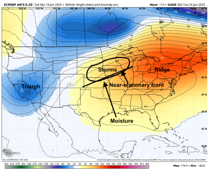
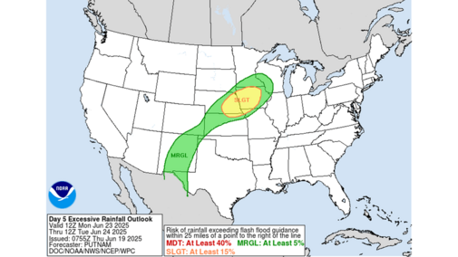
This near-stationary boundary (as shown in Figure 3) will be the focal point for multiple rounds of showers and storms starting Monday night through early Thursday, June 26 — possibly even beyond that — for central and eastern sections of the state. This setup of a stout eastern ridge, western trough, and near-stationary front over our region is a very good recipe for heavy rainfall. That some places will get excessive amounts of rain between Monday afternoon and Thursday evening is not the question. The biggest question will be where.
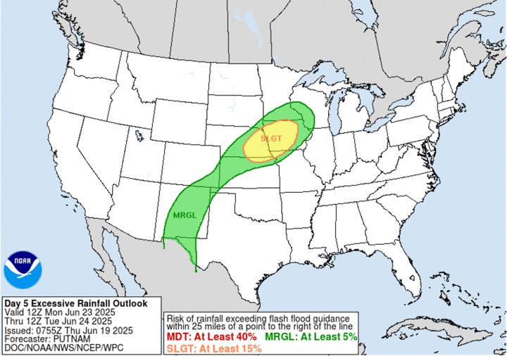
Monday night could be quite wet for much of south-central and eastern Nebraska, and severe weather may be possible too. The WPC does have much of the eastern half of Nebraska and western Iowa in the slight risk category for excessive rainfall.
Where storms develop in subsequent days will be highly contingent on where the boundary is sitting, which will be influenced by the broader upper-level flow and convective out flow. It seems possible it could get as far south as the northern end of the Kansas City metro area on Monday night before retreating north during the day on Tuesday, June 24, and then retreating back to the southeast on Wednesday night, June 25. This may focus the heaviest rainfall north of Highway 30 on Tuesday and south of it on Wednesday night into Thursday.
Regardless, areas between Highway 136 and Highway 20 in central eastern sections of the state have a chance at getting several inches of rain this week. I feel reasonably confident some places will get over 6 inches of rain in the eastern third of Nebraska, but I have little confidence in where that may be. How warm temperatures get in the afternoons and the location of storms/excessive rainfall potential hinges on this boundary.
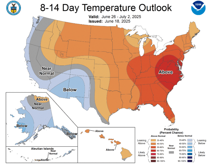
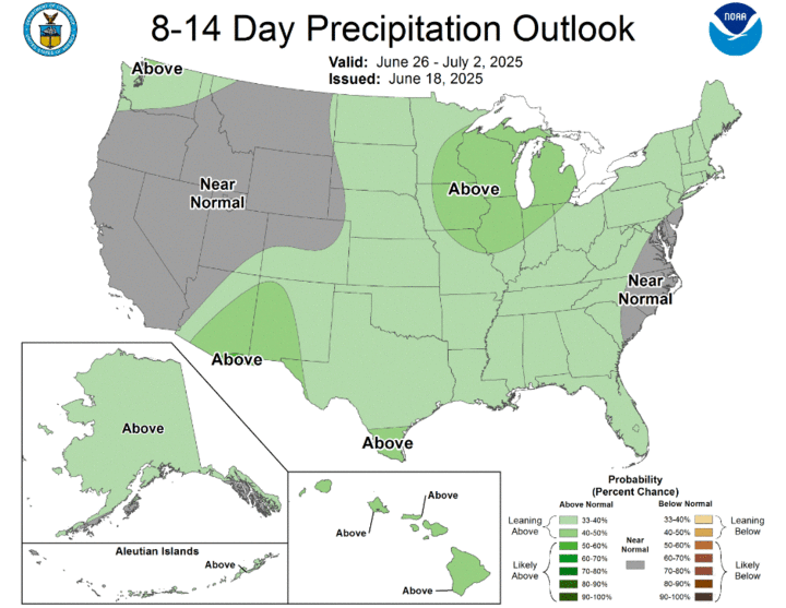
Temperatures should remain on the cool side through mid-week in western Nebraska, with a return to more seasonal temperatures by later in the week. There also will be chances of moisture between Tuesday night and Thursday morning, especially in the eastern Panhandle and Sandhills. But the heavier rain should remain east of Highway 83. Temperatures will be seasonal to seasonally warm later in the week statewide, with some chance of showers and storms in the northern section of the state. The CPC shows warmer and wetter than average favored to close out the month.