Good Chance of Moisture
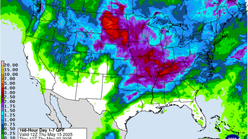
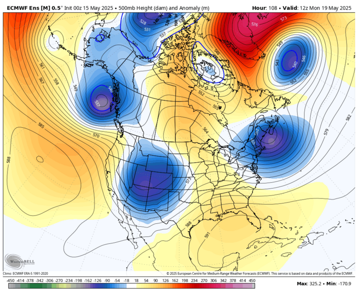
It's been a very dry spring for most of the state and many areas haven't had anything measurable in almost two weeks. Some places have barely registered a quarter inch in the last 40 days. The good news is that there is a strong possibility of getting an inch or more of moisture across most of the state early next week. The responsible party for the moisture chances is a trough moving from the western U.S. into the Central Plains, and there will be a couple of different shortwaves coming around the base of said trough into our region to help produce the rising motion needed for precipitation.
The first shortwave and associated surface low will move into the state from late Sunday, May 18 into Monday, May 19 and that will bring a good chance of rain to most of the state starting Sunday afternoon. Chances for significant moisture in western Nebraska are best in the Panhandle and Sandhills and lowest in the southwest corner where the duration of precipitation may be shortest. Further east, chances for rain Sunday night and Monday morning are looking quite good as well and may be significant for many if the low-level jet is as enhanced as it is currently depicted by the models.
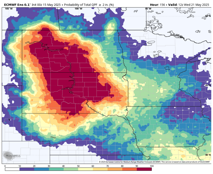
There likely will be some break during the day on Monday for most of us and then chances will increase again on Monday night into Tuesday, May 20, particularly in the eastern two-thirds of the state. Exactly where the surface low tracks and how quickly it moves will determine how much precipitation falls in central and eastern Nebraska. There is a good chance of an inch for all but the southwest early next week. Two inches is possible by next Wednesday morning, May 21 in central and eastern Nebraska and reasonably likely across much of the Sandhills where some precipitation is falling. Some areas in the Sandhills received significant moisture Wednesday night and this would be outstanding supplemental rainfall. This would be very needed rainfall for crops in central and eastern sections of the state.
The main concern is that some portion of the precipitation may be more convective in nature, which means that some areas may possibly get several inches of moisture, some spots will get 1-2 inches, and a few unlucky souls may pick up less than an inch. The good news is the moisture return does look significant and there may be a period of more steady showers on the back side of the system on Tuesday into Tuesday night.
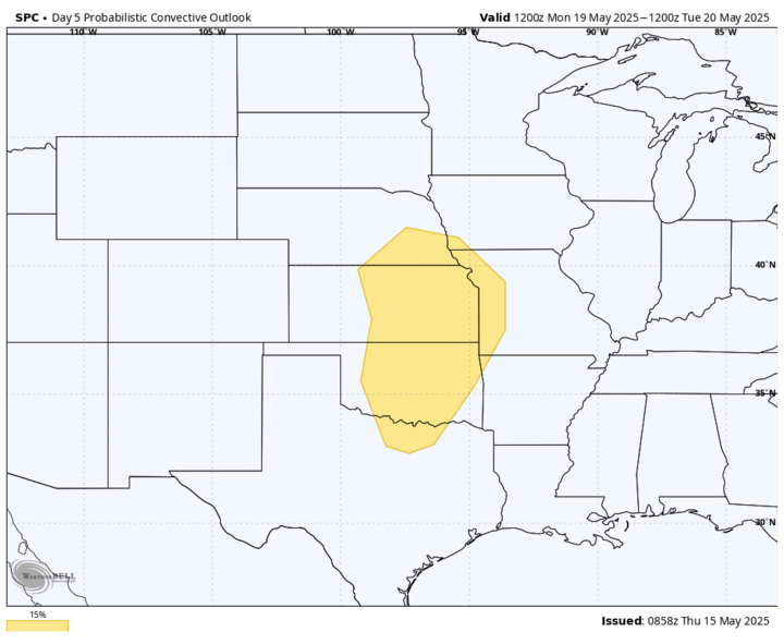
Severe Storms
The bad news is there will be a chance of severe weather on Sunday evening across southwest Nebraska and on Monday afternoon and evening across south-central and eastern Nebraska. The SPC already has that area in the Day 4/5 convective outlooks for severe weather potential. Monday evening may need to be watched carefully if the surface low, cold front and dry line intersection is in south-central Nebraska and the dry line between moist air to the east and dry air to the south and west is sharp. Largest threat would be large hail, but tornadoes can't be ruled out. Recommend keeping an eye on this as we get into the weekend. We certainly need the rain but not the damaging hail and winds.
Cooler Temperatures
With the passage of the cold front, temperatures have dropped off compared to yesterday and will be at or below seasonal averages for most of northern and western sections of the state. Will still be a little above average in southeast Nebraska but around 10 degrees cooler than May 14. Temperatures should be mostly in the 60s and 70s statewide Friday with coolest temperatures (upper 50s) confined to the north-central section of the state where cloud cover will be more prominent and showers will be possible.
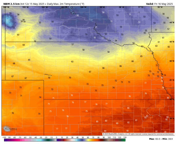
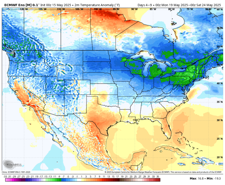
Temperatures will rebound somewhat across the western and northern sections of the state on Saturday and likely will be back into the 70s everywhere except the western Panhandle on Sunday. A cold front will start moving through the state on Monday and will set up a sharper east-west temperature gradient by Monday afternoon as temperatures likely will be in the lower 80s from Hastings to Plattsmouth and may struggle to get to 50 in the northwest Panhandle. Temperatures more likely to be in the 70s ahead of the front north of Highway 30.
Temperatures will be cooler after the frontal passage and by Wednesday, highs are likely to only be in the 50s and 60s statewide. They will rebound some by next weekend but with the cooler overnight lows, average temperatures are expected to be below seasonal averages for the back half of next week. A light freeze will be possible in the higher elevations of the Panhandle next Wednesday and Thursday mornings.
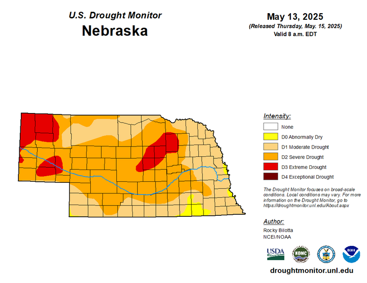
Over 60% of State in Severe Drought or Worse
The latest U.S. Drought Monitor was released Thursday morning and for the second week in a row, it showed a wide expansion of severe drought. This time the expansion was focused on east-central and parts of northeast Nebraska with places like Norfolk, Aurora, York, Seward, Stromsburg, Clay Center and Lincoln going into D2.
Drought was introduced to a broad area of the eastern side of the state (as a step down from abnormal dryness) in places like West Point, Oakland, Bellevue and Wahoo.
Extreme drought was introduced into the southeast Panhandle between Sidney and Oshkosh and also from east of Broken Bow into Ord and Bartlett in the Sandhills. Degradation also occurred over the previous week in southwest Nebraska with Chase and Dundy counties going into drought and severe drought expanded from North Platte down to McCook.
Atmospheric Greed
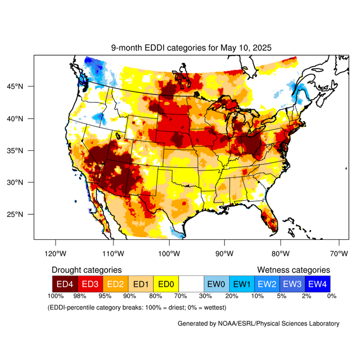
Last week I covered the precipitation deficits more thoroughly and those continue to get worse across southern and eastern sections of the state. Thankfully, most of north central and western Nebraska received precipitation over the past 24 hours, significant in some cases, so that may help stave off degradation for a bit and possibly allow for pockets of improvements depending on what happens in the next four to five days. But this week I wanted to discuss a variable that probably deserves more attention: potential evapotranspiration.
Potential ET takes into account factors like temperature, humidity, radiation and wind speed to determine how much water could evaporate in a day from a well-watered surface. It is essentially a way of determining how "thirsty" or "greedy" the atmosphere is.
The Evaporative Demand Drought Index (EDDI) is not a pure drought index per se, but it does allow us to see where atmospheric demand has been abnormally high (ED0-ED4) or abnormally low (EW0-EW4) over the previous weeks and months. Areas with persistently high levels of potential ET show up in the more extreme drought categories on an EDDI map and such is the case for almost all of Nebraska dating back to last August.
According to EDDI, the potential ET for the state is top fifth to top second percentile over the last nine months. The acuteness of the abnormally high ET combined with longer periods of dry weather (i.e., lack of precipitation) has led to a rapid increase in drought conditions across the state since last summer. It means the precipitation that did fall was used up even more quickly than usual, which helped dry out soils even faster. More on soil moisture in a minute.
One concern we have with a warming planet is that atmospheric demand for moisture could more than offset any marginal increases in precipitation. That will make recovery from drought more fragile and allow for more rapid swings from very wet to drought. That is why regenerative practices that can increase organic matter and water holding capacity are so critically important: you can keep more of the water that does fall from the sky and have it longer.
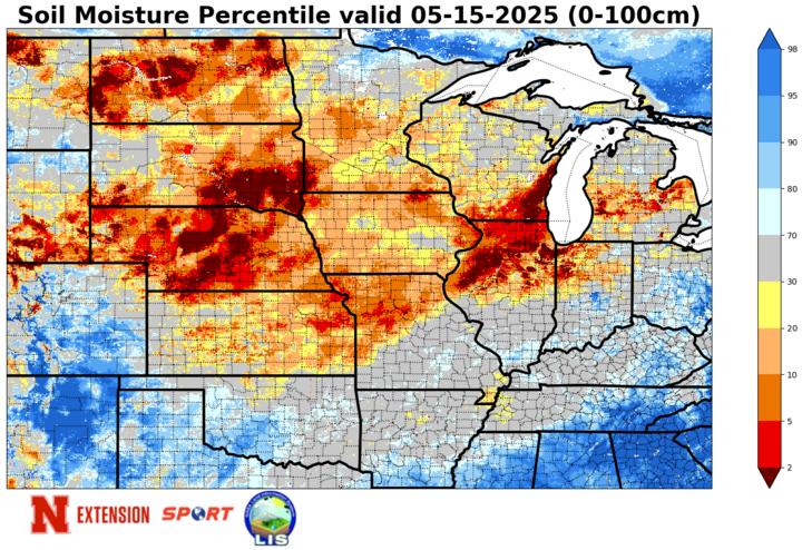
Soil Moisture Percentiles
That is the most logical reason for soil moisture percentiles persisting at percentile levels that are lower than what one would expect based on precipitation over the last several weeks to months. Soil moisture percentiles according to SPORT LIS are generally under the 10th percentile statewide as of yesterday and in many cases are under the 5th percentile. Many areas in north-central Nebraska will likely see some improvement after picking up significant precipitation last night. But the rest of us will have to wait until next week for the possibility of getting improvement.