Bottom Line Up Front
Rain chances statewide starting Friday, May 23 through Monday evening, May 26. Best chance at picking up over an inch in the northwest Sandhills. Severe storms possible Friday afternoon in southwest Nebraska. Rain will be more persistent in the western third of the state over the weekend. Eastern section of the state likely to be dry both Saturday, May 24 and Sunday afternoons/evenings, May 25. Rain chances statewide on Memorial Day, though the position of the upper-level low will dictate how much rain (if any) falls. Cooler temperatures will be the rule the next several days, though Saturday afternoon may be in the 70s in southeast Nebraska if the sun is out. Warm temperatures likely to return by month's end.
Rain and Storm Chances May 23
Our sensible weather in the coming days will be dominated by being "squeezed" between a trough to our east and a ridge trying to build to our west in the upper levels. At the surface an area of high pressure will be prominent over the Great Lakes region, which will mean more easterly flow coming into Nebraska. The combination of the upslope flow and subtle shortwaves passing through over the next several days, there will be periodic chances for rain and some thunderstorms starting Thursday night for most of the state.
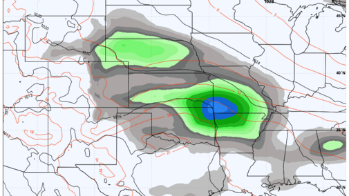
Precipitation is expected to develop Thursday night across the northern Panhandle and slide east-southeast into north-central and eastern sections of the state Friday morning. Additional precipitation may develop early Friday afternoon in the eastern side of the state in an area of more enhanced rising motion associated with a relative low level jet maximum, though models are not in agreement in placement of that or the best precipitation. Area most likely to see over a quarter inch Friday afternoon will be across northeast Nebraska but that possibility will exist along and east of Highway 281.
Clouds and scattered showers will keep temperatures down Friday across most of the state, but areas west of North Platte will see more sunshine tomorrow and temperatures should exceed 70 in the Panhandle and southwest corner.
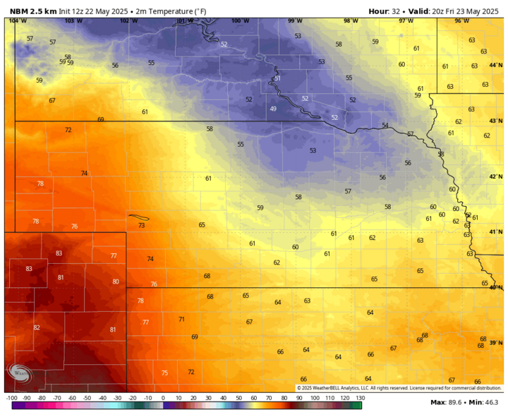
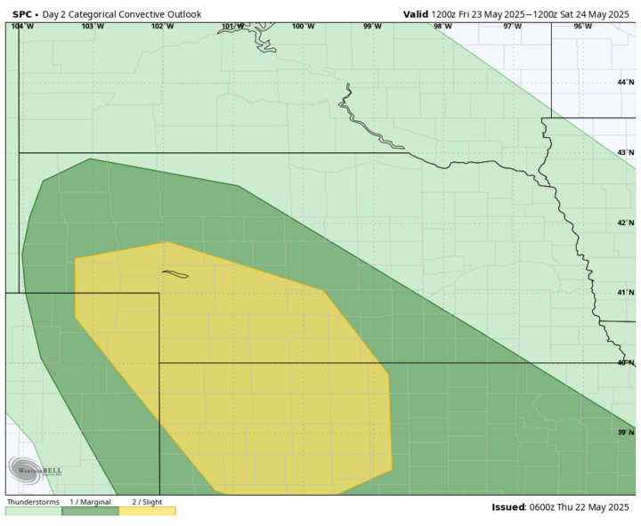
However, there will be increasing low level flow throughout the day, which will create a sharp gradient in dewpoints between the western Panhandle/northeast Colorado and southwest Nebraska. This dry line will be a focal point for possible severe thunderstorm development later tomorrow afternoon and early evening. The SPC does have this section of the state in a slight risk for severe thunderstorms. Upper-level support is not impressive, so storms may be fairly isolated and the severe risk will diminish overnight and probably won't extend beyond this area of the state.
Wet and Cool Weekend?
Surface high pressure will remain anchored over the Great Lakes region through the weekend. The continuation of upslope flow will allow for continued chances of moisture, particularly across western Nebraska. Right now, it appears that precipitation will develop across eastern Wyoming and the Panhandle on Saturday morning and gradually work its way into the central section of the state by Saturday night.
Precipitation may make its way into eastern Nebraska Saturday evening into Sunday morning, but it is possible — if not probable — that areas east of Highway 81 will remain dry during the day on Saturday, as drier air coming in from the east may be hard to overcome. Condensation and precipitation formation due to upslope flow is most favorable in the Panhandle due to the higher elevation.
Additional scattered showers will likely develop on across western Nebraska later Saturday and move into central and parts of eastern Nebraska through early Sunday morning. Precipitation may linger into the day Sunday in western Nebraska but likely will be over for most of central and eastern Nebraska.
Temperatures will be below average this weekend, especially in western Nebraska where rain and clouds will hold down temperatures in the 50s. It is possible southeast Nebraska could sneak in some sun on Saturday afternoon and see temperatures get closer to seasonal averages in the low 70s. Sunday looks to be cloudy statewide, even where precipitation isn't falling, so that will likely hold temperatures below 65°F statewide.
In other words, weather for outdoor plans on Sunday afternoon east of Highway 183 may not be ideal with cloudy skies, but it probably will be dry.
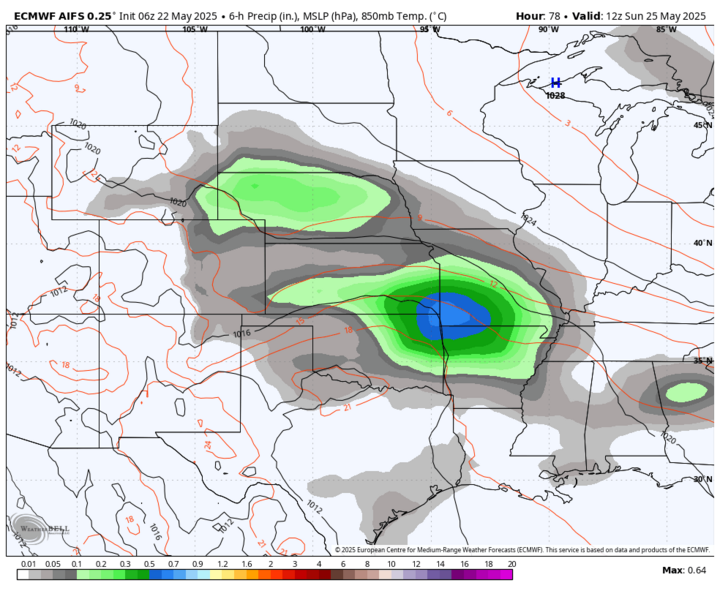
Attention then turns to an upper-level low that may be taking a more northeastward turn into the central Plains on Monday. If it takes the track suggested by the ECMWF AI model, Memorial Day will be a wet one for most of us, and the southeast quadrant of the state has a reasonable chance of picking up between a half inch and an inch. Central and northeast Nebraska would likely be in the quarter- to half-inch range, with amounts under a quarter inch most probable in western Nebraska. It also would be quite cool for late May, with temperatures holding around 52-56°F statewide in the afternoon. This solution is not a guarantee, but it will be worth watching. The rain would be a bummer for those wanting to enjoy outdoor activities, but a steady rain with cooler temperatures would be a godsend for areas with deficient soil moisture.
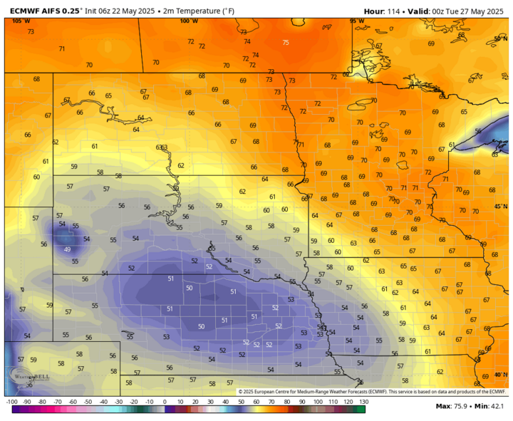
If that upper-level low stays further south, precipitation would most likely be confined to the south-central and southeast parts of the state, with amounts generally under a quarter inch. It also would be less anomalously cool across the state, though highs would still likely not get much above the low to mid-60s with cloud cover being more persistent. Rainfall should be done by Tuesday morning, May 27 regardless, but if that upper-level low cuts off for a few days in the Western Corn Belt, clouds and cool temperatures would persist through at least Tuesday and possibly into Wednesday, May 28.
Ridging and Warm Weather Return
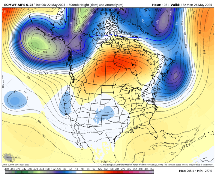
Upper-level ridging should be in place over the north-central U.S. later next week, which will bring seasonally warm temperatures in the 80s back to the state by next Saturday, May 31. Back half of next week generally looks dry as well, with only slight chances for additional moisture.
Models hint at a stronger trough and associated cold front paying the state a visit around June 3-4. If that verifies, there would be a good chance for showers and storms across the state with significant precipitation possible. But that is still close to two weeks out, so confidence is not overly high.