September 19, 2008
With the end of the 2008 crop production season rapidly approaching, it's time to analyze recent weather events and their potential impact on yields, harvest activity, and soil moisture recharge for the 2009 production season.
Precipitation
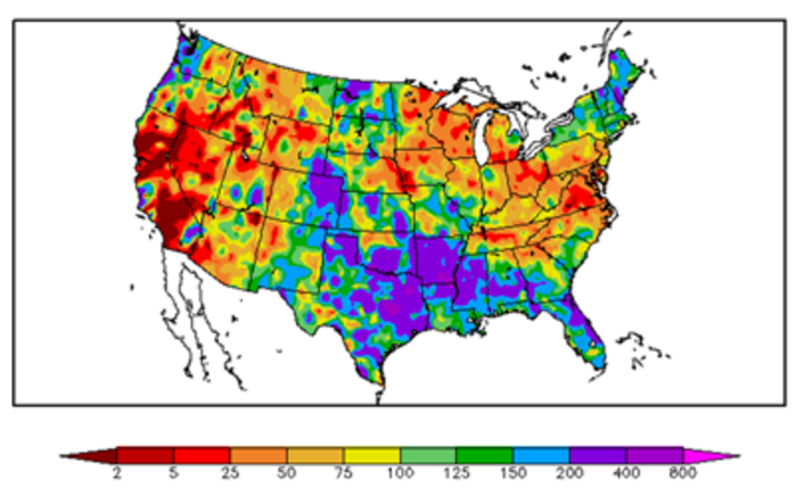
After excessive spring rains caused considerable planting delays across much of the U.S. Corn Belt, dry weather engulfed much of the region from mid-July through mid-August. An extensive area of eastern Nebraska, the eastern Dakota=s, Minnesota, Wisconsin, Iowa, eastern Illinois, Indiana, Ohio, and southern Michigan received less than 50% of normal moisture, with isolated areas seeing less than 10% of normal precipitation.
Producers in Nebraska, Ohio, and Indiana reported corn fired to ear level, ear tip back in excess of an inch, premature maturation, and poor nitrogen uptake. USDA's September national yield forecast was reduced from 155 bu/ac to 152 bu/ac. This forecast doesn=t reflect the impacts of tropical storms Gustav and Ike which laid a large swath of flooding rains from eastern Texas northeast through southern Michigan.
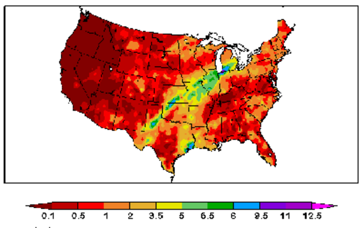
Preliminary reports after hurricane Ike=s landfall in eastern Texas indicate extensive flooding in Missouri, Illinois, western Indiana, and southern Michigan where rainfall totals in excess of 6 inches were observed within a 24-hour time frame.
As Ike moved swiftly across this region, prolonged wind gusts over 60 mph flattened large swaths of corn acreage across Missouri, southern Illinois, and southern Indiana. Further USDA corn yield reductions are probable as excess moisture may allow increased disease problems and delay harvest.
Closer to home, welcome moisture the past two weeks has virtually eliminated short-term dryness across eastern Nebraska. Several rounds of precipitation between Sept. 6 and Sept. 13 distributed two to four inches of moisture across the region. The moisture resulted from a slow moving cold front in combination with moisture from tropical storm Lowell.
Soil Moisture
Recent precipitation across Nebraska has virtually eliminated short-term soil moisture concerns. Soil moisture monitoring sites in the High Plains Regional Climate Center's network indicate the top two feet of the profile for most stations are within the normal range. These projections are based upon the last 10 years of data.
Pockets of mild dryness continue across extreme southwest Nebraska, as well as the northwestern Panhandle. Current soil moisture should be ample for winter wheat seeding and emergence, but more will be needed to restore soil reserves. Normal soil moisture profiles extend westward into Wyoming. If this trend continues, a greater percentage of the snow pack accumulated this winter will runoff instead of soaking into the soil profile. Of course, the key question for this winter will be whether last winter's snow pack levels can be replicated.
Reservoir Status
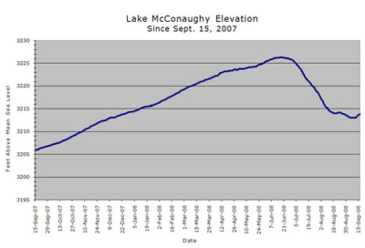
Just prior to the beginning of the snow pack runoff season in the northern Platte river basin, storage held in the four largest reservoirs (Seminoe, Pathfinder, Glendo, and McConaughy) stood at just over 850,000 ac/ft. At full pool, these reservoirs can hold 4.3 million ac/ft. By the time reservoir storage peaked in early June, 1.57 million ac/ft of water was added to the system. In other words, the reservoir system went from 20% of capacity to 56% of capacity.
With the end of the 2008 irrigation season, current combined storage in these reservoirs stands at 1.57 million ac/ft, or 36.5% of capacity. The current net year over year gain is 600,000 ac/ft. This represents the first significant storage increase since 1999. It should also be noted that if central Nebraska irrigators were allocated a full delivery of 18 inches, there would have been no net increase in storage.
Although North Platte reservoir experienced a net gain this year, it also indicates why it will take several years of bumper snow pack to bring the total reservoir storage back to full capacity. If current allocation rates are continued, it will take three to four additional years of snow pack similar to last winter before all reservoirs reach full capacity.
Current reservoir storage stands at 540,000 ac/ft for Seminoe, 349,000 ac/ft for Pathfinder, 101,000 ac/ft for Glendo, and 579,000 ac/ft for McConaughy. All four reservoirs have reached their seasonal lows and have begun to recharge. Current inflows into each of the Wyoming reservoirs are within normal range, while McConaughy inflows are 150% of normal.
Outlooks
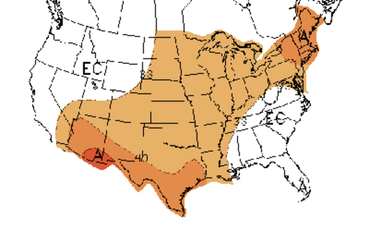
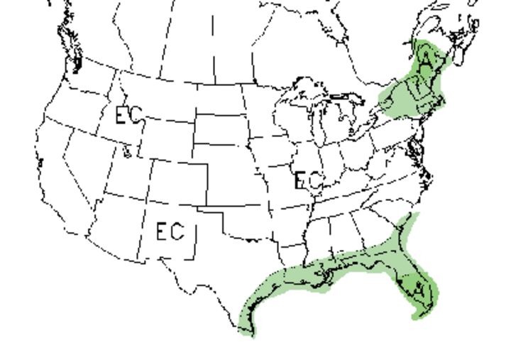
Current official forecasts for September-November indicate that a broad section of the U.S. from the southwest through the northeast is projected to have above normal temperatures. These forecasts indicate that there are equal chances of above normal, normal, or below normal precipitation across most of the country, including Nebraska. Above normal temperatures are projected to continue throughout the winter across the central Plains, with no trend indicated for precipitation.
The official forecasts have been biased toward the warm side for the past 10 months; however, across much of the central and northern Plains, monthly temperatures have been below normal most of the time. In Nebraska, statewide monthly temperatures have averaged below normal in nine of the past 10 months. Therefore, the official forecast would once again be counter to the prevailing trend.
Although we are currently experiencing a brief warm spell, weather models indicate that an extended period of cool-wet conditions will invade the central U.S. by the middle of next week. A slow moving upper air trough will move into the central and northern Rockies by the end of the week, then push into the central Plains next week. Temperatures could potentially average 10-15 F below normal through the end of the month. The moisture would be beneficial for winter wheat emergence and stand development, but the cool conditions will further delay late maturing crops.
Current projections do not indicate a freeze potential for Nebraska with this storm system. Present projections indicate the best likelihood of freezing temperatures with this trough to be across North Dakota, Minnesota, Wisconsin, and Michigan. These short-term models often change day to day, so it is not out of the question that freezing temperatures could reach Nebraska before the end of September.
What does cause concerns with this system is the slow projected movement. An extended period of moisture and cool temperatures will limit harvest. Additional moisture in Missouri, Illinois, Indiana, and Michigan will compound the excessive moisture problems from hurricane Ike. In addition, the cool-moist conditions also will affect the rate of corn dry down.
Al Dutcher
State Climatologist
