This is the fourth article of CropWatch's digital agriculture series (DA), “How Digital is Agriculture in Nebraska?” See the links below for more.
Articles in this Series:
Part 3: Barriers to Adoption of Digital Agriculture in Nebraska
Part 4: Top Five Digital Agriculture Technologies Used in Nebraska
Part 5: DAWN Dashboard: A Decision Support Tool for the Corn Belt
In this article, we would like to focus on the top DA technologies adopted by Nebraska farmers. The Digital Farming Lab, led by Dr. Guillermo Balboa, conducted a statewide survey to assess the status of DA in Nebraska. This survey identified the following top five digital agriculture technologies most adopted in Nebraska: phone apps, GPS, yield monitor and yield maps, soil grid sampling, and auto guidance.
For more resources about DA in Nebraska, visit our UNL digital agriculture website, digitalag.unl.edu, which aims to centralize all UNL efforts in teaching, research and extension on digital agriculture.
Phone Apps in Agriculture
An agriculture phone app is a mobile application designed to assist farmers, agronomists and researchers in managing aspects of crop production, livestock and resource management. These apps leverage digital tools such as GPS, remote sensing, data analytics and weather forecasting to support nutrient management, pest control, irrigation and yield prediction decision-making. Agricultural apps can help improve farm efficiency, productivity and sustainability.
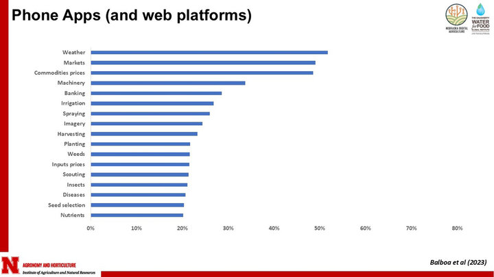
Our digital ag survey asked farmers about using different apps grouped by category. Weather, markets and commodities prices led adoption, with 50% of the farmers using at least one of them. Applications or digital platforms to manage planting, weeds, scouting, insects, diseases, nutrients or for seed selection had an adoption of less than 20% by farmers across Nebraska (Figure 2). This shows that adoption begins with applications that have lower complexity, while there is still significant potential for growth in more advanced apps that not only provide diagnostics but also support prescriptive decision-making.
GPS
Global Positioning System (GPS) technology has become a cornerstone of modern precision agriculture, enabling accurate, site-specific management of farming operations. By utilizing satellite-based navigation, GPS provides georeferenced positioning for farm machinery, equipment and sensors, allowing for precise field activities such as planting, fertilizing, spraying and harvesting. Advanced GPS systems, particularly those using real-time kinematic (RTK) GPS, offer sub-inch accuracy, which is critical for high-precision tasks.
The GPS technology has revolutionized precision agriculture by enabling site-specific management and data-driven decision-making. Key impacts include:
- Yield mapping — GPS-enabled yield monitors provide georeferenced data, helping farmers analyze within-field variability and assess crop performance over multiple seasons.
- Field mapping — Supports the creation of detailed maps that highlight key field characteristics, such as yield distribution or soil organic matter content.
- Variable-rate application (VRA) — Allows the site-specific application of fertilizers, seeds and pesticides at varying rates based on spatial variability, optimizing resource use and improving efficiency.
- Autosteer and guidance systems — Automates machine steering, reducing operator fatigue, improving accuracy and minimizing input waste.
By integrating GPS with farm machinery, sensors and farm management software, digital agriculture has become more data-driven, efficient and environmentally sustainable.
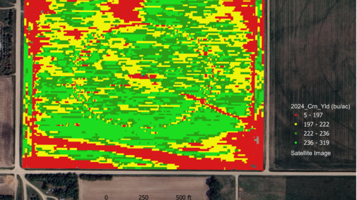
Yield Monitor and Yield Maps
A yield map is a spatial representation of crop yield variability within a field, generated using data collected from yield monitors equipped with GPS technology. These maps provide a visual summary of how crop productivity differs across a field, helping farmers and agronomists to identify patterns related to soil properties, nutrient availability, drainage and management practices. Yield maps are a key tool in precision agriculture, guiding site-specific management decisions such as variable-rate fertilization, seeding and irrigation. Yield monitors, integrated into modern combines, continuously record crop yield data during harvest, linking it to precise field locations using GPS. The data is then processed to generate a yield map, where different colors represent varying levels of productivity.
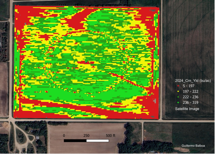
Yield monitors and yield maps have been around since the mid-1990s. Most of the current row crop combines have a yield monitor capable of generating data to produce a yield map; the use of this data to adjust field management remains relatively low. It was reported that many farmers in the U.S. have a yield monitor (+68%), but only 45% of the area was yield mapped (Lowenberg-DeBoer and Erickson, 2019).
You can access a free UNL Extension course on yield monitor data post-processing or “cleaning” here.
Soil Grid Sampling
Site-specific soil maps are commonly used in many countries as a foundation for variable rate technology. Fields are generally sampled at an average density of one sample for every three to four acres. For optimum accuracy, UNL recommends one sample per acre (composited from five cores collected in a small radius from the sampling point). Optimum grid density will depend on the site variability, the history of the field and the nutrient of interest. Grid sampling should be considered if:
- You want to produce an accurate within-field map of soil organic matter.
- Previous management significantly changed soil nutrient levels.
- Fields with different cropping histories have been merged into one.
You can check UNL recommendations in the extension NebGuide, Precision Agriculture Soil Sampling (EC 154).
Auto Guidance
Auto guidance or autosteer is a GPS-based guidance system used in agricultural machinery to automatically control the steering of tractors, combines and other field equipment. It enhances precision by keeping machinery on a predetermined path with minimal deviation, reducing operator fatigue and improving efficiency. Autosteer systems rely on RTK (real-time kinematic) GPS, inertial sensors and advanced algorithms to achieve sub-inch accuracy, making them essential for precision agriculture applications such as planting, spraying and harvesting.
By minimizing overlaps and gaps in field operations, autosteer improves input efficiency (fuel, seed, fertilizer) and ensures consistent crop rows, ultimately leading to higher productivity and cost savings. Many modern autosteer systems are now integrated with autonomous farming technologies, pushing agriculture toward more automated, data-driven farm management. You can check how auto-guidance works in the NebGuide, Precision Agriculture Satellite-Based Auto-Guidance (EC 706).
Stay tuned for our fifth article in the series, where we will highlight Dashboard for Agricultural Water and Nutrient Management, a digital tool that UNL developed in collaboration with other research universities. This dashboard allows farmers to make more informed decisions based on an accurate three-to-six-month weather forecast for the Corn Belt.
This research was supported by the Precision Nitrogen Conservation Innovation Grant (CIG — USDA NR203A750013G014). The survey was conducted in cooperation with the UNL Bureau of Sociological Research.
References
Balboa, G. R., Puntel, L. A., & Thompson, L. (2023) On-Farm Research Network Ecosystem Increased Awareness and Use of Digital Agriculture in Nebraska [Abstract]. ASA, CSSA, SSSA International Annual Meeting, St. Louis, MO. https://scisoc.confex.com/scisoc/2023am/meetingapp.cgi/Paper/150933
Ferguson, R. and G. W. Hergert. 2009. Soil Sampling For Precision Agriculture. Extension EC154. University of Nebraska. https://extensionpubs.unl.edu/publication/ec154/2009/pdf/view/ec154-2009.pdf
Puntel, L. A., Bolfe, É. L., Melchiori, R. J. M., Ortega, R., Tiscornia, G., Roel, A., Scaramuzza, F., Best, S., Berger, A. G., Hansel, D. S. S., Palacios Durán, D., & Balboa, G. R. (2022). How digital is agriculture in a subset of countries from South America? Adoption and limitations. Crop and Pasture Science, 74, 555–572. https://doi.org/10.1071/CP21759
Lowenberg-DeBoer, J., Erickson, B., 2019. Setting the Record Straight on Precision Agriculture Adoption. Agron. J. 111, 1552. https://doi.org/10.2134/agronj2018.12.0779
