Sept. 28, 2015
| Table 1. Average Soil Moisture Index by USDA NASS Crop District on Sept. 28, 2015. (Districts and EPA Ecoregions Defined) | ||
| Northwest | - 2.1 | |
| North Central | 2.3 | |
| Northeast | 4.7 | |
| Central | -1.0 | |
| East Central | 3.6 | |
| Southwest | -2.1 | |
| South Central | -1.9 | |
| Southeast | 0.7 | |
| *The Soil Moisture Index (SMI) is based on the estimated field capacity and wilting point at three depths (10 cm, 25 cm, 50 cm) at Automated Weather Data Network (AWDN) sites under grass cover. The index may not necessarily be representative of conditions of a nearby field, particularly if differences in total precipitation over the previous week have been significant. | ||
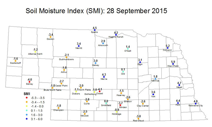
For the first time in many weeks, a large portion of the state experienced significant soil moisture improvements this week. This was particularly true over north central Nebraska and parts of central Nebraska where many locations received 2-3 inches of rain and saw the SMI go from strongly negative to solidly positive. The biggest improvements were at Sparks (-3.1 to +4.5), Ainsworth (-3.4 to 2.9), Merna (-2.2 to 4.3), and Elgin (-2.2 to 3.1). At Sparks this was the first positive SMI on a Monday map since July 13, so the precipitation there was certainly good news.
The heaviest precipitation over the past week was centered over northeast and parts of east central Nebraska, where 3 inches or more was the norm and some places received 6-8 inches. Soils are still very moist in these areas and both West Point and Concord have SMI values that indicate they are above field capacity. So rainfall in those areas is not particularly welcome, especially with the main harvest season approaching.
Unfortunately the driest regions of the state (i.e., Panhandle, southwest, south central) missed out on most, if not all, of the precipitation from that upper level low last week and SMI values generally remain in the second driest or driest category. There are decent chances of rain in those regions later this week and temperatures will be seasonally cool, so prospects for improvement look better than in the past several weeks.
Eric HuntHigh Plains Regional Climate Center