August 10, 2007
More Hot Dry Weather on the Horizon
Very humid conditions have been typical of much of the central United States during the past two weeks as an upper air ridge centered over the southern central Plains pumped monsoonal moisture from the southwest into the region. In addition, the unusually wet conditions the past few months across Kansas, Oklahoma and Texas have contributed additional low level moisture through evaporation.
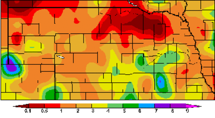
The heaviest rainfall reports for the past two weeks have come from central, south central and extreme southeast Nebraska with two-week totals ranging from two inches to eight inches. Pockets of southwest, east central and west central Nebraska and the southern Panhandle of Nebraska have seen one to four inches; however, within these areas some locations are reporting two-week totals of less than one inch. The driest areas continue to be the northern half of the Panhandle and an area along the South Dakota border from east of Ainsworth to Yankton where two-week totals have generally averaged less than a half inch.
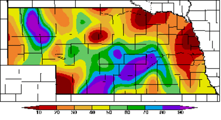
Soil moisture levels from the High Plains Regional Climate Center's Automated Weather Data Network indicate the total soil moisture profile (at four feet) across the state is showing exceptional variability. Using the scale where 0 indicates no available moisture, 50 indicates half full, and 100 indicates a full profile, much of south central, central and southwest Nebraska contains above normal soil moisture. An area of above normal moisture indicated across the eastern Panhandle should be ignored because irrigation applications around the Alliance sites are causing erroneous readings.
Dry soil moisture conditions of less than 30% of normal are evident across east central, north east, eastern north central, extreme southwest Nebraska and much of the Panhandle. Some increase in soil moisture values is expected across parts of east central and northeast Nebraska with the August 9-10 thunderstorm activity that is not reflected in the current map.
As we head through the next couple of weeks, weather models indicate that a significant spell of hot and mainly dry weather will build back into the central Plains. The only hint of moisture is across parts of southwest through north central Nebraska late on Aug. 11. Temperatures will approach and possibly exceed the century mark through August 14. Coupled with dew points well into the 60s due to the abundance of low level moisture, heat indices may approach 110°F. Livestock stress may become a significant issue during the next seven days.
At present, no major moisture has been forecast for the central Plains until at least August 19. Under this scenario, crop stress will probably become an issue in areas showing less than 50% of maximum available soil moisture levels. This would include north central, northeast, east central and southwest Nebraska, as well as the Panhandle.
The latest fall precipitation and temperature outlook by the Climate Prediction Center will be released August 16. There is evidence that La Nina conditions are finally beginning to build into the central equatorial Pacific. Under La Nina conditions, there is a tendency to experience warm and dry conditions from September to November across the central Plains. Although this would provide excellent harvest weather, it could be problematic for wheat producers, especially if little follow-up moisture occurs after this August heat wave.
Al Dutcher
Nebraska State Climatologist


