August 24, 2007

|
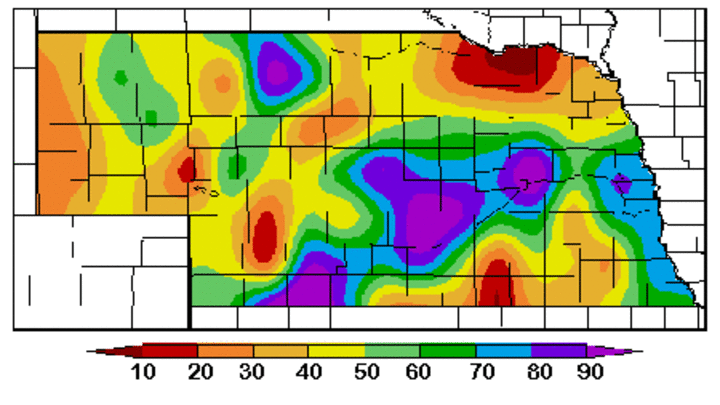
| Figure 1. Percent of Maximum Available Water in Soil Column, August 15-21, 2007. (Source: High Plains Regional Climate Center) |
With fall wheat planting rapidly approaching, it's time to look at current soil moisture levels and possible weather scenarios through next spring. It is becoming apparent that the Equatorial Pacific is translating into a cold pattern, otherwise known as a La Nina. Models indicate that this designation will likely become official within the next few months.
As we head into this La Nina event, soil moisture levels across the state are showing tremendous variability. Soil moisture levels (Figure 1) in the top four feet of the profile are showing wet conditions across southwest, central and south central Nebraska with readings ranging from 50% to 90% of field capacity. In addition, recent rains have brought some areas of east central and southeast Nebraska into the 50% to 70% of normal range. For typical soils in these regions, each 10% increment is equivalent to 3/4 of an inch of available moisture.
Unfortunately, much of the Panhandle, north central, northeast and a sliver of south central Nebraska have soil moisture levels ranging from 10% to 40% of field capacity. The worst depicted areas include extreme northeast Nebraska and the western half of the Panhandle. Another pocket of dry conditions is being reported across portions of south central Nebraska from Geneva east-northeast to southern Lancaster County.
The recent storm activity that has been responsible for localized heavy rainfall and severe weather should help improve conditions across the dry areas in eastern Nebraska, but not provide significant relief for the Panhandle. Weather models indicate that a significant cool down will occur during the next 10 days, with another round of potentially heavy rain August 28-30.
Longer term, the National Weather Service's Climate Prediction Center (CPC) is projecting that September will bring equal chances for above normal, normal, or below normal temperatures and precipitation to the central Plains. The September through November forecast indicates above normal precipitation for most of the Panhandle, with equal chances of above normal, normal, or below precipitation for the rest of the state. Fall temperatures are projected to be above normal for most of the United States, including the Central Plains.
The CPC temperature forecast through next May indicates above normal temperatures in every three month forecast for the central Plains. It appears that the temperature forecast may be a persistence type projection, since the vast majority of our winters during the past ten years have averaged above normal. Equal chances of above normal, normal, or below normal precipitation are predicted through next May.
Based on the CPC forecast, it is virtually impossible to predict how soil moisture levels will fare heading into spring planting since the CPC gives equal chances for above normal, normal and below normal precipitation for the region. If normal precipitation materializes, most of the eastern two-thirds of the state will have adequate soil moisture. Below normal moisture will certainly be a concern to the Panhandle, as well as other abnormally dry areas across eastern Nebraska (those with less than 50% of normal soil moisture).
Al Dutcher
Extension State Climatologist, Lincoln
