April 18, 2008
Old man winter delivered his waning blows to the state during the past 10 days as two systems rolled through the central Plains, resulting in moderate to heavy snow accumulations across broad areas of western Nebraska. Almost a foot of wet snow was reported north and east of North Platte, with six or more inches observed from southwest through north central Nebraska.
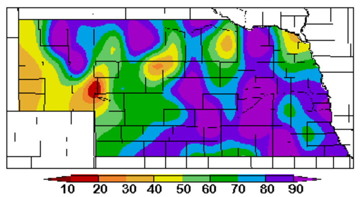
Two-week liquid-equivalent precipitation totals for most of the state ranged from 1.5 to 3 inches, helping to replenish top soil moisture. The High Plains Regional Climate Center soil moisture monitoring network indicates that the percent of available soil moisture (Figure 1) in the top four feet of the profile has improved significantly in the past two weeks.Soil profiles for all areas east of the Panhandle are at least at 50% of capacity. The isolated dry pockets in Figure 1 are a result of using a seven-day average which includes several days prior to the onset of the major winter storm that battered western Nebraska. In addition, the dry spot immediately west of Ogallala should be ignored as the sensors at shallow depths are providing false readings.
Much of central and eastern Nebraska is showing 80-100% of available capacity, indicating that little, if any, room exists for additional moisture in the short term. Any moderate to heavy precipitation over the next couple of weeks will create saturated surface conditions, leading to above normal runoff and additional planting delays. For western Nebraska, the increase in surface moisture will provide adequate moisture for crop emergence, but additional moisture will be needed to build up moisture reserves in the 2-4 foot subsoil layer.
Regional Report
East of Nebraska, saturated soils are the rule, not the exception. As of April 14, Iowa reported statewide topsoil moisture at a 50% surplus level, with the eastern third of the state reporting up to 82% in the surplus range. In addition, 38% of the subsoil is rated surplus, with up to 56% of the eastern third of the state in the surplus range. In Illinois it's even wetter with 72% of the topsoil moisture rated as surplus. Only one area in the northeastern quarter of the state is rated below 50% surplus.
As of April 14, less than 1% of the acreage in Nebraska, Iowa, and Illinois had been planted to corn. Illinois typically expects to see 10% of the acreage planted by this time, increasing to 30% by April 20 and 55% by April 27. Survey reports indicated that it would take a minimum of seven consecutive moisture-free days before significant planting activity would begin. Unfortunately, another strong storm system is expected to bring heavy rain to most of Iowa and Illinois this week, further delaying planting.
Soil Temperatures Warming
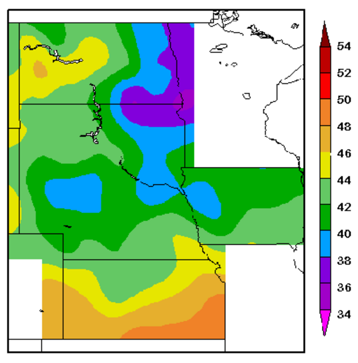
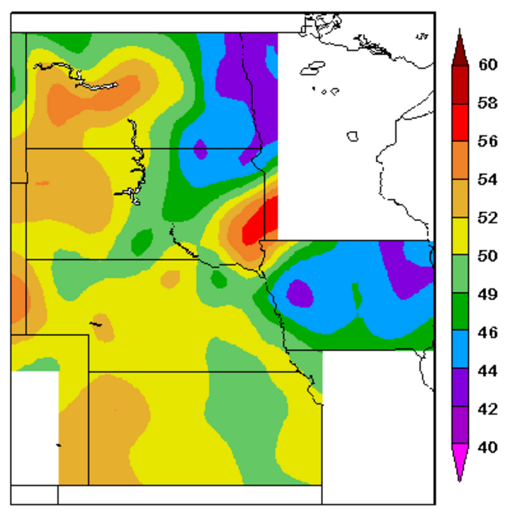
High winds April 15-16 across Nebraska helped dry soil surfaces and warmed soils. The most current seven-day average bare soil temperatures (Figure 2) at the four-inch depth were 38-42°F in the northern two-thirds of the state, with the southern third in the 42-46°F range. However, the latest one day soil temperature map (Figure 3) indicates soil temperatures have warmed to 50-54°F, except for northeast Nebraska, which was in the 46-50°F range.
Forecast
During the next two weeks, medium range models indicate several storm systems will impact the central United States. Currently, the best opportunities for precipitation are April 21, April 24-26 and April 28-May 2. Models are especially aggressive with moisture during the last two periods, with an above normal likelihood of flooding east of Nebraska, indicating significant planting delays for Iowa and Illinois into early May.
Al Dutcher
State Climatologist


