Fire Danger and Warm Temperatures
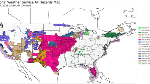
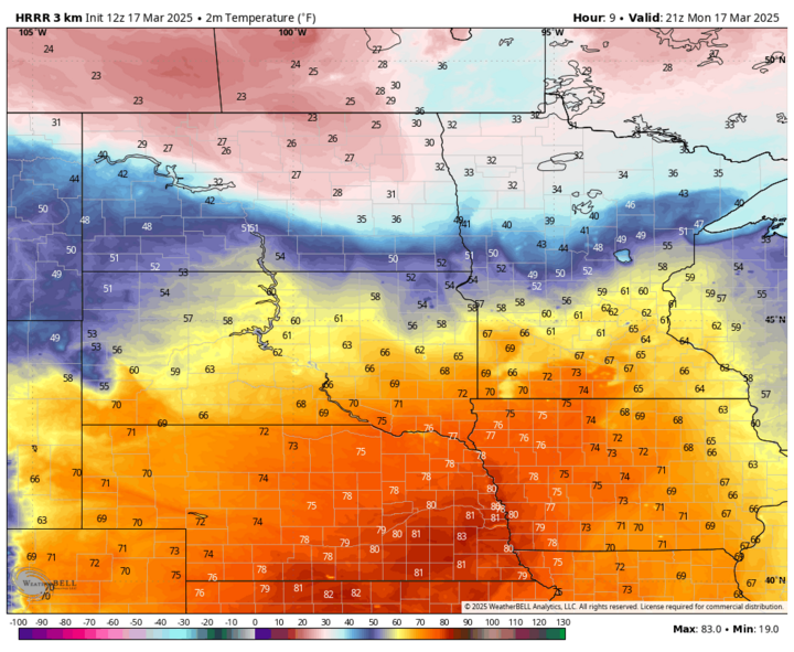
Fire danger is elevated across the entire region with red flag warnings covering the entire state, with the exception of the southwest corner where winds will be lighter. Relative humidity levels will be under 20% for much of the region this afternoon as temperatures climb in the 70s in the Panhandle and Sandhills with 78°F-86°F elsewhere. Wind speeds will be in the 15-25 mph range statewide. Warmest temperatures look to be from Grand Island over into western Iowa.
Frontal Passage Tomorrow
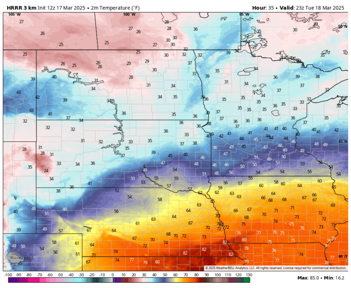
A strong cold front will be entering the state Tuesday, March 18 and it will be noticeably cooler across most of the Panhandle and across the western and northern sections of the Sandhills. Highs should still climb into the 60s across northeastern Nebraska and temperatures should get into the 70s in areas along and south of the Platte. The 12Z run from the HRRR suggests low 80s will be possible again tomorrow from Webster County over toward Falls City. Much colder temperatures will be present in the northwestern section of the state by nightfall and that colder air will be sliding southeast Tuesday night.
Rain/Storms to Blizzard
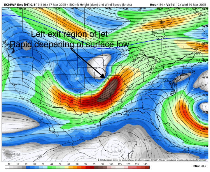
The trough responsible for this event will be moving into the Central Plains on Tuesday night and jet dynamics will once again be favorable for explosive development of a surface low. By Wednesday morning, March 19, the surface low should be around St. Joseph, Missouri and will move east-northeast through the day.
Precipitation will start late Tuesday afternoon in the Panhandle in the form of rain before quickly changing over to snow. Precipitation will work its way east through the evening and overnight hours. Snow should be in North Platte and Ainsworth by midnight and should be into Holdrege, McCook, and the Tri-Cities before 5 a.m. on Wednesday. Winds will pick up from the north and northwest through the night in those areas.
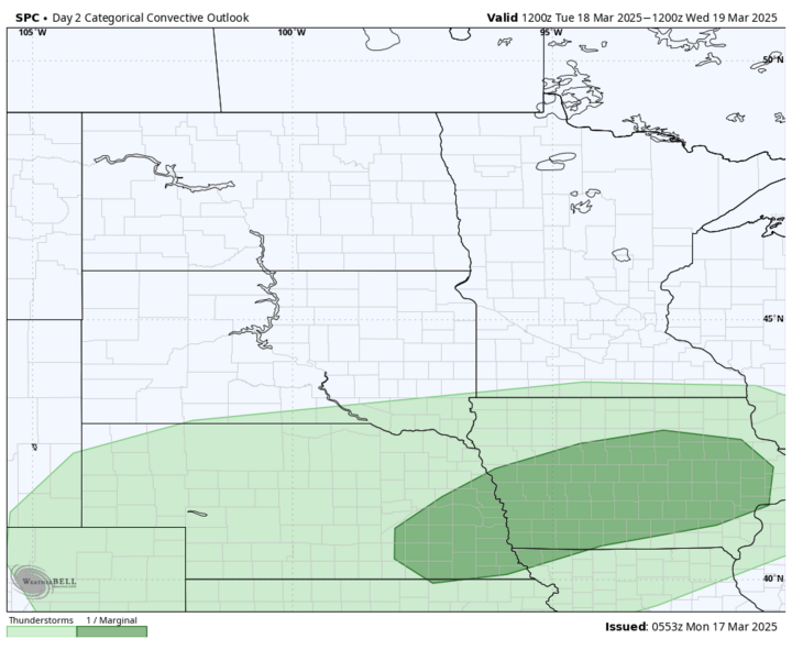
Rain and the potential for a strong storm will be possible across eastern Nebraska between midnight and 5 a.m. SPC currently has much of southeastern Nebraska in a marginal risk for severe storms tomorrow night along and north of a boundary that will be present around Highway 136.
As the surface low moves to the east and northeast, rain will change to snow in eastern Nebraska and will be heavy for the first few hours after it starts. Winds will pick up in intensity from the north and northwest during the early morning hours with sustained winds over 30 mph likely in the eastern half of the state. Snow rates of 1.0-1.5 inches per hour will be possible in places like Geneva, Crete, Beatrice, Lincoln, Wahoo, Omaha, West Point, Colmbus, Norfolk and Blair on Wednesday morning. With wind gusts in the 50-60 mph range, this could mean almost whiteout conditions on Wednesday morning during the normal morning commute. Travel likely will be difficult across much of central Nebraska on Wednesday morning too, but it may be almost impossible in the east for a few hours. This will be a wet snow and will accumulate on everything, including traffic lights.

Air temperatures likely will be right around the freezing mark during the most intense snow. So it is certainly possible that paved surfaces could accumulate snow more quickly than it would melt for a time. As the snow rate lessens later in the morning and air temperatures get a little above freezing, I would anticipate paved surfaces to begin to melt off as they will be mild after the very warm temperatures the next few afternoons.
Total snow accumulation of 1-2 inches is likely in the Panhandle and western Sandhills, with 3-6 inches likely across most of central and eastern Nebraska. It is possible areas between West Point and Tekamah could get the whole foot.
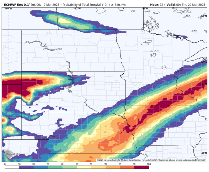
There likely will be a sharp cutoff in snow between Hickman and Falls City. Even if decent melting occurs later Wednesday in places with the most snow, there will also be high winds to contend with through the day and temperatures will drop down into the lower to mid-20s everywhere. Winds will start decreasing late Wednesday and will be much better by Thursday morning.
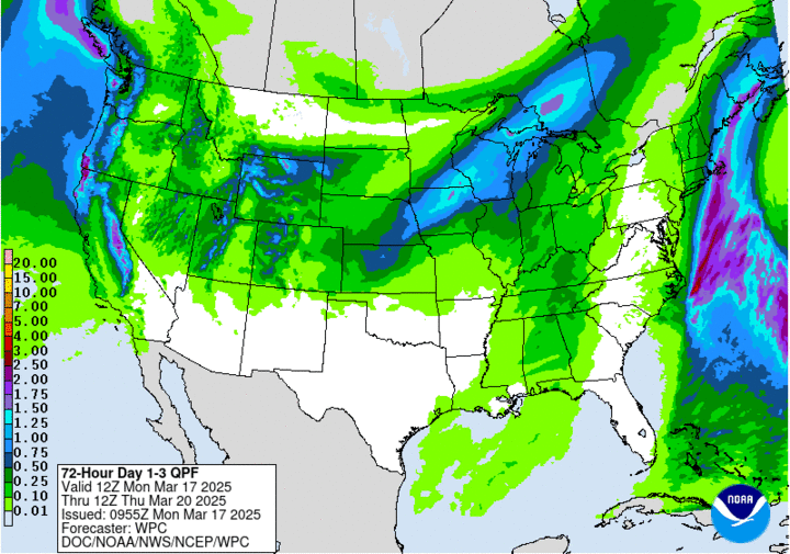
The best news out of this mess is the whole state should get some moisture with a good chance at picking up a quarter to half inch south and east of Broken Bow and O'Neill. Amounts up to an inch will be possible from Lincoln up to Oakland. Even higher amounts are possible over in northern Iowa.