|

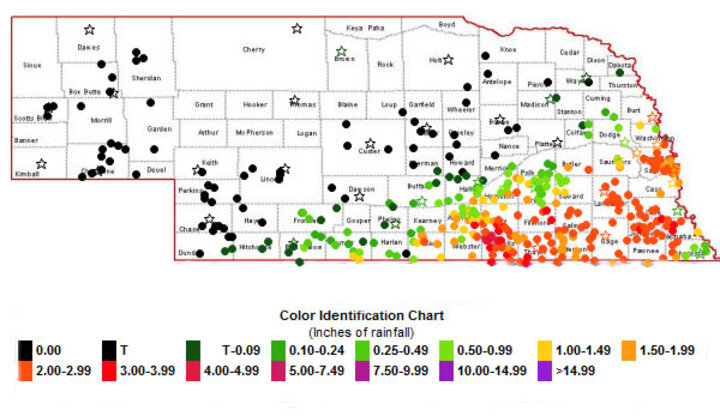
Figure 1. Precipitation amounts recorded for the June 14 rainstorm. Numerous sites reported more than 2 inches of rain, with one-day totals ranging from 4.66 inches near Lawrence to 3.45 inches near Clay Center and 2.92 inches at Lincoln. See more precipitation records on the Nebraska Rainfall Assessment and Information Network website. (Source: NERain) |
June 15, 2012
Additional timely precipitation will be critical for alleviating moisture stress as Nebraska’s corn crop approaches pollination.
|

Figure 2. A regional view from the National Drought Monitor as of Tuesday, June 12, showed expanded areas of abnormally dry (yellow) and moderate drought (tan) developing in Nebraska. |
The lack of precipitation coupled with above normal temperature during the past 30 days has resulted in a rapid expansion of drought conditions across the central Great Plains. The latest edition of the U.S. Drought Monitor, which reflects conditions through 7 a.m. June 12, indicates that moderate drought conditions have expanded to include most of the Panhandle and southwest and southeast Nebraska. A small area of severe drought conditions also was introduced into southeast Nebraska (Figure 2).
Abnormally dry conditions have been expanded to cover the Sandhills and central and east central Nebraska. The only areas not depicted with a dryness issue are most of northeast Nebraska and the northeastern portion of central Nebraska.
It should be noted that this depiction does not include the heavy rain that fell the evening of June 14 (Figure 1), occurring south and east of a line from Minden to Omaha. It is likely that the next U.S. Drought Monitor will show improvements for areas receiving more than two inches from this event.
Prior to this storm, severe crop stress was reported across the Panhandle and southeast Nebraska. A long stretch of hot, dry, windy days may have already caused significant yield reductions to dryland corn and pastures. It is too early to tell, but this rain event may have come too late to save the corn crop in southeast Nebraska along the Kansas border.
Although this precipitation was very welcome, additional moisture will be necessary to avoid further crop deterioration if hot, dry, windy weather returns. The weather models indicate daily chances of rainfall through next Thursday (June 21). Although coverage is not expected to be broad-based on any given day, many locations could receive a total of two inches over several days. With northeast Kansas and northwest Missouri already reporting the first tassels on corn planted in early April, we are likely within 7-10 days of this occurring in extreme south central and southeast Nebraska.
|

Figure 3. Percent of normal precipitation for the 30-day period from May 16 to June 14. Note that much of the Panhandle and central and southeast Nebraska had received less than 50% of normal. (Source: High Plains Regional Climate Center)

Figure 4. Departure from normal temperature (°F) for the 30-day period from May 16 to June 14. (Source: High Plains Regional Clijmate Center) |
With corn water use now estimated at 0.25-0.35 inch per day (crop stage dependent), two inches of moisture equates to six to eight days of use. Conditions have been so dry for much of the state during the past 20 days that, in the absence of rain, there is little soil water reserve to rely on. Certainly the severe leaf rolling of corn reported in several areas prior to this week’s rain is a testament to the lack of soil moisture (Figures 3-4).
Current water use estimates indicate that corn is now entering its high water demand period. At 0.25 inches of water demand per day, corn requires 1.75 inches of moisture a week. With soil moisture reserves severely depleted during the last 30 days, a distinctly wet pattern will need to be established to offset potential yield destruction. Unfortunately, no such pattern has firmly established itself during the past nine months.
Rain's in the Forecast, Followed by Heat
Current weather models are sending mixed signals for the moisture and temperature outlook. There are daily chances for moisture through late next week, followed by hot, dry conditions the next seven days as an upper air ridge builds into the central United States.
If the current models for the central plains are correct, high temperatures would persistently be in the 90s, with the distinct possibility of 100°F or higher temperatures developing across central and western Kansas. Some of this heat is likely to expand into southern Nebraska. In short, the amount of rainfall that falls during the next week will go a long way in determining whether significant heat and moisture stress continues as we approach corn pollination.
Al Dutcher
Extension State Climatologist
Al Dutcher discusses current weather conditions and the
forecast for the next two weeks in this June 15 Market Journal
segment.
