April 3, 2009
In Like a Lion, Out Like a Lion
Each month UNL Climatologist Al Dutcher reports Nebraska weather trends to state and federal agencies. Beginning with this issue of CropWatch, he'll also share them with our readers.

|
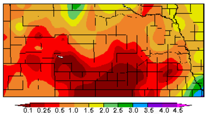
| Departure from normal precipitation averages for March. (Source: High Plains Regional Climate Center.) |

|
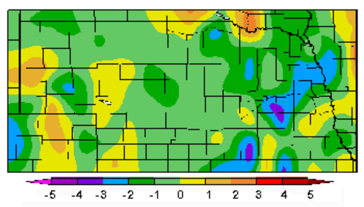
| Departure from normal temperature averages for March. (Source: High Plains Regional Climate Center.) |
Most of Nebraska experienced drier than normal conditions coupled with below normal temperatures in March. Several intense low pressure systems crossing the central United States brought blizzard conditions to northwest and north central Nebraska. While this snowfall missed southern Nebraska, it was hit by the first severe weather outbreak of the season March 23. Six tornado touchdowns were confirmed.
The trend of below normal moisture this March did not come as a surprise. For the second consecutive winter, La Nina conditions developed across the equatorial Pacific. Of the 10 La Nina episodes since the 1950s, seven were multi-year events. A statistical analysis of past second-year events indicates a strong tendency for Nebraska to experience below normal moisture in March. There is also a weak tendency for eastern Nebraska to experience below normal temperatures, while western sections of the state trend toward above normal temperatures.
Precipitation
Six precipitation events occurred in March, with the strongest event March 22-24. An intense area of low pressure moved through the region, resulting in blizzard conditions and snowfall accumulations approaching 8 inches across the northern half of the Panhandle and the Sandhills.
In the warm sector of the storm, the National Weather Service confirmed six tornado touchdowns. An F2 tornado was reported in Holt County, causing light damage to one farmstead and destroying an abandoned school. Two F1 tornadoes and one F2 tornado were confirmed in Lancaster County, resulting in minor injuries to five people from flying debris. Two additional F1 tornadoes were confirmed in Cass County. Preliminary damage estimates for the six tornadoes stands at less than $100,000.
Two additional snow events occurred in March. There were unofficial reports of 2-12 inches of snow March 7-8 from the southeastern corner of the Panhandle northeast to the eastern Sandhills region. A March 29-31 storm resulted in 2-8 inches of snow from the northern Panhandle eastward to northeastern Nebraska.
Three light precipitation events occurred March 10, 19, and 26. In the first event, less than 0.25 inch of rain fell across Richardson County in extreme southeastern Nebraska. On March 19 0.10 to 0.25 inches of moisture was reported in north central sections of the Panhandle. On March 26, 0.10 to 0.25 inches of moisture fell from Holdrege north into the southern Sandhills.
Only 10 of the 102 observation sites with at least 80% of their March data available for analysis reported above normal moisture. Seven locations were in the northern Panhandle, with the remaining locations scattered across eastern Nebraska. These eastern stations recorded most of their moisture during the March 23 severe weather outbreak.
The Salem 5 SW site recorded the greatest March precipitation with 3.13 inches and the largest 24-hour total with 1.57 inches. The largest monthly snowfall from stations having at least 50% of their data available for analysis was 13.5 inches at Chadron 3 SW. The largest 24-hour total was 10 inches at Arthur. Of special note was the complete lack of measurable snowfall for most locations south and east of a line from McCook to Omaha.
Temperatures
When strong low pressure systems frequently impact the central United States in spring, expect large temperature swings. This March was no exception. It was not uncommon to see average temperatures swing from 10-25°F above normal to 10-20°F below normal after a low pressure system passed.
The first three days of March were cold with average temperature departures running 5-30°F below normal. From March 4-9, there were above normal average temperature departures approaching 20°F. Another cool down occurred March 10-12, with average temperature departures 15-25°F below normal. During an extended warm spell March 13-23, average temperatures ranged from normal to 20°F above normal. The remainder of the month had average temperatures of 5-15°F below normal.
Of the 141 temperature sites having at least 90% of their data available for analysis, only 40 had above normal average temperatures. Average temperature approached 3°F below normal across east central and south central Nebraska.
The highest reported March temperature was 83°F at Rulo on March 18, while the coldest temperature was -18°F on March 1 at Higgins Ranch and Newport. At least 76 locations recorded at least one sub-zero reading during the month, while 23 sites reached or exceeded 80°F. Only one location out of the 142 reporting sites failed to reach 70°F.
A Windy Month
March in the central Plains is notorious for high wind events and this March was no exception to the rule. Of the 23 Automated Surface Observation sites across the state, 22 reported a peak gust in excess of 50 mph. The strongest gust of 68 mph was reported at Omaha on March 23, while the weakest peak gust was 48 mph at North Platte on March 31. Seventeen of the 23 locations reported their peak gust March 23. There were four days with average wind gusts over 40pmh in the eastern third of Nebraska, six across central Nebraska, and eight across the Panhandle and western Sandhills.
Monthly average wind speeds ranged from 10.7 mph at Chadron, North Platte, and Scottsbluff to 13.5 mph at Sidney. In general, much of eastern Nebraska experienced average wind speeds 0.5 to 1.5 mph greater than the historical mean, while western Nebraska was 0.5 to -0.5 mph below normal. Blowing dust reduced visibilities to less than two miles across areas of central and eastern Nebraska on March 23 prior to the onset of the severe weather event.
Al Dutcher
Extension State Climatologist
