Highlights
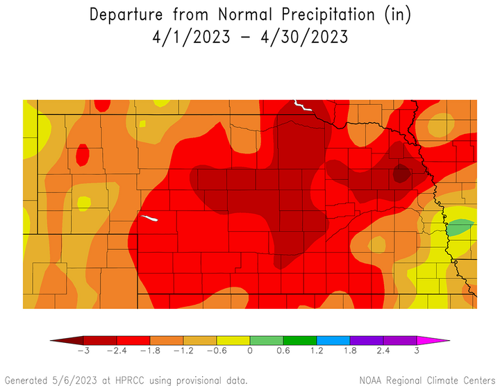
The National Center for Environmental Information (NCEI) preliminary statewide rankings indicate that Nebraska experienced the 64th coldest and fifth driest April since records began in 1895. NCEI indicates that the preliminary state average temperature for April is 48.0°F, which is 0.3°F above normal (based on the period 1991-2020). April precipitation on an area weighted basis was 0.68 inches according to NCEI, which is 1.58 inches below normal.
Above-normal April temperatures across Nebraska were influenced by an upper air trough over the western United States during the first half of the month which brought above-normal temperatures to the eastern half of the United States before switching to an upper air trough across the eastern half of the country during the second half of April. There were 15 days during April when precipitation was reported somewhere within the state. Just like March, individual precipitation events were generally light (under 0.20 inches) with little broad-based coverage.
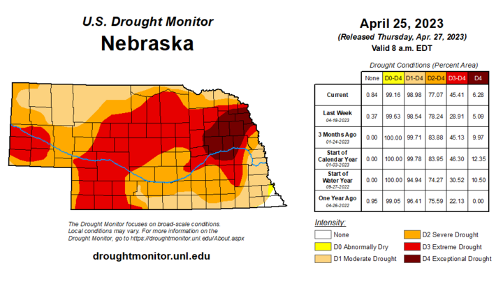
April precipitation was insufficient to reduce the ongoing drought intensity across the state and there was a one category increase in drought intensity across south-central and a small section of west-central Nebraska. Exceptional drought (D4) continued for parts of east-central and northeast Nebraska, while extreme drought (D3) conditions continue along the Platte River from Wyoming to North Platte, along with most of southwest Nebraska and parts of the eastern Sandhill region. Severe drought (D2) covers most of central and eastern Nebraska, while abnormally dry (DO) to moderate drought (D1) conditions prevail across southeast and south-central Nebraska.
Precipitation
The average statewide precipitation value for April is 0.68 inches according to NCEI, which is 1.58 inches below normal according to the current 1991-2020 comparison period. This marks the third consecutive month that the state average precipitation has been below normal, which followed two consecutive months of above-normal moisture (December and January). Precipitation was recorded somewhere in the state on an average of one out of every two days, but just like March, individual events were generally under 0.20 inches. Cumulative monthly precipitation totals were under 0.50 inches across central, south-central, southwest and west-central Nebraska, with monthly totals failing to reach 0.10 inches across a large area of west-central Nebraska. Locations east of a line from northwest Gage to Burt County received at least an inch of moisture, with areas east of a line from Beatrice to Blair reporting two to 3.5 inches of moisture.
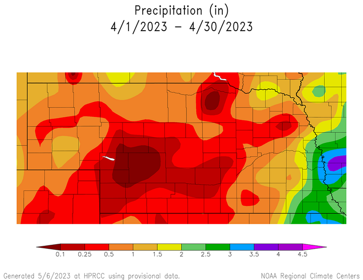
The only new record established at National Weather Service and Automated Surface Observation System (ASOS) during April was 0.71 inches of precipitation that recorded at Sidney on April 14, which eclipsed the old record of 0.68 inches recorded in 1977. The most significant precipitation and severe weather event during April occurred on April 18 across the eastern third of the state where totals ranged from 0.25 to 1.50 inches. Preliminary data from the Storm Prediction Center (SPC) indicates at least 44 hail and three windstorm events were reported. The first Nebraska storm report for hail in 2023 was reported at Preston 3 N on April 4, while the first storm report issued for wind was reported at North Platte on April 13 for a 71 mph wind gust. There were no tornado reports during April across the state, but preliminary totals indicate that at least 70 hail and 17 wind related storm reports were issued on seven different days (April 4, April 9, April 13, April 14, April 18, April 19, April 27).
The highest liquid equivalent precipitation total report from real-time cooperative weather observers during April was 3.85 inches at Beatrice 1 N and Nebraska City 2 NW, while the greatest monthly NERain precipitation total was 4.65 inches at Louisville 1.4 W. The cooperative weather observer at Chadron 3 SW reported 14.5 inches of snowfall during April making it the highest monthly total submitted from National Weather Service observers, while the highest snowfall total reported through NeRain was at Crawford 10.8 ESE with 7.3 inches. A preliminary analysis of cooperative observer seasonal snowfall totals through April 30 indicates that at least 12 stations have reported over 60 inches of snowfall for season, with Chadron 3 SW leading the pack with 86.6 inches of accumulated snowfall.
Temperature
Nebraska’s average temperature for April 2023 was 48.0°F, which is 0.3°F above normal. The colder than normal conditions across the state slowed dormancy break for native vegetation. Wheat broke dormancy during the second half of the month, nearly two weeks behind the past two years. Preliminary analysis of weather records submitted by NWS cooperative weather observers indicates that the state high temperature of 95°F was set at the North Platte Airport and Trenton Dam on April 13. At least 42 cooperative observer and/or NWS locations reported their first 90°F or greater high temperature of 2023. On the flip side, minimum temperatures dropped to 3°F on April 6 at Agate 3E and Harrison 20 SSE on April 6. The temperature spread between the highest maximum and lowest minimum temperature reported during April across Nebraska was at least 92°F and may increase once all handwritten cooperative weather reports are digitized after submission.
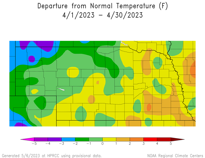
Average temperature were below normal during April across the northwestern third of the state, with most locations running less than 1°F below normal. The northwestern corner of the Panhandle averaged 2-3°F below normal, while the western edge of the Panhandle and northern edge of Sandhill region experienced average temperature departures of 1-2°F below normal. There were two areas of eastern Nebraska where average temperatures were 1-2°F above normal, a small pocket in the northeast corner of the state and a larger pocket encompassing parts of east-central and southeast Nebraska primarily along and south of the I-80 corridor from York through Cass County.
An examination of NWS and ASOS historical temperatures reveal that at least 26 temperature records were set at these locations during April, including 15 high temperature and 11 low temperature records. Twelve of the 15 high temperature records were set April 12-13, while six low temperature records were established on April 24.
Although there are too many temperature records to list in this article, there are several that are newsworthy. Grand Island set its coldest reading this late in the spring season when the low temperature reached 21°F on April 23, ending a record that has stood for 116 years. It also eclipsed the old record low of 23°F set in 1963. Record high minimum temperatures were set Norfolk (April 12, 59°F) and Grand Island (April 12 and 13, 58°F). Two locations exceeded their previous high temperatures by 7°F, North Platte and Scottsbluff. Scottsbluff reached a high temperature of 92°F on April 11, breaking the old record of 85°F in 1916 and North Plate reported a high temperature of 95°F on April 14, breaking the old record of 88°F set in 2006.
Outlook
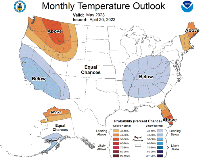
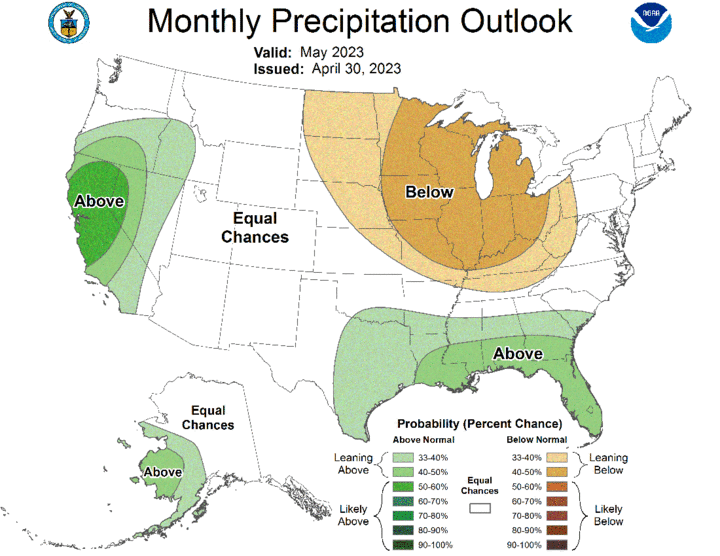
The Climate Prediction Center (CPC) released their official May climate outlooks on April 30, which indicates that there is a slight chance for below-normal precipitation for the northeastern half of Nebraska. There are equal chances for above-normal, normal, or below-normal precipitation for the remainder of the state. CPC indicates a broad area of the Great Lakes, along with the central and eastern Corn Belt region is forecast to receive below-normal moisture during May. According to CPC, above-normal moisture is likely along the Gulf of Mexico and the west coast from Oregon southward to Mexico. There are equal chances of above-normal, normal, or below-normal temperatures across Nebraska during May. Above-normal temperatures are forecast for the Pacific Northwest, the southern half of Florida and northeastern United States. Below-normal temperature are forecast for the southwestern United States, along with the lower Ohio and mid-Mississippi River valleys.
Agricultural Update
With a third consecutive month of below-normal moisture across most of the state, precipitation surpluses experienced during the December-January period have been eliminated over the past two months and precipitation deficits since the beginning of last October (soil moisture recharge period) are consistently running three to five inches below normal across a large portion of central, east-central, south-central, the western half of southeast and southern third of northeast Nebraska.
Even though topsoil conditions were dry enough to plant corn and soybeans, the colder-than-normal conditions during the last two weeks of April delayed planting due to frost/freeze concerns and/or insufficient moisture at planting depth to promote uniform stand emergence. Statewide soybean planting reached 16% according to the Nebraska Agricultural Statistics Service (NASS). Planting progress at this time in 2022 stood at 17%, while the five-year average is 13%. Corn planting progress reached 30% according to NASS, which compares to 25% at this time last year and the five-year average of 29%.
Topsoil and subsoil moisture estimates showed strong deterioration through the month of April according to NASS. As of April 30, topsoil was rated 37% very short, 41% short, 22% adequate and 0% surplus. Very short topsoil conditions expanded 21 percentage points during the month, while short conditions expanded 8 percentage points. Topsoil moisture ranked adequate shrank 24 percentage points while surplus conditions dropped 5 percentage points. Subsoil moisture rankings also dropped during the month, just not at the same intensity as topsoil moisture rankings. NASS indicates that subsoil moisture on May 31 was rated 45% very short, 38% sort, 17% adequate and 0% surplus. Compared to the beginning of April, subsoil ranked very short increased 13 percentage points and those ranked short increased 3 percentage points. There was a 2-percentage point decline in subsoils ranked adequate and a 3-percentage point decline in surplus subsoil conditions.
Winter wheat is the only crop that NASS listed with crop ratings at the end of April, with pasture conditions and individual crop ratings beginning in May. As of April 30, winter wheat was listed as 18% very poor, 33% poor, 35% fair, 12% good and 2% excellent. Compared to estimates on March 26, there was a 7-percentage point increase for wheat ranked very poor and a one-point increase for wheat rated poor. Subsequently, wheat rated good dropped 7 percentage points during the month, while wheat rate excellent shrank 1 percentage point. Wheat will begin to enter reproduction during May and precipitation events across the Panhandle and southwest Nebraska are the two agricultural districts that are responsible for the majority of wheat production in the state. If wheat conditions are to improve before harvest activity begins, it will be from above-normal moisture across the southern half of the Panhandle and western half of the southwestern agricultural district.
April Mesonet Extremes
- Highest Air Temperature: 94.4°F, Enders 10 SW (April 12)
- Highest Heat Index Temperature: 88.7°F, Indianola 8 SW (April 12)
- Maximum Wind Gust (9 feet): 53.1 mph, Scottsbluff 6 NW (April 27)
- Highest Daily Precipitation: 1.63 inches, Nebraska City 3 W (April 20)
- Highest Four-inch Soil Temperature: 97.4°F, Whitman 5 NE (April 13)
- Lowest Four-inch Soil Temperature: 28.9°F, Fordyce 4 W (April 6)
