June 8, 2007
Rebuilding Water Levels Takes Time
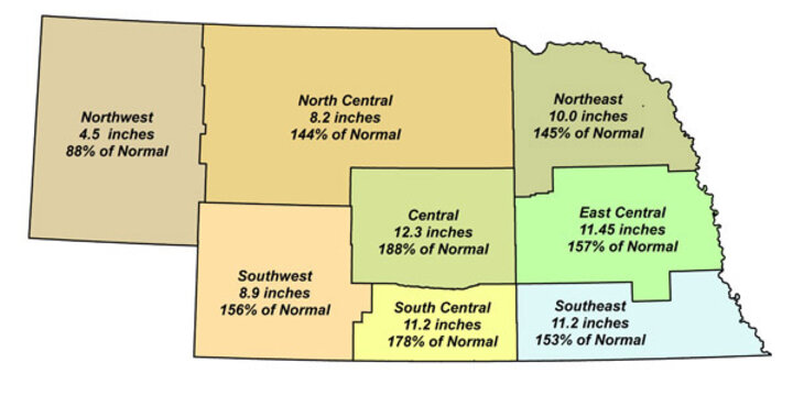
Finally, compared to the last few years, many places in Nebraska are receiving good spring moisture. Seven of the eight crop reporting districts are showing above-average rainfall for April and May (Figure 1).

|
| Figure 1. Average precipitation for April and May in 2007 compared to long-term average amounts for the Crop Reporting Districts. |
The Central District leads the way with an average of 12.3 inches which is 188% of the normal precipitation for these months, while the South Central District is close behind with 11.2 inches or 178% of normal. Most districts are averaging about 150% of the normal April and May precipitation. Unfortunately the Northwest District remains dry with an average of 4.5 inches, only 88% of average. This follows several years of severe drought in western Nebraska.
The question often arises as to how well reservoirs are recovering given the increased runoff that occurred. Of course, reservoirs receive inflow from storm runoff, but they also receive water from groundwater flowing into streams and eventually into a reservoir. Increased streamflow due to groundwater recharge from rains this spring requires a long time.

|
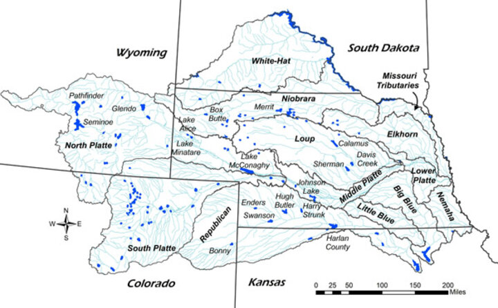
| Figure 2. Distribution of Nebraska's watersheds and location of principle irrigation reservoirs. |
We need to look at the surrounding states to understand how Nebraska is affected. We share all of our watersheds, except for the Elkhorn and Loup Basins, with neighboring states (Figure 2). The primary water supplies for the North Platte and South Platte basins occur in Wyoming and Colorado. A portion of the Republican watershed is extends into northeast Colorado. The principle reservoirs used to supply irrigation in Nebraska are also shown in Figure 2. Nebraska has little land in the South Platte River basin that is irrigated from reservoirs; however, in the Loup, Niobrara, North Platte and Republican basins, water is stored in reservoirs for irrigation.
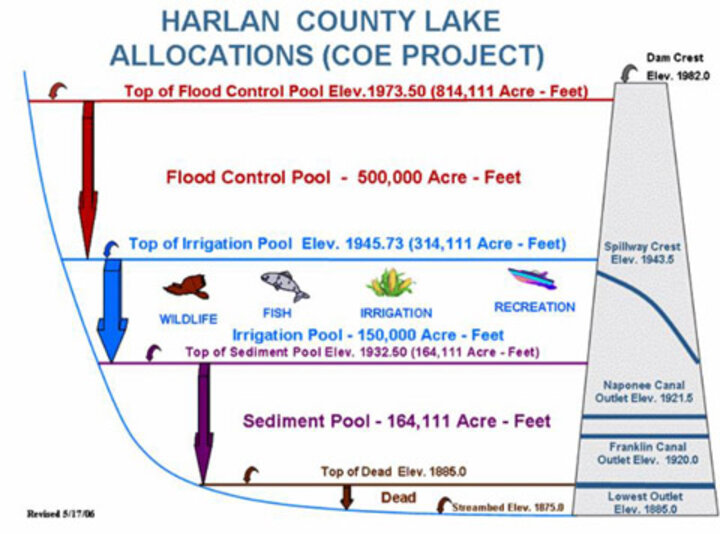
Reservoirs are built to provide several types of storage (Figure 3). Generally, there is a combination of a sediment and dead storage pool at the bottom of the reservoir. The irrigation pool lies above the sediment pool. The combination of the irrigation and lower pools often are referred to as the conservation pools or storage capacity of the reservoir.

|
| Figure 3. Illustration of storage pools for multipurpose reservoirs used for irrigation supplies (Source: from Bureau of Reclamation Great Plains Region Web site.) |
All reservoirs shown in Figure 2 also have the ability to temporarily store water to mitigate downstream damage due to flooding. For some reservoirs, such as Harlan County, the flood pool is quite large (one-half million acre-feet). An acre-foot of water is the amount of water required to flood an acre (about the size of a football field) to a depth of one foot. An acre-foot of water is equivalent to about 326,000 gallons of water. The flood pool at Harlan County Reservoir is capable of storing over 160 billion gallons of water.
The current water storage and some storage characteristics for the primary reservoirs supplying irrigation water in Nebraska are summarized in Table 1 (below). Storage data tells a different story depending on the watershed of interest. The reservoirs in the Loup Basin are nearly full and are slightly ahead of average. The Loup Rivers provide substantial baseflow (i.e., streamflow due to groundwater) and the reservoirs often fill. The Niobrara reservoirs are similar to those in the Loup with supplies for the basin at almost 85% of normal and 80% of storage capacity.
Platte Reservoirs. The Platte River reservoirs tell almost the opposite story. Snowmelt in the mountains of Wyoming and Colorado are essential to supply inflows for reservoirs in the Platte Basin. The data in Table 1 shows that watershed as a whole currently has filled about 44% of its capacity which is about 61% of the average storage at the end of May (based on the period from 1960 through 2006). The reservoirs would need about 1.2 million acre-feet of water to reach the normal amount of storage and almost 2.5 million acre-feet to fill the conservation pool for these reservoirs. Some reservoirs such as Lake McConaughy and Pathfinder are at less than half of the average storage for this time of year. Clearly, water supplies will continue to be very tight in the Platte for all water uses for the upcoming summer. Irrigation districts have reduced allocations and are working with producers to optimize the value of the water during this drought period.
Republican Basin. Water supplies have improved in the Republican Basin but the amount of storage is about 61% of storage capacity and two-thirds of the normal amount of storage. Reservoirs in the western end of the basin (Bonny, Enders and Swanson) are still quite low; while the eastern reservoirs are faring better. The recent storm runoff and groundwater recharge from above-average precipitation is starting to help in the Republican, but it has a long way to go to meet obligations stipulated in the Republican River Compact. Irrigation from groundwater and reservoirs will be curtailed to address compliance issues.
Thus, the story is mixed. Rains have increased runoff supplies to streams and reservoirs, and in many locations will eventually provide some recharge to groundwater. In many areas irrigation can be delayed this year due to the amount of water stored in the crop root zone this spring. Central Nebraska has benefited the most from these rains, while the Panhandle continues to lag behind. Recharging groundwater and filling reservoirs requires a prolonged period of enhanced supply. Returning to normal rains will certainly help many conditions; however, in other areas other factors also have to be considered. We'll keep you posted on future conditions. In the meantime, let's hope the rains continue.
Derrel Martin
Biological Systems Engineering
|
|||||||
|
River Basin |
Reservoir |
Storage Capacity, |
Current Storage, |
Ratio of Current Storage to Capacity, % |
Average (1960-2006) |
Ratio of Current to Average Storage, % |
|
|
Loup |
|
|
|
|
|
|
|
|
|
Calamus2 |
127,400 |
127,452 |
100% |
122,335 |
104% |
|
|
|
Davis Creek2 |
31,158 |
23,734 |
76% |
23,675 |
100% |
|
|
|
Sherman3 |
69,076 |
-- |
-- |
66918 |
-- |
|
|
Basin total w/o Sherman |
158,558 |
151,186 |
95% |
146,010 |
104% |
||
|
|
|
|
|
|
|
|
|
|
Platte |
|
|
|
|
|
|
|
|
|
Seminoe |
1,017,273 |
432,989 |
43% |
565,769 |
77% |
|
|
|
Pathfinder |
1,016,507 |
274,524 |
27% |
622,332 |
44% |
|
|
|
Glendo |
517,485 |
510,483 |
99% |
490,163 |
104% |
|
|
|
Lake Alice |
11,034 |
4,686 |
42% |
5,898 |
79% |
|
|
|
Lake Minatare |
58,795 |
39,315 |
67% |
46,236 |
85% |
|
|
|
McConaughy |
1,744,850 |
676,433 |
39% |
1,437,087 |
47% |
|
|
Basin total |
4,365,944 |
1,938,430 |
44% |
3,167,485 |
61% |
||
|
|
|
|
|
|
|
|
|
|
Republican |
|||||||
|
|
Bonny |
41,340 |
10,645 |
26% |
36,492 |
29% |
|
|
|
Enders |
44,480 |
12,273 |
28% |
31,683 |
39% |
|
|
|
Swanson |
112,214 |
51,667 |
46% |
97,524 |
53% |
|
|
|
Hugh Butler |
36,200 |
27,111 |
75% |
31,879 |
85% |
|
|
|
Harry Strunk |
35,705 |
47,324 |
133% |
37,385 |
127% |
|
|
|
Harlan County |
315,090 |
208,645 |
66% |
300,833 |
69% |
|
|
Basin total |
585,029 |
357,665 |
61% |
535,796 |
67% |
||
|
|
|
|
|
|
|
|
|
|
Niobrara |
|
|
|
|
|
|
|
|
|
Box Butte1 |
31060 |
11122 |
36% |
17,100 |
65% |
|
|
|
Merritt |
66726 |
67367 |
101% |
73,706 |
91% |
|
|
Basin total |
97786 |
78489 |
80% |
90806 |
86% |
||
|
1. Current storage data is through April 30, 2007. |
|
|
|
||||
|
2. End of May storage is averaged from 1986 and 1997 through 2007 for Calamus and Davis Creek. |
|||||||
|
3. Current data are not available for the Sherman Reservoir. |
|||||||
