June 6, 2008
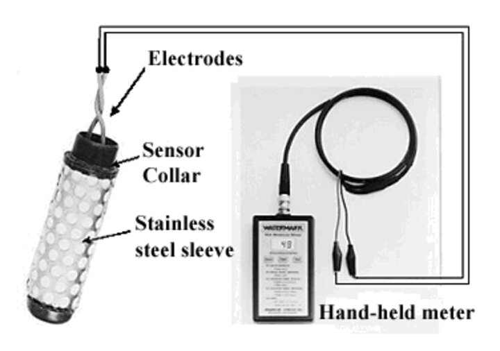
Watermark sensors are electrical resistance-based sensors that measure soil matric potential (SMP). Watermark Granular Matrix sensors are simple, economical, durable, and accurate tools to monitor soil water status. Water conditions inside the Watermark sensor change with corresponding variations in water conditions in the surrounding soil. These changes within the sensor are reflected by differences in electrical resistance between two electrodes imbedded in the sensor. Resistance between the electrodes decreases with increasing soil water.

Figure 1. Model 200SS Watermark® sensor with stainless steel sleeve and a hand-held meter. |
Sensors Improved with Sand
The new transmission material (sand) used in the sensor was designed to respond more quickly to soil wetting and drying cycles. Thus, the response time of the sensor to the changes in soil water status is faster than with the gypsum blocks. The Watermark sensor does not dissolve in the soil over time, which generally occurs with a gypsum block. The sensor has been proven to be accurate and provide a good indication of soil matric potential in a variety of soil types. The matric potential can be converted to soil water content and soil water availability or depletion per foot of soil layer can be determined. The sensors should be installed as early in the growing season as possible so crop roots can grow around them, allowing the sensors to provide a good representation of crop water uptake.
The soil matric potential values can be used to determine the irrigation trigger points for different soil types. Sensors can be installed every foot up to 3 or 4 feet deep in the soil profile to get a good representation of the soil water status in the crop root zone. The UNL Extension Circular, Watermark Granular Matrix Sensor to Measure Soil Matric Potential for Irrigation Management (EC783 PDF 530KB), provides detailed information on the operational characteristics of the Watermark sensors, installation, interpretation of the data, maintenance, and how they can be used for irrigation management. It also provides examples on how to calculate water depletion per foot from the Watermark readings.
The sensors can be read using a hand-held meter or a datalogger. The output from the sensors is in unit of kPa. Table 1, below presents the soil matric potential values as read from the Watermark sensors versus depletion per foot in the soil profile for eight different soil types in Nebraska. It also shows the suggested irrigation trigger points for different soil types. The trigger points were calculated by taking the crop growth stages into account. For example, to determine the irrigation trigger time for corn grown in a silt-loam soil, we suggest averaging readings from the top two sensors (at one and two feet). If this reading is 90-100 kPa before the tassel stage in corn, irrigation should be initiated.
After the tassel stage, we suggest averaging the top three sensors. If the average value from the three sensors is 90-100 kPa, irrigation should be initiated. This trigger point range is applicable for corn and soybeans. However, in silt-loam soils in the eastern, central, and south central Nebraska, we do not suggest irrigating soybeans before the R3 stage (early pod formation) because in an “average year” there is enough stored moisture and enough rainfall to create a soybean plant that can achieve high yields. Too much moisture can result in taller and leafier soybean plants that can lodge later and are more susceptible to disease. Delaying irrigations until the R3 stage encourages soybean plants to develop stronger, healthier root systems that grow deeper in search of moisture. (See the IANR News story, UNL Scientists Study Delaying Soybean Irrigation Until July.) For soybeans grown on a silt loam soil, the average of the top three sensors should be used to trigger irrigations.
The main reason for using the average of the top three sensors after tassel is that by this stage, the crop has a significant root density in the third foot and the root water uptake should be accounted for in determining the irrigation trigger point. By tassel, a significant portion of the water uptake for corn occurs in the third foot of soil.

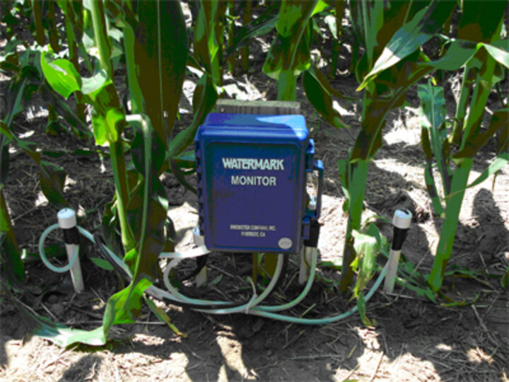
Figure 2. Watermark sensors installed between two healthy plants. The sensors are read using a Watermark datalogger. |
The sensors should be installed in the middle of two plants (Figure 2). Precautions should be taken to not disturb/damage the plant during the installation. Damaged crops will have a different soil water uptake rate and sensor readings will not be representative of the soil water status for normal healthy plants.
In Table 1, the suggested trigger points range from 90-100 kPa for silt-loam soils to 20-25 kPa for sandy soils due to differences in water holding capacity of different soil types. Silt-loam soils can hold as much as 2.2 inches of water per foot whereas sandy soils can hold about half of that. It’s important for growers to know the soil texture of their field(s) to determine which trigger point would be applicable.
In Table 1, trigger points were calculated, assuming there was no sensor malfunction. The trigger points were calculated based on the 35% depletion of the total soil water holding capacity per foot of soil layer. The sensor readings and trigger points should be checked against field crop appearance during the season. Prior to crop reproductive stages, the trigger point should be the average of readings in the top 2 feet of sensors. Once the crop reaches the reproductive stage, the trigger point should be the average of readings from the top 3 feet. However, for sandy soils, the average of the top 2 feet of sensors should be used at all times.
Using Watermark Sensors with an ETgages For Irrigation Management
The Watermark sensors and ETgages can be used together for irrigation management. The Watermark sensors should be used to determine when to initiate irrigation, based on the suggested trigger ranges in Table 1 for a given soil texture. After the first irrigation, the ETgages can be used to estimate actual crop water use since the last irrigation, using reference ET and crop coefficient approach, to replenish the crop water needs weekly. The Watermark sensors can be used again to determine the timing of the last irrigation. Between the first and the last irrigation, ETgages can be used alone to make irrigation management decisions. For more information on how to use ETgages for irrigation management, see the UNL Extension NebGuide, Using Modified Atmometers (ETgage) For Irrigation Management (G1579 PDF 974 KB).
Suat Irmak
Extension Water Resources Engineer
| Table 1. Depletion (in/ft) in available water versus soil matric potential and suggested range of irrigation trigger point for different soil textures. | ||||||||
| Soil type, depletion in inches per foot associated with a given soil matric potential value measured by the Watermark sensors, and available water holding capacity for different soil types | ||||||||
| Soil matric potential (kPa) | Silty clay loam topsoil, Silty clay subsoil (Sharpsburg) | Silt-loam topsoil, Clay loam subsoil (Keith) | Upland silt loam topsoil, Silty clay loam subsoil (Hastings, Crete, Holdrege) |
Bottom land |
Fine sandy loam | Sandy loam | Loamy sand (O’Neill) | Fine sand (Valentine) |
| 0 | 0.00 | 0.00 | 0.00 | 0.00 | 0.00 | 0.00 | 0.00 | 0.00 |
| 20 | 0.00 | 0.00 | 0.00 | 000 | 0.20 | 0.30 | 0.30 | 0.30 |
| 33 | 0.20 | 0.14 | 0.00 | 0.00 | 0.55 | 0.50 | 0.45 | 0.55 |
| 50 | 0.45 | 0.36 | 0.32 | 0.30 | 0.80 | 0.70 | 0.60 | 0.70 |
| 60 | 0.50 | 0.40 | 0.47 | 0.44 | 1.00 | 0.80 | 0.70 | 0.70 |
| 70 | 0.60 | 0.50 | 0.59 | 0.50 | 1.10 | 0.80 | 0.80 | 0.80 |
| 80 | 0.65 | 0.55 | 0.70 | 0.50 | 1.20 | 1.00 | 0.93 | 1.00 |
| 90 | 0.70 | 0.60 | 0.78 | 0.70 | 1.40 | 1.20 | 1.04 | N/A |
| 100 | 0.80 | 0.68 | 0.85 | 0.80 | 1.60 | 1.40 | 1.10 | N/A |
| 110 | 0.82 | 0.72 | 0.89 | 0.88 | N/A | N/A | N/A | N/A |
| 120 | 0.85 | 0.77 | 0.91 | 0.94 | N/A | N/A | N/A | N/A |
| 130 | 0.86 | 0.82 | 0.94 | 1.00 | N/A | N/A | N/A | N/A |
| 140 | 0.88 | 0.85 | 0.97 | 1.10 | N/A | N/A | N/A | N/A |
| 150 | 0.90 | 0.86 | 1.08 | 1.20 | N/A | N/A | N/A |
N/A |
| 200 | 1.00 | 0.95 | 1.20 | 1.30 | N/A | N/A | N/A | N/A |
| Water holding capacity (in/ft) | 1.8-2.0 | 1.8-2.0 | 2.20 | 2.00 | 1.80 | 1.40 | 1.10 | 1.00 |
| *Suggested range of irrigation trigger point (kPa) | 75-80 | 80-90 | 90-100 | 75-80 | 45-55 | 30-33 | 25-30 | 20-25 |
| (*)The trigger points were calculated, assuming 1) no sensor malfunction and 2) a 35% depletion of the total soil water holding capacity per foot of soil layer. The sensor readings and the trigger points should be verified/checked against the crop appearance during the season. The trigger point should be the average of the first 2 feet of sensors prior to crop reproductive stages and the top 3 feet once the crop reaches the reproductive stage. However, for sandy soils, the average of the top 2 feet of sensors should be used as a trigger point at all times. (N/A) Not available |
||||||||
