
Weather Recap: Below Normal GDDs plus Above Normal Moisture
As we move into the heart of the growing season, excessive moisture and cool conditions during May have led to planting delays, especially across the southern third of Nebraska and in the Panhandle. According to the Nebraska Rain Assessment Information Network (NERain), there was a report of measurable precipitation somewhere in Nebraska on 30 of the 31 days in the month.
The heaviest monthly total reported from the National Weather Service Cooperative Observation Network (NWS Coop) was 10.91 inches at the Lincoln Airport. Only about 50% of the NWS Coop sites report in real time, so it is entirely possible that this value will be exceeded as the data becomes available in digital format over the next month.
A similar analysis of the NERain locations found at least 26 locations that exceeded the monthly value at the Lincoln Airport, with the vast majority located in the Salt and Lower Big Blue watersheds. This roughly calculates out to just under 3% of the NERain locations exceeding the highest NWS Coop May value available at the moment.
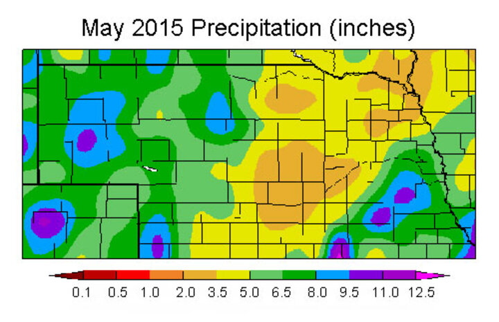
The distribution of May precipitation, as recorded by the NWS Coop network, appears in Figure 1. It shows the heaviest totals in the Panhandle and southeast Nebraska. Please note that the absence of 50% of the NWS Coop data results in an under-reported distribution of heavy precipitation from Fairbury northeast through Lincoln.
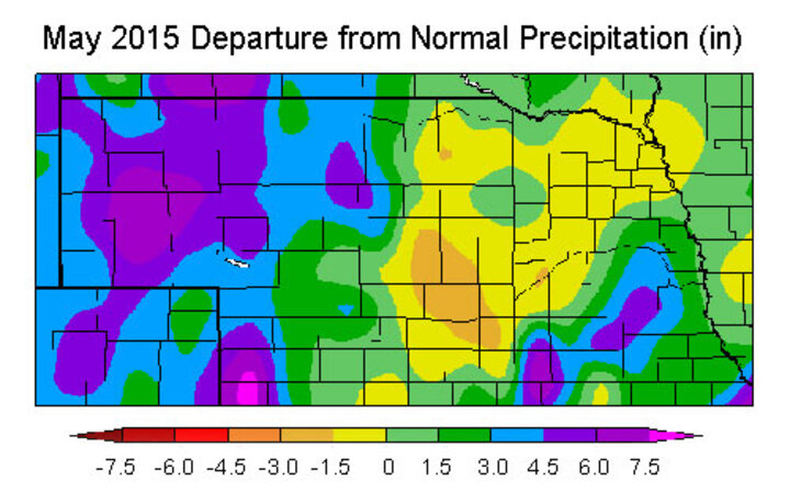
With such an aggressive weather pattern it may come as a surprise that a substantial portion of south central through northeast Nebraska actually recorded below normal precipitation during May. Figure 2 shows May precipitation deficits averaged just over 1.5 inches below normal in the central Platte River valley, with the remaining areas running just under normal to 1.50 inches below normal.
Much of the drought signature disappeared across Nebraska during the past 30 days, consistent with the trend across the entire central and southern Plains. Six years of intense drought across Texas and Oklahoma disappeared during the past four weeks. According to the U.S. Drought Monitor authors, 13.22% of U.S. land area was removed from drought during this period, which represents the second largest area decline over a four-week period in the Drought Monitor's history.
GDD Accumulations Down
Cool conditions in May resulted in below normal Growing Degree Day Unit accumulations, with the greatest deviation occurring across the northern third of the Panhandle and northwestern quarter of the Sandhills. Most stations are reporting deficit GDD accumulations for May of 80-120 units. The central third of the state had accumulated deficits 40-60 units below normal, while the southern third averaged 20-40 units below normal.
The bulk of the accumulated deficits occurred in late May as all reporting sites reported departures 50-70 units below normal. The most recent models project normal temperatures through the third week of June. This does not mean normal temperatures every day, but that the period should average close to normal and GDD deficits should not increase significantly.
Even though the weather models are indicating normal temperatures, they continue to project rain and thunderstorm development on 14 of the next 16 days. Additionally, these same model runs indicate that most of the precipitation events will initiate across western Kansas and Nebraska and move eastward overnight.
If the models verify, it may be very difficult to get enough drying between events to plant in optimal soil conditions over western and southern Nebraska. The ultimate question that remains is how many acres across the state are going to be placed in preventive planting status. Additionally, high flows and localized flooding that is currently ongoing along sections of the Platte, Blue, and Salt rivers will likely continue into the second half of June.
Reservoir Levels
Although the recent wet spell has created havoc for producers hoping to wrap up their spring planting, Lake McConaughy is reaping the benefits of such an aggressive precipitation pattern. The flows on the South Platte at Roscoe were running at 11,000 cubic feet per second (CFS) on June 1, while inflows into Lake McConaughy were reported at 6300 CFS. This translates to inflows four to five times greater than normal for Lake McConaughy and at least 10 times the normal flow rate for the South Platte.
The perpetual high flows on the South Platte are allowing Lake McConaughy regulators to hold back inflows, while using the excess South Platte flows to fill irrigation canals in preparation for summer allocations. Lake McConaughy has gained 56,000 acre/feet in the past week, 133,000 acre/feet in the past 30 days, and 367,000 acre/feet over the last year. At present inflow rates, Lake McConaughy will fill in less than four weeks.
With all of the moisture that has fallen across the central and southern Plains, there will be ample low level moisture available through evaporation and transpiration for transport northward. This type of pattern usually helps increase precipitation events developing across the northern half of the Plains. It also results in elevated dew points, which increases humidity levels and can limit maximum temperatures from consistently breaching the middle 90s.
Regional Forecast for this Summer
Weather models indicate a much drier pattern engulfing the southern Plains during the next two weeks which would increase surface evaporation and moisture transport into systems working eastward across the central Plains. These conditions will help recovery efforts from the excessive flooding, as well as provide good harvest weather for wheat acreage not lost to excessive moisture and disease.
What our models don't tell with a high degree of confidence is what type of weather conditions will envelope the primary grain region as we approach the critical pollination and grain fill periods of this growing season. The Climate Prediction Center (CPC) depicts an aggressively wet pattern for the western Corn Belt for the summer and fall across much of the central and southern Plains region. The highest precipitation probabilities for above normal moisture have been assigned to the western half of Nebraska.
Much of the CPC forecast is based on their forecast for El Nino conditions to continue through the summer and strengthen during the fall. There is a moderate to strong response across the southern and central Plains for above normal moisture during the late summer and fall period. This would be good news for grain fill, but would be detrimental to rapid harvest activity this fall across the western Corn Belt.
In addition to the current El Nino event, the eastern Pacific from the Gulf of Alaska south to the Baja Peninsula is experiencing above normal sea surface temperatures. This pattern is identical to last year at this time and helped promote strong tropical development and maintained their strength long enough that they could be pulled into the southwestern U.S.
The second hurricane of the season has already formed in the eastern Pacific and is projected to move northward across the Baja Peninsula. This indicates to me that hurricane activity is likely to enhance the monsoon season in the southwestern U.S. and will likely result in the remnants from several of these systems moving into western High Plains like last fall.
Finally, the Pacific Ocean remains warmer than normal while the Atlantic Basin continues to exhibit signs of cooler than normal conditions. With a warm Pacific and cool Atlantic, the risk of falling into the lowest 25% of the precipitation distribution falls from 1 in 4 to 1 in 7 for the western Corn Belt. The odds drop to 1 in 5 for the eastern Corn Belt, while increasing the odds of dry conditions across the southeastern U.S from 1 in 4 to 1 in 3.
Based upon all available information and statistics at my disposal, it appears that the western Corn Belt is favored to see above normal moisture for the remainder of the growing season. The eastern Corn Belt has much lower odds of experiencing above normal moisture, but the southeast has the greatest odds of seeing drought development.
Areas of the eastern U.S. coastal region and pockets of the southeast are presently reporting dryness issues that have shown signs of strengthening. If this continues, it will certainly verify my prediction. If dryness issues continue to develop, it would support strengthening the high pressure aloft over the southeast.
The western Corn Belt would benefit from being on the back side of the southeastern U.S. high pressure system. This would lead to a greater amount of Gulf of Mexico moisture being transported northward to interact with systems crossing the country and increase the likelihood of above normal precipitation this summer.
Al Dutcher
State Climatologist
