Nov. 3, 2015
The current El Nino event unfolding before our eyes has been well forecast for nearly six months and will likely lead to above normal temperatures this winter for the northern half of the continental U.S.
In July 2015 this El Nino was on pace to become the strongest event in recorded history. In the past 60 days, however, sea surface warming in the El Nino source region slowed down dramatically and it is now projected to be the second strongest in recorded history, dating back to 1950.
The US Climate Prediction Center (CPC) defines an official El Nino as five consecutive three-month periods averaging at least 0.5°C above normal. Weak events are defined as having a basin average 0.50 -1.0°C above normal, while moderate events are 1.0-1.5°C above normal. Strong events have at least one three-month period over 1.5°C. The following winters have met this criteria: 1957-58, 1965-66, 1972-73, 1982-83, 1987-88, and 1997-98.
Nebraska Outlook
Nebraska’s strongest weather correlation during El Nino patterns occurs from March through May and is not favorable during the spring calving season. The CPC indicates there is a strong tendency (65%-75% of the time) for the southern half of Nebraska to experience cold wet conditions in March and April, with above normal snowfall for south central and southwest Nebraska. In late April and early May it is not uncommon for the Panhandle and northwestern Sandhills to experience strong spring snowstorms 55%-60% of the time.
Please remember that past history can also be a guide to future scenarios. Statistical analysis of past El Nino events indicates that 80% of past moderate and strong events immediately reverted to La Nina conditions by the next fall. This El Nino is forecasted to end by June 2016. A La Nina would place the western Corn Belt under increased drought risk, especially during the second half of 2016.
Factors Leading to an El Nino
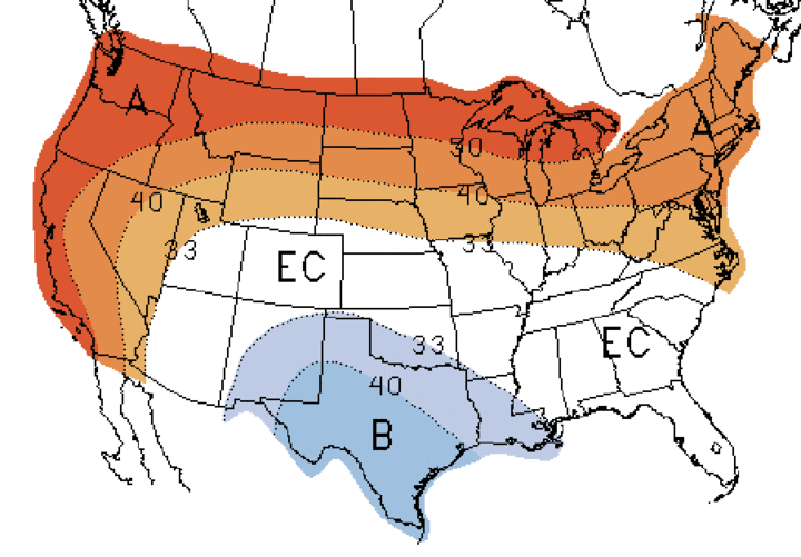
El Nino patterns lead to a weaker northern jet stream and an enhanced subtropical jet across North America. Because the northern jet is weaker, the influx of Arctic intrusions into the continental US is subdued compare to normal. The mean position of the northern jet results in an upper air trough over the Great Lakes and northeastern US, while an upper level ridge is positioned across the northern Rockies and northern Plains.
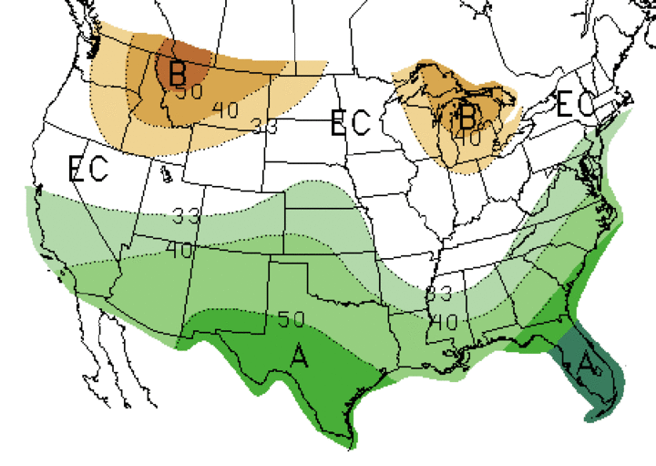
The primary storm track during El Nino winters is associated with the subtropical jet and this leads to systems moving from west to east across the southern third of the United States. This region experiences above normal precipitation and below normal temperatures during winter about 70% of the time. The stronger the event, the more likely that wet and cool conditions will dominate the southern states, including an increase in the probability that California will experience significant drought relief for California.
I have heard numerous comments about how California is missing out on precipitation from this El Nino and that it appears that this event will be a bust for drought relief. Climatology would suggest otherwise. On average, 90% of the moisture that falls across California occurs from November through May regardless of whether it is an El Nino pattern or not.
If the current short-term numerical weather models are correct in regard to increased West Coast storm activity, a significant uptick in moisture is anticipated for the southwest as we move through November. This projected uptick in moisture during the month of November is a predicated on the recent trend of upper air lows moving into the Gulf of Alaska and intensifying. This intensification is developing a mean upper air trough position that is digging into the central Pacific Ocean and supporting the movement of low pressure systems into northern and southern California.
If the sub-tropical jet begins to strengthen like it normally does during winter, it will add additional energy into low pressure troughs approaching the West Coast. This would be very favorable for increased precipitation chances for central and southern California. This is also the type of pattern necessary to develop an atmospheric river of moisture from the central Equatorial Pacific into North America.This “Pineapple Express” is the primary mode of moisture transport when long-lived (three to seven-days) precipitation events slam the West Coast.
Outlook for the Central Plains
Prior to the subtropical jet dominating North America’s winter weather, there is ample evidence that northern and southern stream upper air lows can cut off and spin over a region for several days before dissipating or being caught up in the next atmospheric wave moving eastward. This can lead to large fall or spring snowstorms and blizzards in the central and northern Plains region.
We have already experienced several cutoff lows this fall including, but not limited to, the August flood event in the southern Great Basin, the late September flood in the southeastern US, and the massive flooding in Texas during mid-October. Multiple cutoff lows have occurred during the last two months over the continental U.S. and several more would not be a surprise.
I am hopeful that we will see a continuation of recent storm activity into the Central Plains. Although most of the moisture hasn’t been heavy, we are getting regular precipitation. As long as ground temperatures remain above freezing, each of these events are adding moisture into the soil profile for next growing season. Ultimately, agricultural risks in 2016 will be partially predicated on whether our spring precipitation pattern is aggressive.
Al Dutcher
State Climatologist
