Brief Thaw for Valentine's Day
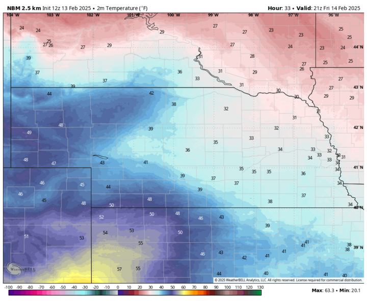
After a cold start to the day, temperatures will moderate this afternoon to the lower 20s in northeastern Nebraska, mid-20s in central and southeast Nebraska, and into the mid-30s in the Panhandle and far southwest Nebraska. Strong warm advection from the south and west continues tomorrow with temperatures getting well into the 40s in western Nebraska with high temperatures getting into the 30s elsewhere. Snow cover and clouds will limit warming somewhat, but most places should see some snow melt tomorrow. It also will be quite breezy in eastern Nebraska with sustained winds of 20-25 mph during the midday hours. In addition, there will be a chance for a mix of sleet and a very cold rain in southeast Nebraska tomorrow morning between 9 and noon. No major accumulations expected but be advised untreated surfaces could get a light glaze of ice for a short period. Blowing snow will also be an issue in open rural areas tomorrow morning. The nicest weather in the state will be in far southwest Nebraska where 50-55°F will be possible and winds will be lighter.
Snow Chances
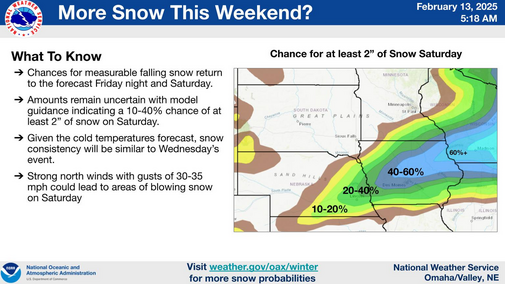
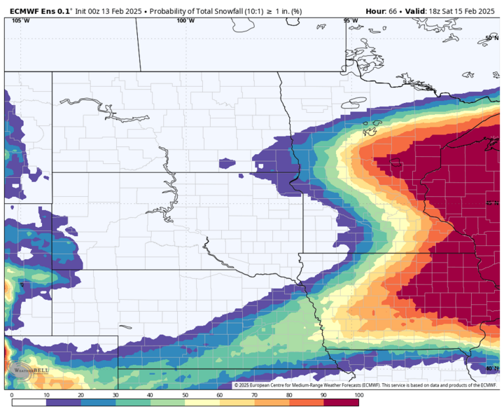
An arctic front will move through the state starting Friday evening and it does appear that there will be sufficient forcing along the front in southern and eastern sections of Nebraska to produce a short period of snow early on Saturday. There is not that great of agreement as to exactly where the heavier band of snow may be and precisely when. But my best estimate is that there will be snow along a southwest to northeast line from McCook toward Wayne later Friday evening and this will push east and southeast into eastern Nebraska by daybreak on Saturday. The ECMWF shows the best chance of getting 1-2 inches of snow will be in the I-80 corridor from York to Omaha. Higher snowfall amounts are more likely from eastern Iowa into Wisconsin.
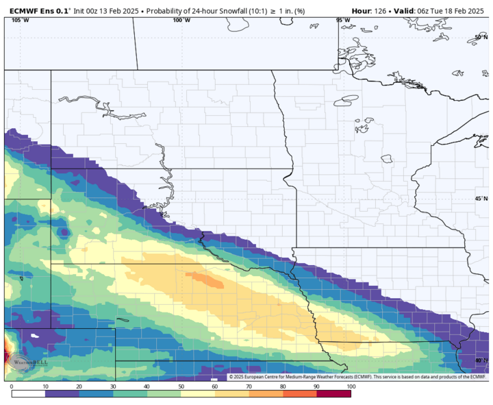
There should be a 36- to 48-hour break in snow chances and Sunday looks dry, but cold. More on the cold soon. An Alberta clipper system will move into the region on Monday and snow looks likely across most of the state. As of now, snow looks to move into the Panhandle and north-central section of the state late Sunday night and then move southeast into central and eastern sections of the state during the daytime hours. Chances for an inch or two look reasonable from Valentine to Columbus and Nebraska City. The amount of moisture associated with this system is not likely going to be sufficient enough to produce more than a few inches of powder, however. Wind speeds don't look terribly strong on Monday but there will be a breeze from the northeast during the snow.
Another upper-level shortwave will be moving from the southwestern U.S. into the Southern Plains on Tuesday and this will bring chances for 1-3 inches of snow across the southern Panhandle and the southwest part of the state. This storm will be worth watching though, as a more northeastward turn would increase the prospects of 2-4 inches of snow for a majority of the state on Tuesday into Wednesday. Given the position of the Arctic high, the heaviest snow likely will be to our south, where temperatures will be a bit more humane next week.
Polar Vortex Yoga = Record Cold Possible
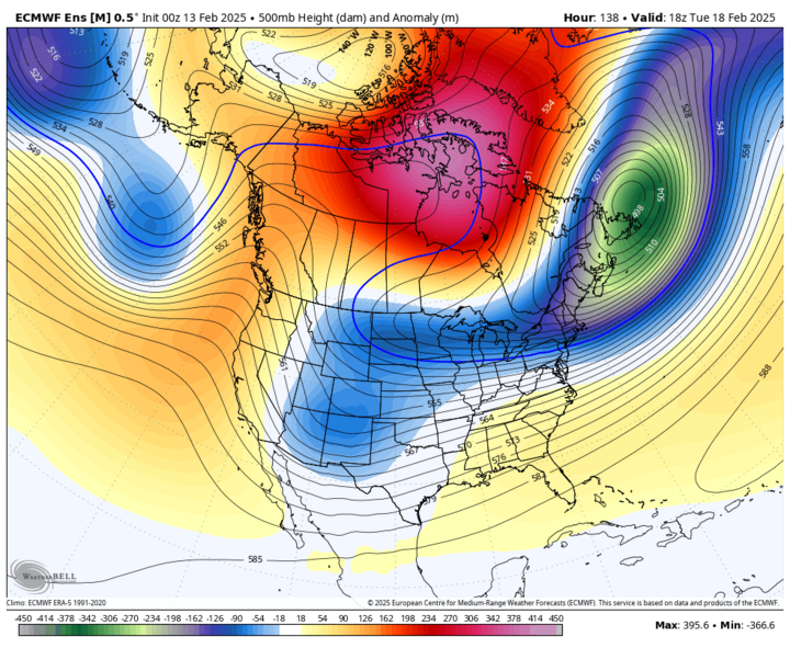
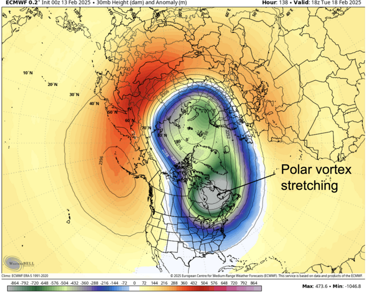
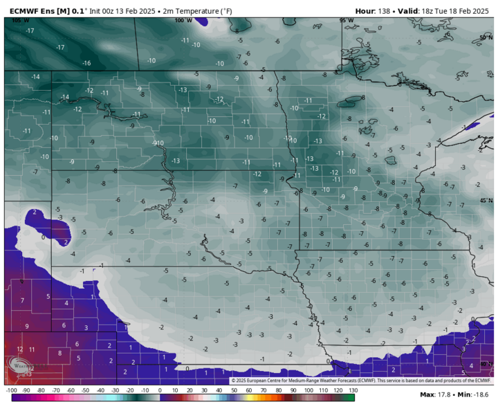
According to Dr. Judah Cohen of Janus Atmospheric and Environmental Research, next week will be the 10th polar vortex stretch this winter. It also looks to be the most potent. As a sidenote, changes (i.e., rapid warming) in the arctic region over the past few decades are linked to increasingly disruptive behavior in the polar vortex in the mid- and late winter. That is why we have still had some very cold temperatures in recent years and may continue to see brutal stretches of cold air in overall warming winters. The first shot of cold air this weekend will be followed by an even more potent arctic front early next week (with that Alberta clipper system). As the polar vortex stretches into the eastern half of the U.S., the coldest air will be just to the west of the center in the lower part of the atmosphere.
At the surface, models indicate the presence of a very strong surface high over eastern Montana that will slowly slide southeast into our area early next week. Translation: It will be very cold, perhaps record cold, over the state next week. This likely won't be quite as cold as mid-February 2021, but some of the recent model runs do suggest a reasonable chance of 1-2 days of highs struggling to get above 0°F next week, especially in north-central and eastern sections of the state on Tuesday. There is also a reasonable chance of temperatures dropping to 20-25 below on Wednesday and/or Thursday mornings. Wind chill values will remain colder than 20 below for a prolonged stretch, which is very problematic for calving. Bottom line: this has the potential to be a near record cold event next week. So be prepared.
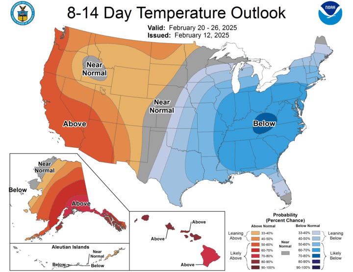
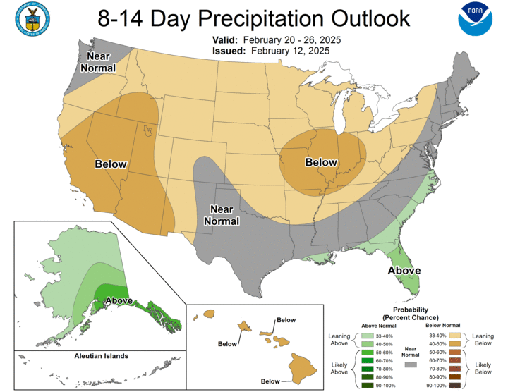
The good news is ridging looks to move back into the central U.S. next weekend, so a return to seasonal temperatures is expected by the week of Feb. 23. The CPC shows above average temperatures favored in the western U.S. in the eight- to 14-day period and precipitation likely being below average. Translation: Snow chances are less for the early portion of the week after next.