October 23, 2009
|
|
|
The Central Plains experienced record to near record cold the first 15 days of October, continuing the trend seen through much of the growing season. Temperatures the first half of the month have averaged 10 to 15°F below normal across Nebraska. Along with the cool temperatures, now rain and extended cloudy periods have contributed to significant harvest delays.
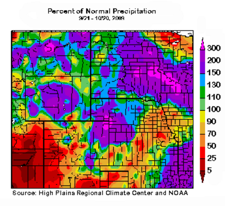
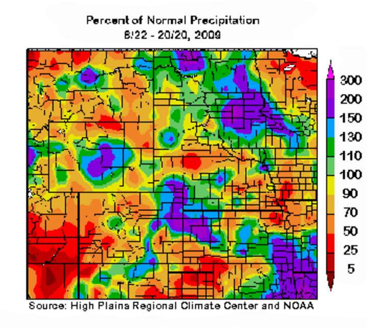
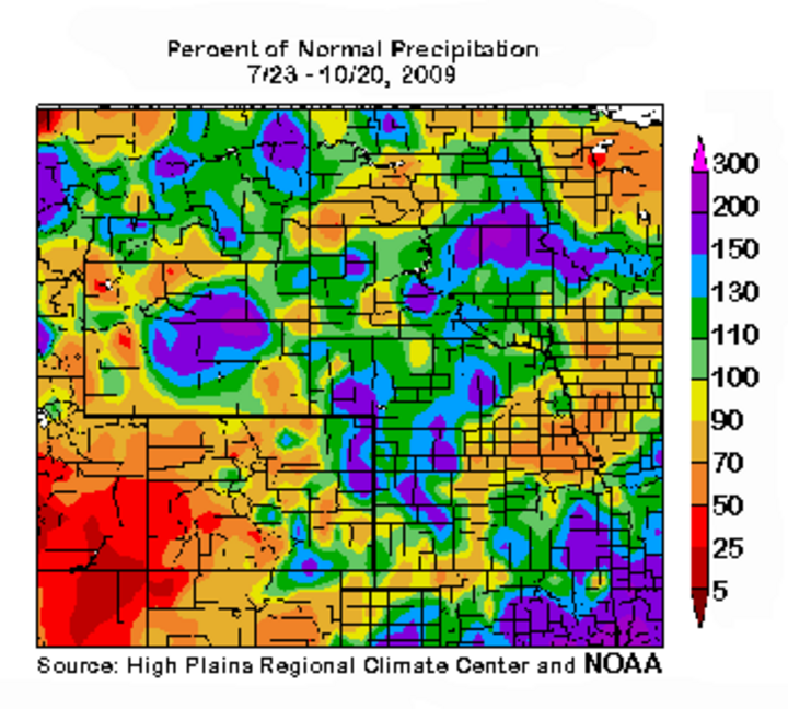
Even with the recent precipitation, portions of south central, southeast, and east central Nebraska continue to receive below normal moisture (not including the October 20-22 storm system). Looking at the past 30-, 60-, and 90-day percent of normal moisture plots reveals a distinct area of below normal moisture extending from the Texas Panhandle northeast into western Iowa. North, east, and west of this area show above normal moisture trends.
Soil moisture data from the High Plains Regional Climate Center’s reporting network indicate that much of the eastern fourth of the state had below normal soil moisture (top 4 feet) as of October 20. Levels were 1-3 inches below normal, but likely to improve to normal after this week’s storms which were projected to produce 1-2 inches of liquid equivalent moisture.
If the weather models are correct, abundant moisture and repeated storms in the next few weeks are likely to further delay harvest for much of the Corn Belt. Another system is poised to impact the central U.S. early next week, with a vigorous system taking aim on the region by the first of the month. Both of these systems have the potential to produce snowfall as the actual temperature pattern with the past few storms has been cooler than indicated by the models.
Current models do indicate dry periods October 29-31 and November 2-5; however, I am assigning a low probability to weather model depictions of an extended dry period during the first week of November.
Longer term, the Climate Prediction Center continues to push for above normal temperatures in every time scale out through late spring. Although the forecast resembles a typical El Nino forecast, they have consistently been too optimistic on temperatures for much of the year. Until the atmosphere reverses recent and past trends, I expect below normal temperatures to dominate much of the Corn Belt east and north of central Nebraska.
Eastern Nebraska. Statistical analysis of past first year El Nino events immediately after a La Nina event indicate below normal temperatures are common across eastern Nebraska through December. Temperatures begin to moderate in January, with above normal temperatures common in February. Precipitation trends indicate below normal moisture in November and March with above normal moisture in January.
Western Nebraska. The precipitation outlook for November through January is for normal to below normal moisture, with above normal levels common in February. Historical temperature data offers no real clue and actual conditions are highly dependent on the mean position of the northern jet stream. In years with a jet stream pattern similar to this fall, November through January temperatures tend to average below normal with significant temperature swings from much above normal to much below.
Allen Dutcher
State Climatologist
