July 13, 2007

|
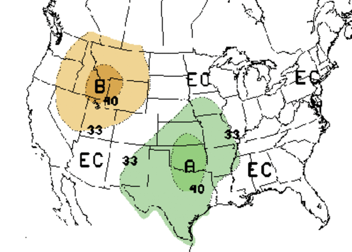
| Thirty-day precipitation outlook for July. Areas marked with an "A "indicate above normal precipitation while those marked with a "B" indicate below normal precipitation. "EC" indicates equal chances of either. |

|
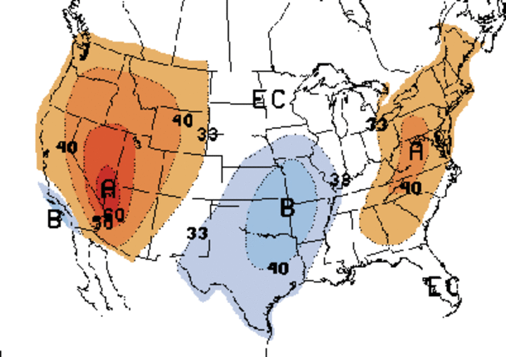
| Thirty-day temperature outlook for July. Areas marked with an "A" indicate above normal precipitation while those marked with a "B" indicate below normal precipitation. "EC" indicates equal chances of either. |
After an exceptionally wet January to May across the eastern two-thirds of Nebraska, drier than normal conditions have developed across much of the eastern fourth of the state. The first five months of the year were the wettest on record in Omaha, only to be followed by 0.24 inches of precipitation in June. This broke the previous June record of 0.25 inches set in 1933.
This six-week dry stretch has significantly depleted soil moisture reserves. The July 10 Drought Monitor indicates abnormally dry conditions for most areas east of Columbus, with a small area of moderate drought conditions in the immediate Omaha area. In addition, a combination of temperatures in the upper 90s to low 100s and below normal precipitation has resulted in an expansion of severe drought conditions across the northern half of the Panhandle.Occasional rainfall across the remainder of the state has kept conditions within the normal range, according to the latest Drought Monitor, but soil moisture levels are beginning to show signs of moderate depletion. Without continual precipitation events in the next six to eight weeks, it's likely that at least abnormally dry conditions will expand to the remainder of the state.
The current 30-day outlook for July indicates that southeast, east central and south central Nebraska are projected to receive above normal moisture, coupled with below normal temperatures. The rest of the state has equal chances of below normal, normal, or above normal temperatures and precipitation. The Panhandle is adjacent to a projected area of above normal temperatures and below normal precipitation.
Unfortunately, weather models through July 24 are not as optimistic as the 30-day forecasts for precipitation. Numerical models indicate the upper air ridge across the western United States will slowly build into the central plains over the next 10-day period. Therefore, moisture will be deflected north across the Dakotas and to the east of Nebraska. In addition, temperatures are projected to jump into the mid 90s to upper 90s as early as July 16 with 100° readings possible across the northwestern corner of the state from July 17 through July 21.
The monsoon season has officially begun in southern Arizona and the models indicate an expansion of moisture northward during the next two weeks. In fact forecasts for July 19-23 indicate above normal moisture for much of the Great Basin region, as well as Colorado and Wyoming. If the monsoon moisture makes its way into the central Rockies, current forecast models may be underplaying the precipitation potential for the central Plains in late July. Time will tell.
Al Dutcher
Extension State Climatologist
