The climate Prediction Center (CPC) has released forecasts for October and October through December.
Climate Prediction Center Forecasts
B indicates below average, A indicates above average, and EC indicates equal chances of below or above average.
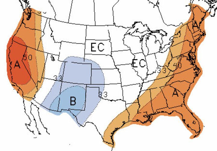
Figure 1. October Climate Prediction Center forecast for temperature.
 Figure 2. October Climate Prediction Center forecast for precipitation.
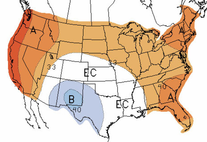
Figure 3. October-December Climate Prediction Center forecast for temperature.
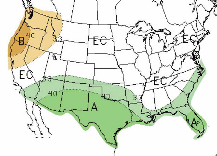
Figure 4. October-December Climate Prediction Center forecast for precipitation.
The 30-day forecast indicates below-normal temperatures from the southwestern US eastward through the southern High Plains and northeast through the southern Panhandle and southwestern corner of Nebraska. The remainder of Nebraska and the Corn Belt has equal chances of above normal, normal, or below normal temperatures.
The CPC indicates a wet forecast during October from western North Dakota southeastward through southern Iowa, then eastward through the northern half of Illinois. Also included are Minnesota, Wisconsin, and the western half of Michigan. The other core area of above normal precipitation includes the southwestern U.S. and southern Great Basin region. Nebraska is depicted as having equal chances for above normal, normal, or below normal temperatures.
The outlook for October through December indicates a tendency for below normal temperatures across eastern Arizona, New Mexico, and western Texas. Above normal temperatures are forecast for the West Coast states, the northern Rockies, the northern Plains, the central Corn Belt, and the eastern third of the US. In Nebraska, only the northeastern third of Nebraska is depicted as having above normal temperature tendencies during the next three months. The remainder of the state has equal chances for above normal, normal, or below normal temperatures.
Two broad areas of precipitation tendencies are indicated for the next three months. Below normal moisture is expected across the Pacific Northwest, while above normal precipitation is projected to fall from southern California eastward through Texas. This above normal precipitation area continues east of Texas, but is limited to the immediate Gulf Coast region and the coastal region of the southeastern U.S. northward through eastern North Carolina.
Weak El Nino conditions are expected to continue through the end of the year. This should allow for the subtropical jet to bring occasional storm activity from the Pacific into the southwestern U.S. and then move systems eastward into the southern Plains. This El Nino doesn't appear strong enough to block the movement of Arctic air into the continental U.S. for most of the fall and winter.
This would leave me to believe that weather conditions during the next five to six months will likely oscillate between polar plunges and warm El Nino conditions. Some forecasters may mention the term "El Nina" as they describe expectations for this upcoming winter. Essentially they are indicating that they expect large temperature swings which at times will resemble El Nino conditions and at other times will resemble La Nina conditions.
Temperatures regularly switched from above normal to below normal every two to three weeks during most of this past growing season. This is a prime example of the "El Nina" that forecasters are describing. The more difficult question relates to whether Arctic air intrusions will be accompanied by slugs of moisture moving out of the southwestern U.S. and interacting with polar air plunges.
Tropical Systems Could Hinder Harvest
Over the last three weeks three tropical systems have traveled up the northern coast of western Mexico and into the Baja peninsula. These slugs of moisture have continued northward into the southwestern U.S. and eventually east or north depending on the position of the northern jet stream.
Hurricane Norbert brought significant flooding into Arizona and then the moisture was drawn northward into the central Rockies by a northern jet stream trough sliding south out of Canada. This resulted in a heavy band of moisture that fell across Nebraska and points eastward during Husker Harvest Days (Sept. 9-11).
Hurricane Odile followed a similar path as it rode up the Baja peninsula, but then turned eastward toward the southern Plains and an upper air ridge over the northern Rockies turned the remnants eastward toward Texas.
Hurricane formation in the eastern Pacific will likely remain active for the next six weeks and additional systems are expected to move up into Baja region. Therefore, periods of heavy precipitation are likely as moisture from these systems moves east or north, depending on the position of the northern jet. East-moving systems would target the southern Plains, north-moving systems would target the central Plains, including Nebraska.
If one of these tropical systems were to move inland as a significant polar push was moving into the northern Rockies, heavy rain and/or snow would be expected over several days and could cause significant harvest delays across the western Corn Belt. The bottom line is that these tropical systems have the potential to cause additional harvest delays if the moisture is drawn northward.
Al Dutcher
Extension State Climatologist
