Friday Night Lights
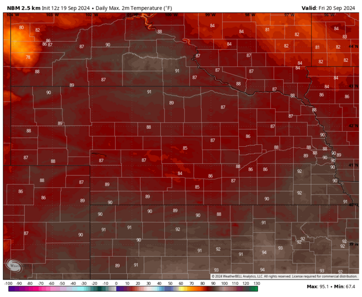
It will be unseasonably warm on Friday with highs in the upper 80s to lower 90s in much of Nebraska, with sunshine prevalent. The National Blend of Models (NBM) suggests a high of 92 in Lincoln, which is 15°F above the long-term average for Sept. 20. Keep the koozies handy for tailgating. It will be an unseasonably warm evening for the Nebraska football game, with kickoff temperatures likely around 86°F. But with a modest breeze from the southeast and the sun setting in the first quarter, it should be a nice evening in Memorial Stadium for the game overall. At least in the first half.
A warm front will be moving to Highway 136 corridor by halftime and there is going to be a chance that elevated storms develop out of ahead it. Translation: There is a slight chance thunderstorms impact the game in the fourth quarter. A strong running game and minimal yellow laundry thrown at the offensive line would help ensure the game ends before Mother Nature interrupts it. But this is nowhere close to a guarantee that the game will get interrupted, as was the case in the first game in 2018. Best chance of thunderstorms in eastern Nebraska will be after midnight on Friday. Our forecast for the game itself:
Eric's prediction: Nebraska 28, Illinois 16
Camille's prediction: Nebraska 26, Illinois 18
I Wish It Would Rain Down
With all due respect to Phil Collins, we NEED it to rain down in Nebraska and preferably to rain down for a good while. Thankfully, there is a good chance that will happen for most of the state.
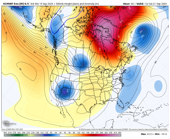
A slow-moving upper-level low that will be headed northeast from the Four Corners region will be the main catalyst for much-needed rainfall for most of the state. Strong isentropic lift will help widespread precipitation develop in Kansas on Saturday afternoon, Sept. 21 and then move north into the state Saturday evening. Several hours of light to moderate rainfall are likely on Saturday night for all but the northwest sections of the state, where precipitation is likely to be considerably less. Pockets of thunderstorms with more intense rainfall are possible along and south of I-80 but flash flooding does not look to be a major risk. Rain should continue into Sunday morning with showers and a few rumbles of thunder likely along and south of I-80 (east of Kearney) through Sunday evening, Sept. 22.
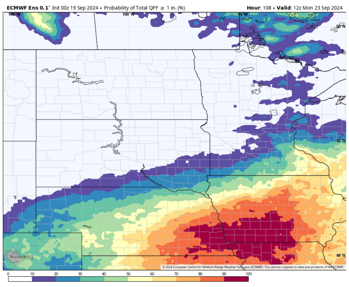
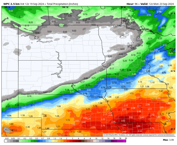
An inch of precipitation is very likely across all of southeast Nebraska and likely over most of northeastern and central Nebraska. Chances of an inch are lower in the west-central and southern Panhandle sections of the state and highly unlikely in the northwestern corner, where drought conditions are most acute. The WPC outlook shows most of the area along and south of the Platte River in central and eastern sections Nebraska may pick up two to three inches total. It is possible those amounts may be a bit optimistic, but it will still be the best rain most places have seen since early July.
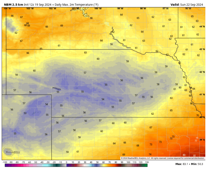
Temperatures will be cooler on Saturday statewide with the clouds cover and precipitation moving in and will be a bit brisk on Sunday in most of western and central Nebraska, with highs likely not getting out of the mid-50s in Broken Bow, Ord, Holdrege, Grand Island and Kearney. Southeast Nebraska should still manage to get into the lower 60s and the northwest corner is likely to be in the mid-60s. Perfect (insert your favorite fall beverage) weather.
Pleasant Work Week
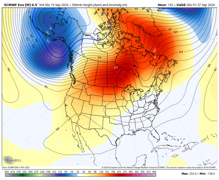
The storm system should exit the region by Monday morning, Sept. 23, though temperatures are likely to be seasonally cool with highs in the low 70s in the Panhandle and 65-70 everywhere else. Upper-level ridging will again be dominant to our north for the remainder of the week, which will keep skies mostly clear Monday through Thursday, Sept. 26, and temperatures around seasonal norms (70s) for much of the week. Exception to the rule will be the northwestern Sandhills and northern Panhandle where above average temperatures in the 80s are likely the second half of next week.
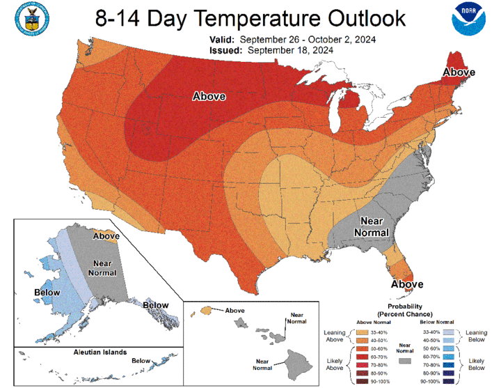
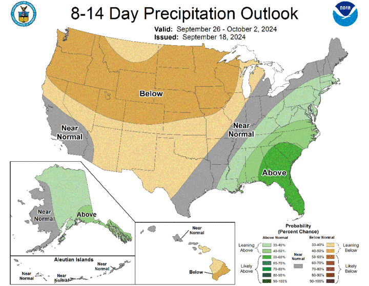
There may be a weak disturbance traversing the state later in the week, which would lead to the potential for more cloud cover and a slight chance of showers. But the remainder of the week after Sunday night is more likely than not to be dry for everyone. A peak at the CPC's eight- to 14-day outlooks shows the drier, warmer pattern at the end of next week likely will continue into the first part of October. This should allow for an extended harvest window and improved surface moisture would greatly reduce the wildfire risk going into October.
Drought Update
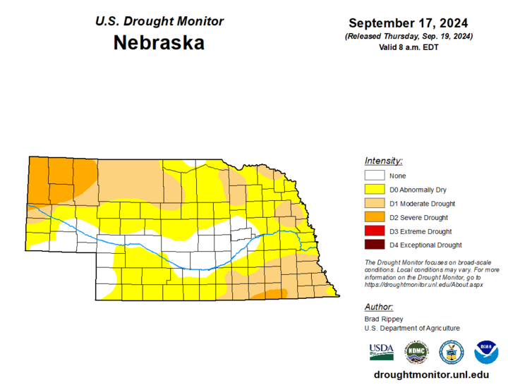
The reason we need the rain so bad is we are on the verge of seeing a majority of the state go into drought before we head into winter. Once we get into winter, the odds of coming out of a deeper drought are rather slim. A look at the latest U.S. Drought Monitor shows that drought now encompasses a majority of the southeastern quadrant of the state, including all of the city of Lincoln. Drought also expanded in northeastern Nebraska, especially in Burt, Cuming, Cedar, and Dixon counties, and also expanded into more of the Sandhills. More of the northern Panhandle is now in severe drought.
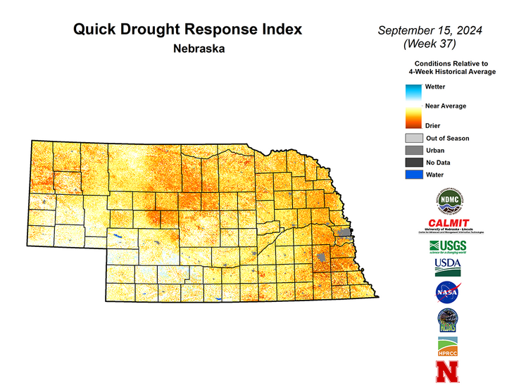
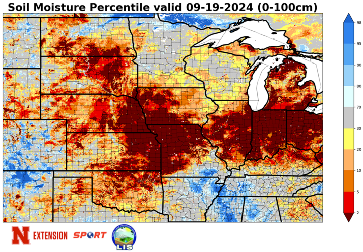
QuickDRI also shows a majority of the state is quite dry and likely helps confirm emerging stress to pastures and where late-planted crops have been experiencing stress. A look at the national QuickDRI map shows dryness and some stress across a lot of the U.S., including in much of the Corn Belt. Makes me wonder if some of the earlier projections of corn and soybean yield might have been a little too optimistic.
If the rain projected this weekend ends up being much less than expected, then much of the area currently in yellow on the U.S. Drought Monitor for abnormal dryness (D0) will be in drought by the middle of October, if not sooner. Areas currently in drought are more likely to see additional degradation without this precipitation. Based on the current forecast, the area in the state most likely to see additional degradation in the next month will be the northwestern Panhandle.
More importantly, from an agricultural impact standpoint, this rainfall will be critical for the 2025 winter wheat crop to get off to a good start. Same for cover crops that will be in the ground this winter.
Temperature and Precipitation Summaries
This document contains the maximum/minimum temperature, average temperature, number of days with maximum temperatures ≥95°F, minimum temperatures ≥70°F, degree days, and total precipitation for each Mesonet station over the period from Sept. 8-14.
Below are the temperature and precipitation extremes around the state over the past week:
- Maximum Daily High Temperature: 98°F, Agate 3 E
- Minimum Daily High Temperature: 78°F, Bushnell 15 S
- Minimum Daily Low Temperature: 33°F, Harrison 20 SSE
- Maximum Daily Low Temperature: 71°F, Lincoln Airport
- Maximum Weekly Precipitation: 2.08 inches, Spalding 7.5 SSW
- Minimum Weekly Precipitation: 0.00 inches, multiple locations
