Best Rain Since August
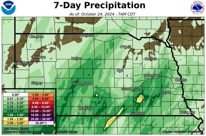
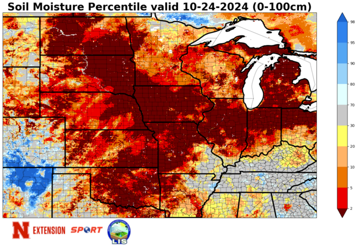
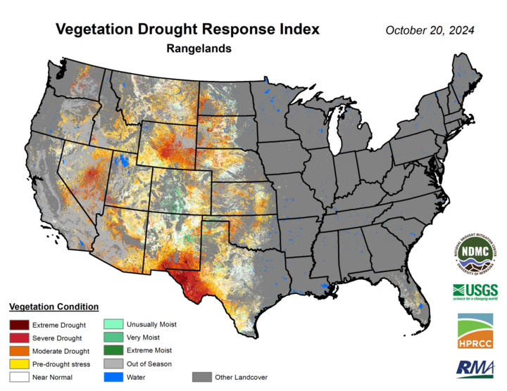
The long streak of no precipitation in the state ended last Thursday evening when light showers occurred along a cold front that entered the Panhandle. These showers did not amount to much but a few places in Dawes County picked up around a tenth of an inch. Then on Friday night into Saturday morning, the front was a focal point for more robust precipitation across portions of southwest and west-central Nebraska, with 1.00-1.25-inch being common in an area from Dundy County and to the west and northwest of North Platte. As the upper level low finally ejected out into the Central Plains on Monday morning, showers and thunderstorms developed in northern Kansas and then moved to the northeast into south-central and eastern sections of Nebraska. This brought the best rain most places in these areas of the state had seen in nearly two months, perhaps longer in some cases. A broad section received over 0.50-inch and totals over an inch were common in Franklin, eastern Adams and Clay counties. This did not lead to any improvements on the U.S. Drought Monitor but the moisture was very welcome nonetheless. Soil moisture percentiles did improve a bit in areas that received moisture with the biggest improvements noted in Clay and Franklin counties.

But Not Everyone Got Rain
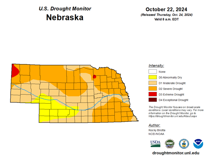
Mother Nature was generous over the last week to much of the southern half of Nebraska but the northeastern and northwestern parts of the state mostly got the shaft once again. Some places in western Wayne County still have not received measurable precipitation since August and parts of Box Butte County in the Panhandle have not had more than 0.02-inch in a day in over two months. Areas that did not receive any meaningful moisture over the last week generally saw additional degradation on the U.S. Drought Monitor this week.
The latest map shows further degradation in the northern part of the state with increased areal coverage of severe drought (D2) in northeast and north-central Nebraska and additional expansion of extreme drought (D3) in the northwest Panhandle. A small area of extreme drought was also introduced to northwest Antelope County and small portions of Holt and Knox counties. Northern portions of Cedar and Dixon counties are getting very close to that threshold as well.
Another Dry Frontal Passage
A cold front is currently traveling through the state and will bring cooler temperatures and some cloud cover. A brief shower may occur across the northern third of the state this afternoon but most of the precipitation will fall to our east in eastern Iowa and Illinois, where they also are in real need of moisture. Far southeast Nebraska may be on the western extent of the precipitation. High temperatures will be seasonal in the low to mid-60s statewide tomorrow and will remain seasonal in central and eastern sections of the state on Saturday. Sub-freezing temperatures are likely in the western half of the state tomorrow morning and will be possible statewide on Saturday morning. Temperatures will rebound into the 70s in the Panhandle on Saturday and will be above average statewide on Sunday.
Football Forecast
The weather looks ideal for football in Columbus, Ohio on Saturday. Temperatures should get into the low 60s with plenty of sunshine and a light breeze from the north. Unfortunately, our predictions for the game are not ideal unless you are a Buckeye fan. We both expect Nebraska to lose soundly. Both of our projections would technically cover the current spread. On the plus side, Nebraska volleyball swept Ohio State last weekend and we're a volleyball school now, right?
Camille's prediction: Ohio State 40 Nebraska 17
Eric's prediction: Ohio State 38 Nebraska 14
Record Warmth East, Breezy and Chances for Moisture
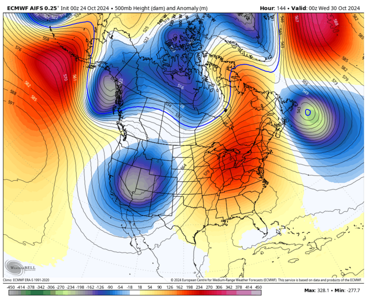
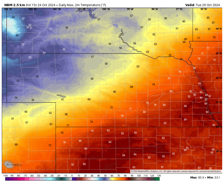
By early next week mid-and upper-level ridging will be anchored over the region as a sharp trough moves into the western U.S. Temperatures will easily exceed 75°F everywhere on Monday and temperatures in the low to mid-80s will be likely in the southeastern quadrant of the state. Records may fall in Omaha and Lincoln. It also will be fairly windy on Monday in the eastern half of the state with sustained winds of 20-25 mph possible on Monday afternoon. Fire danger will be elevated but humidity levels should be high enough in the eastern half of the state to keep it from getting into the critical category. By Tuesday, a cold front will be moving through the state and it is looking possible that showers will develop behind the front in the western half of the state Tuesday night into Wednesday morning. Ahead of the front it will be another breezy, abnormally warm day in the upper 70s to mid-80s. Behind it expect highs to range from the mid-40s to the lower 50s.
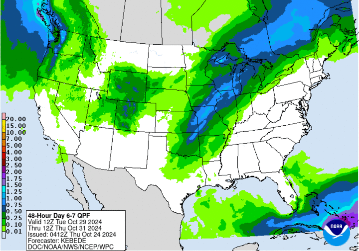
The front should clear the state by early Wednesday afternoon and an additional area of showers is likely to develop from Kansas into Wisconsin. Exact placement of the surface low is still a bit in question but right now, the heaviest precipitation currently looks to fall across far southeast Nebraska and points east. But everywhere east of Highway 81 has a shot at picking up a quarter inch on Wednesday. Amounts of a half inch to an inch will be possible in Richardson County. Temperatures may get into the 70s in the southeast corner of the state if the front is a bit slower. Highs likely will be in the 50s in eastern Nebraska behind the front and most of the western half of the state is likely to see highs in the 40s on Wednesday.
Seasonal Halloween
Precipitation should be out of the state by Thursday morning with sunshine in the west and clouds giving way to sun in the east. Afternoon high temperatures should be seasonal in the mid-50s to around 60, falling to the lower 50s during the early evening hours. Won't be the warmest Halloween but will be warmer than last year. Certainly won't be anything like Halloween of 1991 when a foot of snow fell in parts of central and northeast Nebraska and ice caused problems in the southeast part of the state.
More Rain Possible Next Weekend
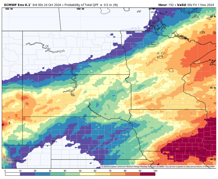
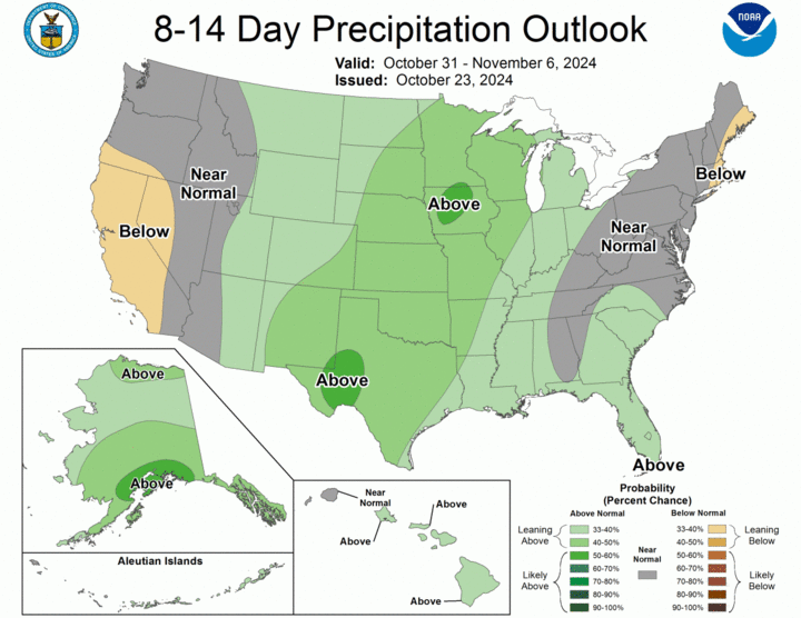
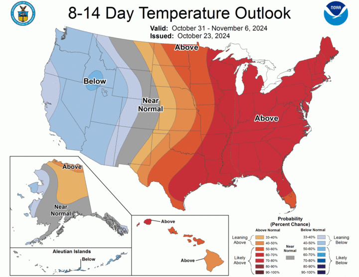
Models do show some hints of another system moving into the central U.S., which could give southern and eastern sections of the state a chance at moisture. But there is not a lot of agreement in the models on where the heavier bands of precipitation may be and the ECMWF AI has not bullish on moisture for Nebraska. Temperatures look to be seasonally cool to end next week with highs in the upper 40s to mid-50s. A look a little deeper into the crystal ball shows ridging returning to the region the week of Election Day, which would favor dry conditions and temperatures possibly getting well into the 70s at times.
November Outlook
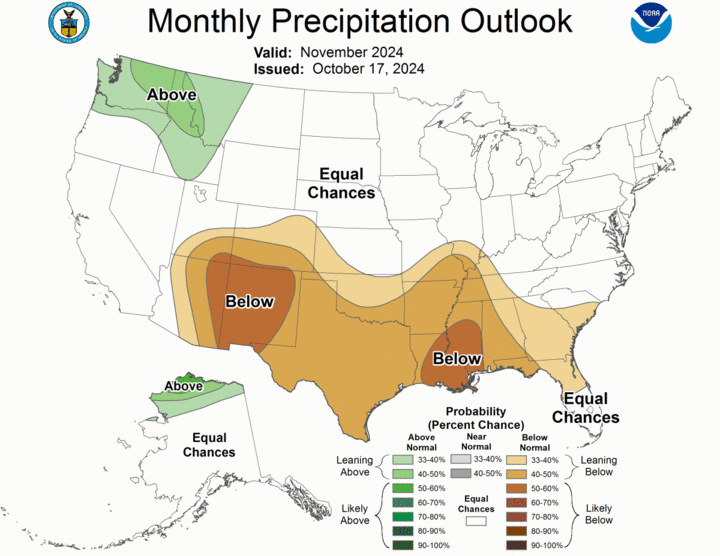
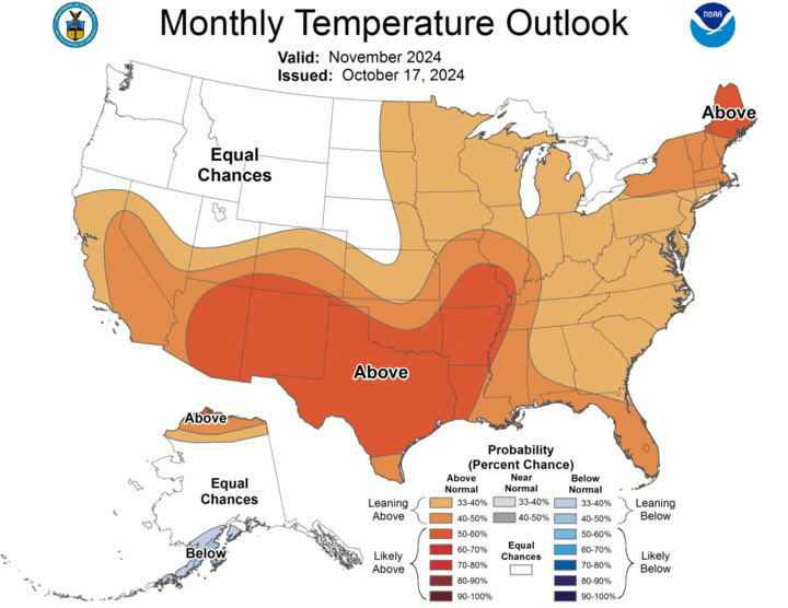
The CPC's outlook for November calls for near-average precipitation statewide and warm temperatures favored in eastern Nebraska. Near average temperatures favored elsewhere. The ECWMF weeklies are interesting. The expected temperature and precipitation anomalies for the month would suggest troughs getting deeper into the western U.S. more consistently with ridging being dominant in the eastern U.S. This is reflected by cooler than average temperatures being more prominent in the western third of the U.S., including the Nebraska Panhandle. Such a pattern could favor more regular chances of precipitation for much of the central U.S., including central and eastern sections of Nebraska. A wet November doesn't necessarily equate to drought eradication but it could mean going into winter with some moisture. No guarantee this solution plays out but it is a believable solution.
Temperature and Precipitation Roundup
This document contains the maximum/minimum temperature, average temperature, number of days with maximum temperatures ≥95°F, minimum temperatures ≥70°F, degree days, and total precipitation for each Mesonet station over the period from Oct. 13-19. Soon we will be transitioning to winter statistics.
Below are the temperature and precipitation extremes around the state over the past week:
- Maximum Daily High Temperature: 87°F, Verdel 6 SSE
- Minimum Daily High Temperature: 41°F, Bushnell 15 S
- Minimum Daily Low Temperature: 18°F, Superior
- Maximum Daily Low Temperature: 59°F, Hebron
- Maximum Weekly Precipitation: 2.05 inches, Fairfield 2.8 NE
- Minimum Weekly Precipitation: 0.00 inches, multiple locations
