Introduction
Nebraskans in the eastern part of the state have recently experienced good rainfall during April and early May. This was a much-needed relief, especially considering the dry winter with minimal rainfall/snowfall and the dry 2023 growing season. While rainfall is always welcomed, assessing whether the received rainfall was sufficient to recharge soil moisture to adequate levels is not an easy task. This information plays a crucial role in planning the first irrigation event of the season and estimating the duration until water deficit begins to affect crops in dryland fields.
This article covers some key aspects of soil-water relations and how the recent rainfall events affect available soil moisture.
Basics of Soil Water Holding Capacity
Different soil types have varying capacities for holding water, known as soil water holding capacity. In simple terms, soil water holding capacity refers to the amount of water available in the soil for plants to utilize assuming the soil is at field capacity.
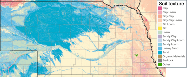
In Nebraska, soil water holding capacity can range from 1.0 to 2.5 inches of water per foot of soil depth. Table 1 illustrates these values for different soil types in Nebraska. For instance, sandy loam soils typically offer 1.4 inches of water per foot of soil depth, indicating that plants can access up to 1.4 inches of water from each foot of soil. Figure 1 shows surface soil texture for Nebraska.
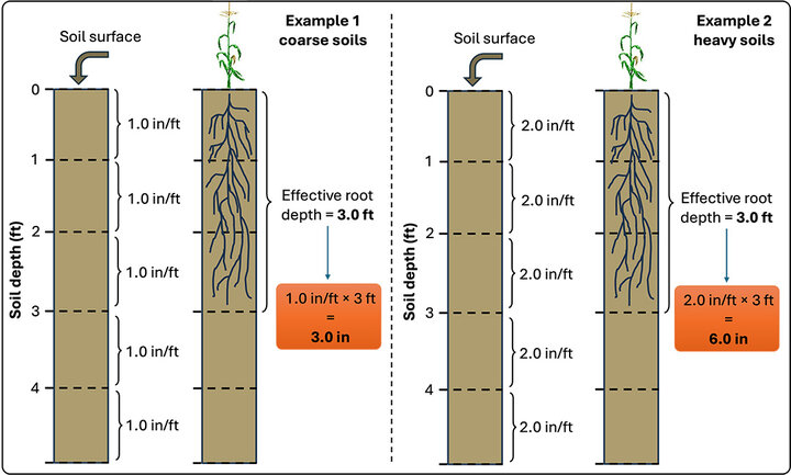
As crops progress through the growing season, their root systems extend deeper into the soil, allowing them to access more available soil moisture. By mid-season, the root system usually reaches its maximum depth, which can be used to estimate the total available soil moisture for the crops.
Figure 2 provides an example of the total available soil moisture for corn plants, assuming an effective root system depth of three feet for two soil types with differing soil water holding capacities. For soils with a water holding capacity of 1.0 inch per foot, this translates to 3.0 inches of available soil moisture for the plants. In contrast, soils with a capacity of 2.0 inches per foot can supply a total of 6.0 inches of available soil moisture to the plants.
| Soil Type | Available Soil Water (in/foot) |
|---|---|
| Fine Sand | 1.0 |
| Loamy Sand | 1.1 |
| Sandy Loam | 1.4 |
| Silty Clay or Clay | 1.6 |
| Fine Sandy Loam, Silty Clay Loam, or Clay Loam | 1.8 |
| Sandy Clay Loam | 2.0 |
| Loam, Very Fine Sandy Loam, or Silt Loam topsoil with Silty Clay Loam or Silty Clay Subsoils | 2.0 |
| Loam, Very Fine Sandy Loam, or Silt Loam topsoil with medium textured subsoils | 2.5 |
Rainfall and Available Soil Moisture
The actual available soil moisture represents the amount of water present in the soil for plants at any given moment. At the beginning of the planting season, this availability depends on various factors such as weather conditions from the previous growing season, irrigation practices, and the accumulation of rainfall and snowfall during the off-season.
In regions like east-central Nebraska, dryland corn/soybean fields will show extremely low levels of available soil moisture by the end of the growing season, often a consequence of prolonged drought conditions over the past two years. In contrast, irrigated fields tend to retain higher levels of available soil moisture due to controlled water application.
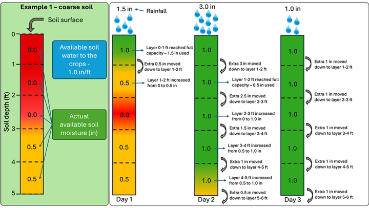
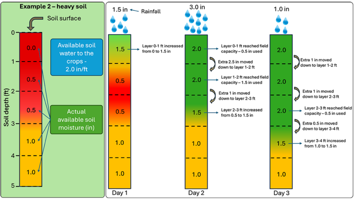
Understanding the starting point of available soil moisture is crucial for assessing how rainfall will impact it. Figures 3 and 4 provide hypothetical examples for two different soil types with initially low levels of available soil moisture. These initial levels were assumed based on the drought conditions of the preceding two years, which persisted due to limited rainfall and snowfall during the fall and winter seasons of 2022 and 2023.
In the example of coarse soils (Figure 3), the available soil moisture for soil layers at depths of 0-1, 1-2, and 2-3 feet is at 0 inches, while layers at depths of 3-4 and 4-5 feet have 0.5-inch of available moisture. For heavy soils (Figure 4), the available moisture for layers at depths of 0-1 feet is at 0 inches, layers at depths of 1-2 and 2-3 feet have 0.5-inch, and layers at depths of 3-4 and 4-5 feet have 1.0 inch. A rainfall event occurred over three consecutive days, with amounts of 1.5 inches on Day 1, 3.0 inches on Day 2, and 1.0 inch on Day 3.
For the coarse soils example (Figure 3), the 1.5-inch rainfall on Day 1 exceeded the soil water holding capacity for the top layer (1 inch/foot), thus fully recharging the available soil moisture to 1.0 inch. Any excess water beyond the soil's capacity moved downward to the next layer, resulting in the available moisture being replenished to 0.5-inch at the 1-2 foot depth. The subsequent 3.0-inch rainfall on Day 2 fully recharged all layers to their capacity down to 5 feet, with an additional 0.5-inch moving downward. The 1.0-inch rainfall on Day 3 was surplus, as all layers were already at full capacity.
In the heavy soils example (Figure 4), the 1.5-inch rainfall on Day 1 partially replenished the available soil moisture, leaving the top layer at 1.5 inches, which was 0.5-inch short of full capacity. The 3.0-inch rainfall on Day 2 fully recharged the top two layers but left the 2-3 foot layer 0.5-inch short of full capacity. The 1.0-inch rainfall on Day 3 was insufficient to fully recharge all layers to their capacity.
An important factor to measure effective rainfall infiltration are the intensity of rainfall (inch/hour) and the soil's infiltration rate (inch/hour). Intense rainfall can surpass the soil's infiltration rate, leading to runoff. Conversely, slower rainfall rates are less likely to cause runoff, allowing most of the rainfall to infiltrate into the soil profile.
Soil conservation practices play a significant role in mitigating runoff. For instance, a tilled field situated on hilly terrain is more susceptible to runoff compared to fields with cover crops or other soil conservation measures in place like no-till.
A final factor is the topsoil evaporation due to the rising air and soil temperatures. It is expected that the topsoil (0-6 inches) show a decrease in available soil moisture between irrigation events, so that should also be accounted for when estimating the water amount that entered the soil at each rainfall event.
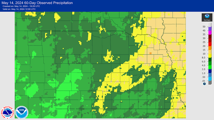
Total Rainfall in Nebraska During Spring
Many areas in Nebraska have experienced numerous rainfall events since mid-March 2024. Over the past 60 days, most regions of the state have accumulated rainfall ranging from 4 to 10 inches (Figure 5). Referring back to Figures 2 and 3, which shows changes in available soil moisture with a hypothetical accumulated rainfall of 5.5 inches, it is highly probable that the soil depths of 0-5 feet in non-cropped lands across Nebraska have been replenished to or close to full capacity.
Good rainfall over the past 60 days should have resulted in soil moisture levels that will benefit the early stage development of soybeans and corn in our state.
For more information, please contact your local extension educator.
