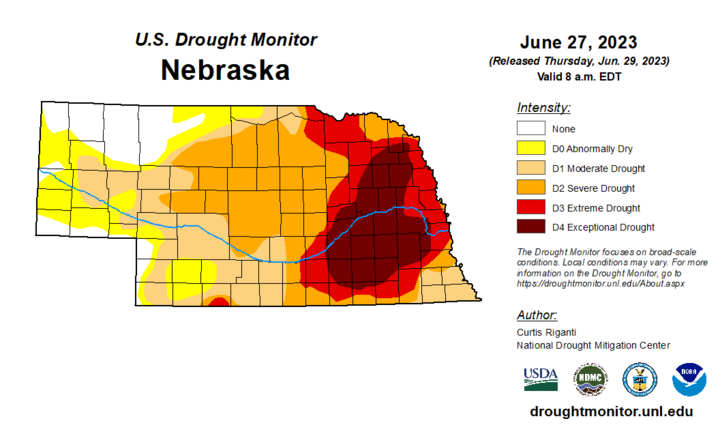
Drought Update
As has been the case for much of the growing season, there is good news and bad news to report about regarding drought. The good news is that much of northwestern Nebraska is now free of both drought and abnormal dryness after significant precipitation fell there earlier this week. The bad news is that there was continued expansion of extreme (D3) and exceptional (D4) drought in eastern Nebraska, with exceptional drought now creeping into the western side of the Omaha metro area for the first time on record.
Precipitation Update
A quick look at precipitation deficits that have accumulated over the past 365 days (through June 28) reveals the following approximate deficits in the eastern half of Nebraska:
- Kearney, -4.94 inches
- Newcastle, -5.70 inches
- Hastings, -9.54 inches
- Falls City, -10.40 inches
- Grand Island, -12.40 inches
- Norfolk, -12.64 inches
- Plattsmouth, -13.73 inches
- Nebraska City, 14.34 inches
- O’Neill, -14.94 inches
- Columbus, -15.07 inches
- West Point 5.0 NW, -15.74
- Seward, -16.00 inches
- York, -16.12 inches
- Lincoln, -16.82 inches
- Beatrice, -17.53 inches
- Osceola 7.1 W, -19.50 inches
- Lincoln 8 NE, -19.63 inches
- Omaha 10 WSW, -20.30 inches
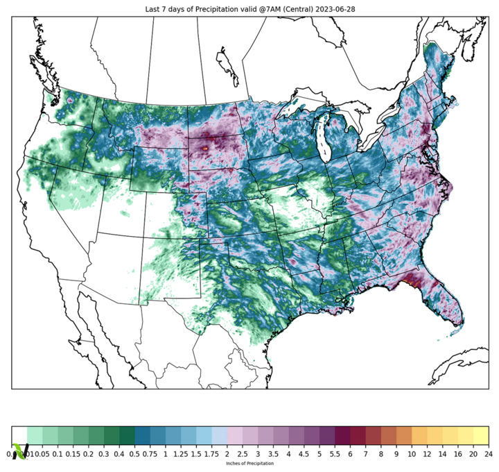
Most of the southern third of Nebraska received meaningful rain the morning of June 29, which means that most places in the state have picked up at least a quarter inch of moisture over the past seven days. That’s not going to put much of a dent in the drought, but it is the best moisture that’s fallen in some places in two to three weeks.
Wednesday Heat
The one saving grace so far this season in eastern Nebraska — where drought has been the most acute — is that there has been a lack of extreme heat thus far this summer. That changed yesterday with temperatures in the mid to upper 90s across much of the southeastern quadrant of the state.
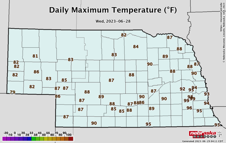
Warmest temperatures were found over Lancaster County, where a combination of extremely dry ground/soils and some compressional warming along a weak cold front led to temperatures approaching or exceeding 100. The Lincoln Airport, which tends to be a localized hot spot, hit 101°F yesterday. Following closely behind were the Crete Co-op, Lincoln East Campus Mesonet and Eagle Mesonet sites at 99°F for maximum temperatures. This wasn’t record heat but it certainly was not welcome.
Areas to the west of Seward that were behind the boundary during the afternoon had more seasonal temperatures in the upper 80s to lower 90s.
Temperatures across most of the state have been somewhat above average for the month, with the exception of the Panhandle and southwestern regions.
Temperature anomalies this month have been strongest across the northeastern part of the state, which sits at the southern end of an area of more impressive positive temperature anomalies that have occurred over the eastern Dakotas and Minnesota.
Vegetation and Crop Condition Update
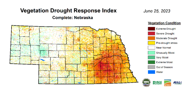
The latest VegDRI map is in good agreement with the U.S. Drought Monitor map, which shows the worst conditions in the area between Aurora and Seward and down into Saline County. Many rainfed crops were near-death in those areas earlier this week. We are likely at a point now where the best-case scenario for rainfed corn in those areas is limited yield potential, even if the rest of the summer is better. Irrigated corn and soybean in the Upper and Lower Big Blue NRDs may also suffer this year due to prohibitions on surface water irrigation for farms with permits after 1968. Those restrictions are in place to help meet stream flow compacts with Kansas.
In the Lincoln and Omaha metro areas, the duration and acuteness of the drought is taking a toll not just on yards but also on the trees. Spruce trees seem to be faring the worst, according to horticultural specialists. Some municipalities in the eastern part of the state, such as Waverly, are moving into mandatory water restrictions and fines for not complying.
The healthier vegetation in western Nebraska on VegDRI is evidence that the precipitation so far this spring and summer has helped bring back some lushness to pastures. Yield potential on crops in the areas Kearney and west should be quite high this year given adequate precipitation and a lack of heat. VegDRI also is showing reasonably healthy vegetation across much of Dixon County, which has received a lot more precipitation this growing season than surrounding areas.
Speaking of crops, condition reports contain bad news and good news.
Pastures continue to improve in western Nebraska and the percentage of pasture statewide in poor to very poor condition is at 35%, which is about where it has been for most of the month. Expect that number to remain steady until conditions in eastern Nebraska start to improve.
Corn and soybean came in at 16% and 20% poor-very poor, respectively, on the latest NASS update. While that may not seem too terrible, it is basically the worst for both crops at this point in the season since NASS started routinely reporting condition statistics in 1986.
Almost all of the winter wheat in the state is past the heading stage. As we head into harvest season, the percentage of wheat in good to excellent condition comes in at 40%, compared to 30% in poor-very poor. This is a decent improvement over earlier in the season and is quite a bit better than at this point last year, when the ratings came in at 22% and 34% for good-excellent and poor-very poor, respectively.
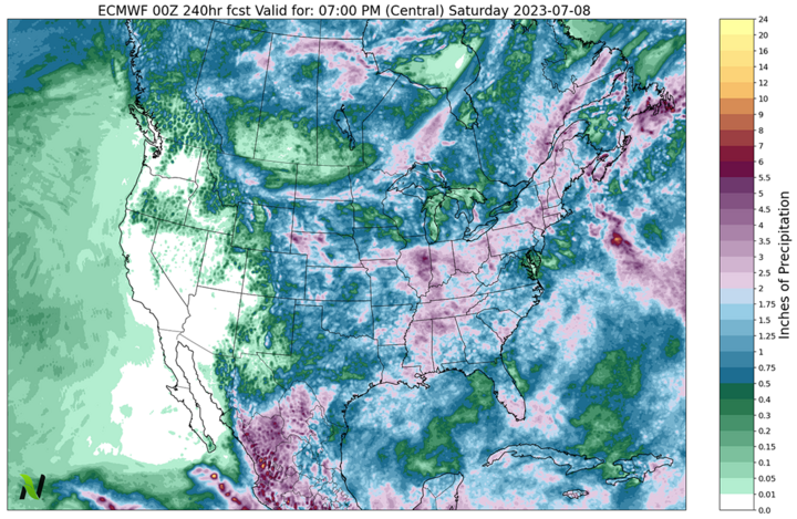
Precipitation Outlook
Much of the state stands to pick up meaningful precipitation over the next few days, particularly in some of the areas where drought is currently most extreme. If the forecast from the ECMWF verifies, there will be continued removal of drought in western Nebraska and perhaps some improvement in parts of eastern Nebraska.
